Area Overview for NW5 3LA
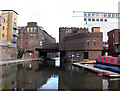
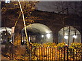
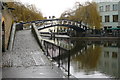
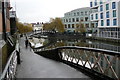
Photos of NW5 3LA


Area Information
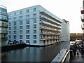
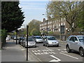
Living in NW5 3LA means residing within a distinct residential cluster that spans just 3,847 square metres in North West London. This compact postcode serves a specific population of 1,535 people, currently exhibiting an exceptionally high population density of 398,993 people per square kilometre. Such density creates an environment where everyday life moves quickly and neighbours are inevitably close. The location sits at the intersection of several major transport corridors, offering immediate access to Kentish Town West Station, Camden Road Station, and Gospel Oak Station. Commuters also benefit from nearby Tube access at Chalk Farm, Camden Town, and Tufnell Park, alongside services from London Victoria Coach Station. Daily existence here is characterised by convenience rather than spaciousness. Residents find supermarkets like Tesco Kentish, Co-op Kentish, and Sainsburys Kentish within practical reach, ensuring daily shopping needs are met locally. Water-based leisure is another notable feature, with the Camden Lock Waterbus, London Zoo Waterbus Stop, and Little Venice Waterbus Stop providing options for travelling across Regent's Canal. For those working from home, digital infrastructure is robust, with fixed broadband scoring 98 out of 100 and mobile coverage reaching 85. However, potential buyers must weigh these logistical advantages against the compact nature of the area and the high concentration of residents in such a small footprint.
- Area Type
- Postcode
- Area Size
- 3847 m²
- Population
- 1535
- Population Density
- 15258 people/km²
Homes in NW5 3LA reflect the constraints of urban planning in a densely populated city centre zone. With 45% home ownership, the market consists of a balanced mix of owner-occupiers and tenants. This split often indicates a vibrant lettings sector alongside a stable buying base. The accommodation type is overwhelmingly flats, a direct result of the need to maximise space within the limited 3,847 square metre footprint. Residents live in a cluster of 1,535 people, meaning property values here cater to those comfortable with high-density living. Potential buyers looking at this postcode should anticipate units designed for efficiency rather than sprawling gardens or two-story layouts. The high population density of 398,993 people per square kilometre ensures that developments are maximised vertically. flats typically form the core of the housing stock, offering convenience close to transport hubs like Kentish Town West Station and Camden Road Station. For those unwilling or unable to purchase, the rental market thrues due to the 45% ownership gap. Whether you buy or rent, the housing supply focuses on functional living spaces that facilitate rapid commutes and proximity to amenities like Sainsburys Kentish. The market is less about unique architectural features and more about secure location, connectivity, and rental yield potential given the demographic weight of adults aged 30 to 64.
House Prices in NW5 3LA
Showing 62 properties
Energy Efficiency in NW5 3LA
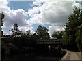
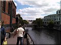
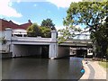
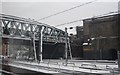
Living in NW5 3LA places you at the heart of a retail and leisure network centred on Kentish Town. Supermarkets such as Tesco Kentish, Co-op Kentish, and Sainsburys Kentish offer immediate access to groceries and daily essentials. Residents do not need to travel far to restock fridges or compare prices among these three major chains. Dining and shopping options extend beyond the high street, supported by the vibrant commercial activity around these anchors. Recreational opportunities are equally accessible. The presence of five ferry stops within practical reach includes the Camden Lock Waterbus, London Zoo Waterbus Stop, and Little Venice Waterbus Stop. These venues link the canal to attractions like the London Zoo and other points along the Regent's Canal network. Five railway stations serve the area, while five Tube stations including Chalk Farm and Camden Town provide rapid access to the rest of the capital. Three major bus terminals, including London Victoria Coach Station, handle lengthy inter-city journeys. This density of amenities ensures that whether you seek a quick coffee or a weekend trip to St Albans, your options are limitless and integrated into the fabric of daily life in this specific postcode.
Amenities
Schools
| Rank | School | Type | Entry gender | Ages |
|---|
Explore more schools in this area
Go to Schools tabDemographics
The community within NW5 3LA is defined by a mature demographic profile, with a median age of 47 years. The majority of residents fall into the adult bracket spanning 30 to 64 years, indicating a neighbourhood populated by established individuals and families rather than young professionals or students. Half of the population, representing 45% of households, owns their homes, suggesting a stable resident base with deep local roots. The remaining half likely comprises renters, contributing to a dynamic housing market typical of this zone. Accommodation types in this postcode are predominantly flats. This structural reality aligns with the extreme population density, where 398,993 people live per square kilometre. High-rise or mid-rise living arrangements allow the developer to house 1,535 people within 3,847 square metres and likely dominate the local skyline. While the predominant ethnic group identified is White, the diversity often found in London clap adds nuance to the daily social fabric. The age structure implies a quieter period during school holidays compared to areas dominated by children, yet the presence of adults with children remains probable given the median age. Families here may prioritise short commutes to local schools or rely on nearby Tube stations for transport links to educational institutions beyond the immediate vicinity.
Household Size
Accommodation Type
Tenure
Ethnic Group
Religion
Household Composition
Age
Household Deprivation
NS-SEC
Explore more demographic insights in this area
Go to Demographics tabPlanning
Planning Constraints
- Flood RiskPremium
- Ramsar Wetland SitesPremium
- Area of Outstanding Natural BeautyPremium
- Protected Nature ReservePremium
- Protected WoodlandPremium