Area Overview for NW2 6UR
Photos of NW2 6UR
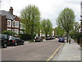
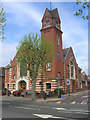
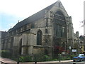
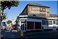
100 photos from this area
Area Information
Key information about the NW2 6UR including its size, population, and administrative classification.
- Area Type
- Postcode
- Area Size
- 4116 m²
- Population
- 1970
- Population Density
- 9091 people/km²
House Prices in NW2 6UR
19
Properties
£592,869
Average Sold Price
£138,000
Lowest Price
£1,250,000
Highest Price
Showing 19 properties
| Address | Type | Beds | Baths | Last Sale Price | Last Sale Date | |
|---|---|---|---|---|---|---|
| 103A Olive Road, London, NW2 6UR | Flat | 3 | 3 | £480,000 | Nov 2024 | |
| 99 Olive Road, London, NW2 6UR | house | - | - | £1,250,000 | Aug 2022 | |
| 85 Olive Road, London, NW2 6UR | Semi-detached | 3 | 2 | £1,050,000 | Nov 2015 | |
| 79 Olive Road, London, NW2 6UR | Semi-detached | - | - | £635,000 | Jun 2007 | |
| 77 Olive Road, London, NW2 6UR | house | 5 | 3 | £460,000 | Jan 2006 | |
| 91 Olive Road, London, NW2 6UR | house | - | - | £430,000 | Oct 2005 | |
| 83 Olive Road, London, NW2 6UR | Semi-detached | - | - | £299,950 | Jan 2000 | |
| 87 Olive Road, London, NW2 6UR | Semi-detached | - | - | £138,000 | Jun 1995 | |
| 97 Olive Road, London, NW2 6UR | Semi-detached | 4 | 2 | - | - | |
| 89A Olive Road, London, NW2 6UR | Flat | 2 | 1 | - | - |
Page 1 of 2
Energy Efficiency in NW2 6UR
Amenities
Schools
| Rank | School | Type | Entry gender | Ages |
|---|
Explore more schools in this area
Go to Schools tabDemographics
Household Size
Family (3-5 people)
most common
Accommodation Type
Flats
most common
Tenure
44
majority
Ethnic Group
White
most common
Religion
N/A
most common
Household Composition
N/A
most common
Age
47
median
Adults (30-64 years)
most common
Household Deprivation
N/A
with no deprivation
NS-SEC
33
in Lower managerial occupations
Explore more demographic insights in this area
Go to Demographics tabPlanning
Planning Constraints
- Flood RiskPremium
- Ramsar Wetland SitesPremium
- Area of Outstanding Natural BeautyPremium
- Protected Nature ReservePremium
- Protected WoodlandPremium