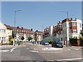
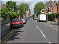
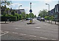
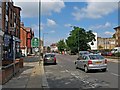
Area Overview for NW2 4QR
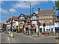
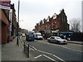
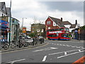
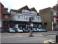
Photos of NW2 4QR


Area Information
Living in NW2 4QR means residing in a compact residential cluster defined by postcode 2794 square metres. This tiny area accommodates 1,379 people, creating a very dense environment where neighbours are rarely far away. The population density reaches an extreme 493,472 people per square kilometre. Life here revolves around the immediate surroundings of this small geographic footprint. You wake up to a setting where population pressures are intense given the limited land area available. This postcode represents a specific slice of the wider London landscape rather than a sprawling neighbourhood. Residents navigate a space where every square metre carries significant weight due to the high concentration of inhabitants. Daily life involves moving through a tightly packed zone where infrastructure supports a large number of people in a small space. The character of NW2 4QR is shaped by this sheer closeness of population. You experience a community where proximity is absolute and land use is critical. This area functions as a distinct unit within the larger transport and retail networks connecting to the rest of the city. Understanding the scale of this postcode helps you visualise the daily reality of living here.
- Area Type
- Postcode
- Area Size
- 2794 m²
- Population
- 1379
- Population Density
- 12086 people/km²
Homes in NW2 4QR are characterised by a rental market that outweighs owner-occupation. Data shows that only 31 per cent of homes are owned outright, meaning over two thirds are let properties. The predominant accommodation type within this postcode is the flat. This housing stock configuration suits singles, couples without children, or investors rather than families seeking space. You are buying or renting in an area where these flats are the standard architectural form. This high proportion of rental properties suggests the area appeals to those who prefer flexibility or are navigating the London rental market. For buyers, purchasing in NW2 4QR means entering a market where floor plans are likely vertical rather than expansive horizontal layouts. The density of 493,472 people per square kilometre reinforces the compact nature of the properties available. Trusting the data, you find that the estate layout prioritises high-yield units over spacious family homes. This market structure defines the financial and physical expectations for anyone acquiring a property here.
House Prices in NW2 4QR
Showing 11 properties
| Address | Type | Beds | Baths | Last Sale Price | Last Sale Date | |
|---|---|---|---|---|---|---|
| 55A Walm Lane, London, NW2 4QR | Flat | - | - | £260,000 | Apr 2022 | |
| 65A Walm Lane, London, NW2 4QR | Flat | - | - | - | - | |
| 67A Walm Lane, London, NW2 4QR | Flat | - | - | - | - | |
| Chicken Cottage, 53 Walm Lane, London, NW2 4QR | Retail | - | - | - | - | |
| 55B Walm Lane, London, NW2 4QR | Flat | - | - | - | - | |
| 61A Walm Lane, London, NW2 4QR | Flat | 1 | 1 | - | - | |
| 53A Walm Lane, London, NW2 4QR | Maisonette | - | - | - | - | |
| 59A Walm Lane, London, NW2 4QR | Flat | 1 | - | - | - | |
| 57A Walm Lane, London, NW2 4QR | Flat | 1 | - | - | - | |
| 63A Walm Lane, London, NW2 4QR | Flat | - | - | - | - |
Energy Efficiency in NW2 4QR
Your daily life in NW2 4QR benefits from several nearby amenities within practical reach. Five retail outlets serve the local shopping needs, featuring notable venues like Co-op Willesden and Sainsburys Willesden. These supermarkets allow you to carry out weekly groceries without needing to travel far. For commuting, five rail stations remain the most direct option, while five metro stops add flexibility to your journey planning. You might choose to explore the five ferry stops, including Little Venice Waterbus Stop or Camden Lock Waterbus, for leisure trips along the Regent's Canal. If driving is necessary, three major bus stations provide connections to coach services at London Victoria Coach Station. This array of facilities means you can satisfy most daily requirements locally. The concentration of specific brands like Sainsburys and Co-op confirms a commercial focus on convenience. Proximity to these tangible venues ensures your lifestyle remains grounded in accessible services rather than distant outposts.
Amenities
Schools
| Rank | School | Type | Entry gender | Ages |
|---|
Explore more schools in this area
Go to Schools tabDemographics
The community in NW2 4QR is dominated by adults aged 30 to 64 years. Specifically, the median age sits at 47 years, confirming that middle-aged residents form the core of this demographic. Younger families and school-age children are less common in this specific cluster compared to older adults. About 31 per cent of residents are home owners, which indicates that the majority live in rental properties. This high level of renting often correlates with the accommodation type, which consists primarily of flats rather than detached homes or semi-detached houses. The white ethnic group forms the predominant demographic within this postcode area. With such a high population density of 493,472 people per square kilometre, residents experience a living environment closely populated by their peers. The age profile suggests a stable, working-age population rather than an area focused on retirees or young professionals entering the workforce. You should expect a mature community where long-term tenants and investors dominate the housing market. The lack of significant owner-occupancy compared to owner-occupied housing areas shapes the social dynamics of the street.
Household Size
Accommodation Type
Tenure
Ethnic Group
Religion
Household Composition
Age
Household Deprivation
NS-SEC
Explore more demographic insights in this area
Go to Demographics tabPlanning
Planning Constraints
- Flood RiskPremium
- Ramsar Wetland SitesPremium
- Area of Outstanding Natural BeautyPremium
- Protected Nature ReservePremium
- Protected WoodlandPremium