Area Overview for NW1 6HT
Photos of NW1 6HT

Area Information
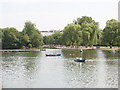
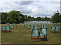
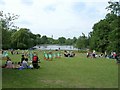
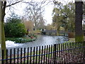
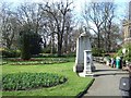
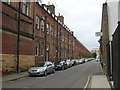
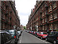
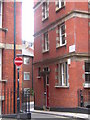
The postcode NW1 6HT defines a very compact residential cluster within the broader Regent's Park ward in north-west Inner London. This specific area covers just 1657 square metres, yet it accommodates a population of 1631 residents. At first glance, the population density figure is extreme, but it reflects the high-intensity nature of this urban cluster. Living in NW1 6HT places you in a historically significant setting, once part of Marylebone Park, which was originally a hunting ground for King Henry VIII before being redesigned by John Nash in the 1810s. The land was Grade I listed on the Register of Historic Parks and Gardens. Today, the immediate vicinity is dominated by the 410-acre Royal Regent's Park, which includes the London Zoo and Queen Mary's Gardens. While the postcode itself is a tiny footprint, its surroundings include Broad Walks, terraced dwellings, and the modern campus of Regent's University London, which occupies the site of South Villa within the park.
- Area Type
- Postcode
- Area Size
- 1657 m²
- Population
- 1631
- Population Density
- 14295 people/km²
The property market in NW1 6HT is fundamentally defined by rental demand rather than owner-occupation. Only 31% of residents own their homes, which indicates that over 69% of the population rents. This significant split means that if you are looking to buy, you are entering a market where tenancy is the norm. The predominant accommodation type is flats, so you should expect to find high-rise or purpose-built blocks rather than traditional detached family homes. This small postcode area of 1657 square metres reflects a dense urban fabric where space at ground level is scarce. Prospective buyers should approach the market with the expectation that competition for limited flats among private landlords and institutional investors will be higher than in owner-occupied suburbs.
House Prices in NW1 6HT
Showing 38 properties
| Address | Type | Beds | Baths | Last Sale Price | Last Sale Date | |
|---|---|---|---|---|---|---|
| 13 Linhope Street, London, NW1 6HT | Terraced | 4 | 3 | £2,575,000 | Oct 2023 | |
| 24 Linhope Street, London, NW1 6HT | Terraced | 5 | 4 | £2,600,000 | Jun 2017 | |
| 16 Linhope Street, London, NW1 6HT | Terraced | 3 | - | £1,150,000 | Jun 2013 | |
| 15 Linhope Street, London, NW1 6HT | Terraced | 3 | 2 | £1,200,000 | Aug 2010 | |
| 23 Linhope Street, London, NW1 6HT | Terraced | 3 | 1 | £1,725,000 | Dec 2009 | |
| 24A Linhope Street, London, NW1 6HT | Flat | - | - | £695,000 | Jan 2006 | |
| 22 Linhope Street, London, NW1 6HT | Detached | 3 | 2 | £755,000 | Sep 2005 | |
| 20 Linhope Street, London, NW1 6HT | house | - | - | £650,000 | Mar 2002 | |
| 14 Linhope Street, London, NW1 6HT | Terraced | - | - | £250,000 | Nov 2000 | |
| 21 Linhope Street, London, NW1 6HT | Terraced | 3 | 2 | - | - |
Energy Efficiency in NW1 6HT
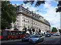
Your daily life in NW1 6HT is serviced by a dense network of transport and retail hubs located just steps away. Retail choices include Co-op Park, Marks & Spencer Marylebone Rail SF, and Tesco Marylebone, ensuring you can shop for essentials and groceries without travelling far. Transport options are extensive, with Metro stations including Baker Street, Edgware Road, and Regent's Park Station all within practical reach. You also have access to five rail stations including Paddington and London Euston, plus ferry services like the London Zoo Waterbus Stop. For daily exercise, you can walk to Queen Mary's Gardens or the Broad Walk, which are key features of the 410-acre Royal Park nearby. This concentration of amenities means you rarely need to leave the immediate vicinity for daily errands or leisure activities.
Amenities
Schools
Families considering homes in NW1 6HT have limited schooling options immediately on their doorstep. The closest primary education is provided by St Edward's Catholic Primary School, which holds a 'good' Ofsted rating. For children with special educational needs, Abingdon House School is located nearby and operates as a special school. This mix of a 'good' rated mainstream primary and a specialist school reflects the immediate needs of local families without a wide range of alternative choices. While the nearest primary school has a positive rating, the absence of secondary school data in this specific cluster requires families to look further into the wider Marylebone area for comprehensive education options for older children.
| Rank | School | Type | Entry gender | Ages |
|---|
Explore more schools in this area
Go to Schools tabDemographics
The community in NW1 6HT reflects a mature, adults-only demographic. The median age is 47, and the most common age range for residents is adults aged between 30 and 64 years. This profile suggests a neighbourhood established by long-term residents rather than young families moving in. Home ownership stands at 31%, meaning roughly two-thirds of residents rent their properties. The predominant accommodation type for this area is flats, which aligns with the high-density urban environment of Marylebone. You will also find a community where the White ethnic group is the predominant demographic. These specific figures indicate a stable, renting-heavy community of older adults living primarily in flat units within the historic fabric of the ward.
Household Size
Accommodation Type
Tenure
Ethnic Group
Religion
Household Composition
Age
Household Deprivation
NS-SEC
Explore more demographic insights in this area
Go to Demographics tabPlanning
Planning Constraints
- Flood RiskPremium
- Ramsar Wetland SitesPremium
- Area of Outstanding Natural BeautyPremium
- Protected Nature ReservePremium
- Protected WoodlandPremium