Area Overview for NW1 6BY
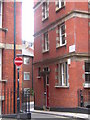
Photos of NW1 6BY


Area Information
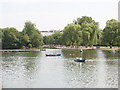
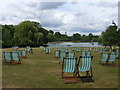
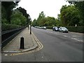
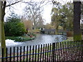
The postcode district NW1 6BY occupies a compact residential cluster within the historic Regent's Park Ward. This specific area covers just 703 square metres and holds a population of 1,631 people. The location places residents directly adjacent to a 410-acre Royal Park, formerly part of the hunting grounds appropriated by King Henry VIII in the 1530s. Architect John Nash later redesigned the land in the 1810s as a pleasure garden featuring villa residences and terraced dwellings. Today, the site includes Queen Mary's Gardens in the Inner Circle, the Avenue Gardens, and the Broad Walk. Regent's University London now occupies the former South Villa. Living in NW1 6BY means you are surrounded by this Grade I listed historic landscape and modern educational institutions. The high population density reflects the small geographic footprint, creating an intimate community feel uncommon in wider London districts. While the area is physically small, its location offers immediate proximity to significant landmarks and transport links without the sprawl of other zones. You reside in a neighbourhood where history defines the boundaries, with the park's vast expanse forming a constant backdrop to daily life.
- Area Type
- Postcode
- Area Size
- 703 m²
- Population
- 1631
- Population Density
- 14295 people/km²
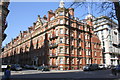
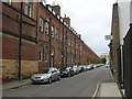
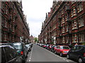
Properties in NW1 6BY are characterised by a specific tenure split and housing type. Only 31% of homes in this postcode are owner-occupied, meaning 69% of the 1,631 residents rent their accommodation. Consequently, you are more likely to find a landlord managing the stock than individuals seeking to move into freehold houses. The accommodation type data confirms that flats are the primary residential form within this cluster. This housing type corresponds with the area's small 703 square metre size, making large detached properties unfeasible. When viewing homes in NW1 6BY, focus on vertical living solutions and shared building amenities. The low ownership rate suggests a dynamic rental market driven by professionals or investors rather than legacy families building generational wealth in these specific coordinates. Buyers looking for freehold properties may need to cast their net wider to neighbouring postcodes while still benefiting from Regent's Park's proximity. If you prefer rental living, the area offers immediate access to a substantial inventory of flats. Understanding this market structure helps clarify expectations regarding lease terms and service charges common in London flat developments.
House Prices in NW1 6BY
Showing 11 properties
| Address | Type | Beds | Baths | Last Sale Price | Last Sale Date | |
|---|---|---|---|---|---|---|
| 6A Ivor Place, London, NW1 6BY | Flat | - | - | £560,000 | Jun 2001 | |
| 10 Ivor Place, London, NW1 6BY | Terraced | 3 | 2 | £324,000 | May 1995 | |
| Flat, 6 Ivor Place, London, NW1 6BY | Maisonette | 2 | 1 | - | - | |
| Flat 1, 5 Ivor Place, London, NW1 6BY | Flat | 1 | 1 | - | - | |
| Second Floor Flat, 7 Ivor Place, London, NW1 6BY | Flat | - | - | - | - | |
| Ground Floor Flat, 7 Ivor Place, London, NW1 6BY | Flat | - | - | - | - | |
| First Floor Flat, 7 Ivor Place, London, NW1 6BY | Flat | 2 | 2 | - | - | |
| Basement And Ground Floor, 6 Ivor Place, London, NW1 6BY | retail_financial | - | - | - | - | |
| First Floor Flat, 8-9 Ivor Place, London, NW1 6BY | Flat | - | - | - | - | |
| Second Floor Flat, 8-9 Ivor Place, London, NW1 6BY | Flat | 2 | 2 | - | - |
Energy Efficiency in NW1 6BY
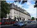
Residents of NW1 6BY benefit from immediate access to major shopping hubs and transport nodes. Convenience stores and retailers include Co-op Park, M&S Marylebone Rail SF, and Tesco Marylebone. These five retail options are within practical reach, covering everyday grocery needs and department store shopping. Five metro stations lie nearby, providing rapid links to the rest of London. Baker Street Station, Edgware Road Station, and Regent's Park Station offer direct connections to key business and leisure districts. Another five rail stations, including Paddington Station and London Euston Railway Station, serve long-distance travel needs. Commuters utilise three major bus terminuses, notably London Victoria Coach Station and the Green Line Coach Station. Recreation extends to three waterfront ferry stops, including the London Zoo Waterbus Stop and Camden Lock Waterbus. This network allows you to bypass road congestion by using water taxis to cross the Grand Canal. The combination of high-street retail, multiple transport modes, and waterway access creates a versatile lifestyle. You can shop morning and travel evening without leaving immediate vicinity, supported by five primary amenity categories.
Amenities
Schools
Families considering NW1 6BY will find two specific institutions listed as nearby schools. St Edward's Catholic Primary School operates in the immediate vicinity and holds a good Ofsted rating. This facility provides primary education for younger children within walking distance of the residential cluster. Abingdon House School also serves the local community, though its special education type limits its scope to specific student needs rather than general primary or secondary provision. This mix means parents with standard academic goals must look beyond the immediate neighbourhood for comprehensive secondary education options. However, the presence of a good-rated primary school ensures that early years education is accessible without requiring long commutes. The special school presence indicates a commitment to inclusive education within the broader Marylebone governance area. Residents of NW1 6BY can rely on St Edward's for their youngest children while planning a wider catchment search for older pupils. The limited school data reflects the postcode's small scale, which often acts as a residential dormitory community for students attending larger institutions in adjacent wards.
| Rank | School | Type | Entry gender | Ages |
|---|
Explore more schools in this area
Go to Schools tabDemographics
The community in NW1 6BY is defined by a mature demographic profile with a median age of 47 years. Most residents fall into the three-to-sixty-four-year-old age bracket, suggesting a population composed largely of adults and families rather than young tenants or retirees. Approximately 31% of households in this postcode own their homes, indicating that the majority of residents are long-term tenants. The predominant housing stock consists of flats, which aligns with the high-density nature of the 703 square metre zone. This structural reality supports a lifestyle centred on urban living rather than detached family estates. The area remains ethnically diverse enough to avoid homogeneity, though White remains the predominant group. With 1,631 residents packed into such a small footprint, social interactions are frequent and neighbours likely know each other well. The age distribution suggests a stable community where residents have established roots rather than transient populations. This demographic makeup influences local spending habits and community engagement, fostering an environment that prioritises convenience and established social networks over rapid turnover.
Household Size
Accommodation Type
Tenure
Ethnic Group
Religion
Household Composition
Age
Household Deprivation
NS-SEC
Explore more demographic insights in this area
Go to Demographics tabPlanning
Planning Constraints
- Flood RiskPremium
- Ramsar Wetland SitesPremium
- Area of Outstanding Natural BeautyPremium
- Protected Nature ReservePremium
- Protected WoodlandPremium