Area Overview for IG4 5PZ
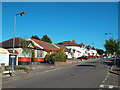
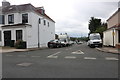
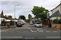
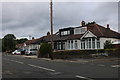
Photos of IG4 5PZ


Area Information
IG4 5PZ is a compact residential postcode in England, spanning 24.5 hectares and home to 1,808 residents. Its high population density of 7,365 people per square kilometre reflects a tightly knit community, though the area’s small size means it is more of a cluster than a sprawling suburb. The postcode is characterised by a predominance of houses, with 80% of residents owning their homes. This suggests a stable, long-term population, with the median age of 47 indicating a mature demographic. Daily life here is shaped by proximity to transport hubs and retail centres, though the area’s limited size means residents often rely on nearby districts for broader amenities. The presence of special schools and a mix of metro, rail, and bus connections ensures accessibility, though the high flood risk score of 43.7 (a critical level) is a notable consideration for prospective buyers. For those seeking a quiet, established residential environment with strong local infrastructure, IG4 5PZ offers a blend of practicality and community focus.
- Area Type
- Postcode
- Area Size
- 24.5 hectares
- Population
- 1808
- Population Density
- 2956 people/km²
The property market in IG4 5PZ is dominated by owner-occupied homes, with 80% of residents owning their properties. This high home ownership rate indicates a stable market where long-term residency is common. The accommodation type is primarily houses, which are more prevalent than flats or apartments, suggesting a preference for traditional residential living. Given the area’s small size and high population density, the housing stock is likely limited, with buyers needing to consider nearby postcode areas for additional options. The predominance of houses may appeal to families or individuals seeking more space, though the compact nature of the postcode means properties are closely spaced. For buyers, this implies a focus on quality over quantity, with homes likely to be well-maintained and situated in a mature, established neighbourhood. The market may be less influenced by rental demand, reflecting the strong presence of owner-occupiers.
House Prices in IG4 5PZ
No properties found in this postcode.
Energy Efficiency in IG4 5PZ
Living in IG4 5PZ offers access to a range of amenities within practical reach. Retail options include major supermarkets like Tesco Woodford and Co-op Wanstead, ensuring everyday shopping is straightforward. The area’s transport hubs, such as Redbridge Station and Whipps Cross Bus Interchange, provide easy access to London’s transport network, while rail links to Leytonstone High Road Station and Ilford Station connect to further destinations. For leisure, the proximity to London City Airport and ferry piers like East India Pier adds to the area’s accessibility for travel and events. While the area itself is small, its integration with nearby districts means residents can enjoy a broader array of services, from dining to cultural attractions. The combination of retail, transport, and connectivity makes daily life efficient, though the limited local parks or green spaces may require residents to seek outdoor activities elsewhere.
Amenities
Schools
The schools near IG4 5PZ include Hatton Special School, Lilyvale, and Stradbroke, all of which are special schools. Stradbroke holds an Ofsted rating of ‘good’, indicating a satisfactory standard of education. The presence of multiple special schools suggests the area is well-suited for families with children requiring specialist educational support. However, the absence of mainstream primary or secondary schools means residents may need to look beyond the immediate postcode for broader educational options. For families relying on special schools, the availability of three institutions provides some choice, though the specific needs of a child will determine the suitability of each. The mix of school types highlights the area’s focus on supporting diverse educational requirements, though it may not cater to all family needs without additional commuting.
| Rank | School | Type | Entry gender | Ages |
|---|
Explore more schools in this area
Go to Schools tabDemographics
The community in IG4 5PZ is predominantly composed of adults aged 30–64, with a median age of 47. This suggests a population that is largely settled, with fewer young families or retirees compared to other areas. Home ownership is high at 80%, indicating a strong presence of long-term residents. The accommodation type is primarily houses, which aligns with the area’s residential character. The predominant ethnic group is Asian_total, reflecting a culturally diverse but cohesive community. While specific deprivation data is not provided, the high home ownership rate and stable age profile imply a relatively secure economic environment. However, the high population density may impact local amenities and housing availability, particularly for those seeking larger properties or additional space. The area’s demographics suggest a focus on stability and community ties, with residents likely prioritising proximity to services and transport.
Household Size
Accommodation Type
Tenure
Ethnic Group
Religion
Household Composition
Age
Household Deprivation
NS-SEC
Explore more demographic insights in this area
Go to Demographics tabPlanning
Planning Constraints
- Flood RiskPremium
- Ramsar Wetland SitesPremium
- Area of Outstanding Natural BeautyPremium
- Protected Nature ReservePremium
- Protected WoodlandPremium