Area Overview for E14 0DE
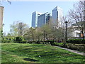
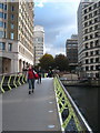
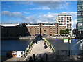
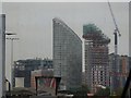
Photos of E14 0DE


Area Information
Living in E14 0DE means residing in a densely populated residential cluster defined by postcode constraints. This specific area covers just 6298 square metres, yet it houses 1690 people. The population density is extremely high at 268347 people per square kilometre, creating a distinct urban environment. You will find flats as the predominant form of accommodation within these boundaries. The median age for residents is 47 years, indicating a community where adulthood extends into later life stages. Most residents fall into the adult bracket between 30 and 64 years old. This compact footprint suggests a neighbourhood where space is limited, but location access is often maximised. Living in E14 0DE offers immediate proximity to major transit hubs and amenities due to the small geographic scale. The area functions as a tightly knit micro-community rather than a sprawling district. Your daily life in E14 0DE revolves around navigating a high-density setting where neighbours are always nearby. The sheer number of people per unit of land defines the character of this locality. It is a place where convenience comes at the cost of space.
- Area Type
- Postcode
- Area Size
- 6298 m²
- Population
- 1690
- Population Density
- 11793 people/km²
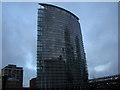
The property market in E14 0DE is characterised by a high prevalence of rental living rather than owner occupation. Only 22% of households are homeowners, which indicates a strong renting sector within this postcode. Flats are the consistent form of accommodation throughout the area, reflecting the vertical density typical of London's East End. This housing stock is designed for high-density living rather than detached family homes. You will find most properties suited to singles, couples, or small households due to the flat configuration. The low home ownership rate suggests buyers must be prepared to enter a competitive rental ladder or invest cautiously in flat buying. Homes in E14 0DE do not come in estate sizes but rather in efficient urban clusters. The small area size of 6298 square metres reinforces the idea that traditional garden plots are scarce or non-existent. Prospective buyers should expect to navigate a market where space premiums apply heavily. The accommodation style prioritises location and proximity to transport over expansive living room dimensions.
House Prices in E14 0DE
Showing 12 properties
Energy Efficiency in E14 0DE
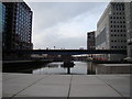
Your lifestyle in E14 0DE is driven by the immediate abundance of transport and retail options within practical reach. You have access to five metro stations, including Poplar, West India Quay, and All Saints, making car ownership less necessary. Five railway stations such as Canary Wharf Railway Station and Canada Water Station provide direct links to central London. There are also five ferry entrances, including the Canary Wharf Pier and East India Pier, offering scenic seafront travel. For daily shopping, you can find five retail outlets including Iceland Poplar, Tesco Canary, and Spar. Essential groceries and goods are just a short distance away. London City Airport stands accessible as a single airport option, ideal for business travellers. Four bus interchanges with major hubs like Whipps Cross further expand your travel radius. This density of amenities means private transport is secondary to public networks. The blend of sea access, rail, and underground creates a versatile routine.
Amenities
Schools
Families considering moving to or from E14 0DE have several educational institutions nearby to choose from. The area is served by Holy Family Catholic School and Our Lady and St Joseph Catholic Primary School. Both of these are primary schools that serve the younger education needs of local children. Our Lady and St Joseph Catholic Primary School holds a good Ofsted rating, providing families with a verified standard of education. Beyond primary education, residents have access to New City College, which functions as a sixth-form college. This institution supports students studying towards A-levels and other advanced qualifications. The combination of primary and sixth-form colleges means that children can remain within close proximity to their homes as they progress through different educational stages. You do not need to travel far for schooling in this postcode. The presence of Catholic schools also appeals to families seeking specific religious education. This mix ensures that practical schooling options are readily available for residents of E14 0DE.
| Rank | School | Type | Entry gender | Ages |
|---|
Explore more schools in this area
Go to Schools tabDemographics
The community in E14 0DE reflects a mature population structure with a clear focus on established households. The median age stands at 47 years, which places the demographic centre well above the national average for young families. Most commonly, the population consists of adults aged between 30 and 64 years. This age profile suggests a neighbourhood populated by professionals, empty nesters, or those in the peak earning years of their careers. Home ownership levels are relatively low at 22%, meaning the vast majority of residents rent their properties. Flats dominate the accommodation type statistics, aligning with the high-density nature of the postcode. Diversity is a significant feature of this community, with the Asian total group identified as the predominant ethnic group. The concentration of older adults combined with a reliance on rental housing points to a dynamic exchange of tenants rather than settled multi-generational families. Safety considerations are relevant here, as the area carries a medium crime risk level. Residents must remain conscious of standard security precautions to ensure their well-being. The social fabric is shaped by these specific demographic realities.
Household Size
Accommodation Type
Tenure
Ethnic Group
Religion
Household Composition
Age
Household Deprivation
NS-SEC
Explore more demographic insights in this area
Go to Demographics tabPlanning
Planning Constraints
- Flood RiskPremium
- Ramsar Wetland SitesPremium
- Area of Outstanding Natural BeautyPremium
- Protected Nature ReservePremium
- Protected WoodlandPremium