Area Overview for E13 8LS
Photos of E13 8LS
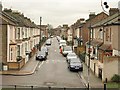
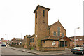

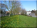


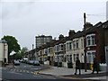
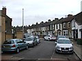
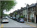
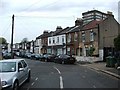


80 photos from this area
Area Information
Key information about the E13 8LS including its size, population, and administrative classification.
- Area Type
- Postcode
- Area Size
- 7809 m²
- Population
- 2261
- Population Density
- 15911 people/km²
House Prices in E13 8LS
42
Properties
£268,220
Average Sold Price
£51,802
Lowest Price
£477,000
Highest Price
Showing 42 properties
| Address | Type | Beds | Baths | Last Sale Price | Last Sale Date | |
|---|---|---|---|---|---|---|
| 129 Cumberland Road, Plaistow, London, E13 8LS | Terraced | 3 | 1 | £435,000 | Feb 2025 | |
| 123 Cumberland Road, Plaistow, London, E13 8LS | Terraced | 2 | 1 | £463,430 | Jan 2025 | |
| 111 Cumberland Road, Plaistow, London, E13 8LS | Terraced | 4 | 1 | £350,000 | Sep 2023 | |
| 171 Cumberland Road, Plaistow, London, E13 8LS | Terraced | 3 | 1 | £477,000 | Jun 2023 | |
| 127 Cumberland Road, Plaistow, London, E13 8LS | Terraced | 4 | 1 | £440,000 | Feb 2020 | |
| 117 Cumberland Road, Plaistow, London, E13 8LS | house | 3 | 1 | £430,000 | May 2019 | |
| 173 Cumberland Road, Plaistow, London, E13 8LS | Terraced | 3 | 1 | £375,500 | Aug 2017 | |
| 143 Cumberland Road, Plaistow, London, E13 8LS | Terraced | 3 | 1 | £350,000 | Oct 2016 | |
| 147 Cumberland Road, Plaistow, London, E13 8LS | Terraced | 3 | 1 | £359,000 | Nov 2015 | |
| 115 Cumberland Road, Plaistow, London, E13 8LS | Terraced | 3 | 1 | £325,000 | Jul 2014 |
Page 1 of 5
Energy Efficiency in E13 8LS
Amenities
Schools
| Rank | School | Type | Entry gender | Ages |
|---|
Explore more schools in this area
Go to Schools tabDemographics
Household Size
Family (3-5 people)
most common
Accommodation Type
Houses
most common
Tenure
32
majority
Ethnic Group
White
most common
Religion
N/A
most common
Household Composition
N/A
most common
Age
47
median
Adults (30-64 years)
most common
Household Deprivation
N/A
with no deprivation
NS-SEC
20
in Lower managerial occupations
Explore more demographic insights in this area
Go to Demographics tabPlanning
Planning Constraints
- Flood RiskPremium
- Ramsar Wetland SitesPremium
- Area of Outstanding Natural BeautyPremium
- Protected Nature ReservePremium
- Protected WoodlandPremium