Area Overview for E12 6NH
Photos of E12 6NH


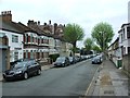


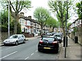

79 photos from this area
Area Information
Key information about the E12 6NH including its size, population, and administrative classification.
- Area Type
- Postcode
- Area Size
- 9496 m²
- Population
- 1893
- Population Density
- 15700 people/km²
House Prices in E12 6NH
48
Properties
£235,721
Average Sold Price
£52,600
Lowest Price
£562,000
Highest Price
Showing 48 properties
| Address | Type | Beds | Baths | Last Sale Price | Last Sale Date | |
|---|---|---|---|---|---|---|
| 156 Byron Avenue, Manor Park, London, E12 6NH | Terraced | 2 | 1 | £562,000 | Nov 2022 | |
| 172 Byron Avenue, Manor Park, London, E12 6NH | house | 3 | - | £428,500 | Feb 2019 | |
| 212 Byron Avenue, Manor Park, London, E12 6NH | Terraced | 3 | - | £465,000 | Jul 2016 | |
| 188 Byron Avenue, Manor Park, London, E12 6NH | house | 4 | 2 | £290,000 | May 2015 | |
| 166 Byron Avenue, Manor Park, London, E12 6NH | Terraced | 3 | 1 | £337,500 | Jan 2015 | |
| 234 Byron Avenue, Manor Park, London, E12 6NH | Terraced | 3 | 2 | £306,000 | Jan 2014 | |
| 206 Byron Avenue, Manor Park, London, E12 6NH | Terraced | 3 | 1 | £260,000 | Dec 2013 | |
| 184 Byron Avenue, Manor Park, London, E12 6NH | house | - | - | £243,000 | Jun 2013 | |
| 216 Byron Avenue, Manor Park, London, E12 6NH | house | - | - | £195,000 | Aug 2010 | |
| 200 Byron Avenue, Manor Park, London, E12 6NH | Terraced | - | - | £135,000 | May 2009 |
Page 1 of 5
Energy Efficiency in E12 6NH
Amenities
Schools
| Rank | School | Type | Entry gender | Ages |
|---|
Explore more schools in this area
Go to Schools tabDemographics
Household Size
Family (3-5 people)
most common
Accommodation Type
Houses
most common
Tenure
53
majority
Ethnic Group
asian_total
most common
Religion
N/A
most common
Household Composition
N/A
most common
Age
47
median
Adults (30-64 years)
most common
Household Deprivation
N/A
with no deprivation
NS-SEC
20
in Lower managerial occupations
Explore more demographic insights in this area
Go to Demographics tabPlanning
Planning Constraints
- Flood RiskPremium
- Ramsar Wetland SitesPremium
- Area of Outstanding Natural BeautyPremium
- Protected Nature ReservePremium
- Protected WoodlandPremium