Area Overview for DA16 2ND
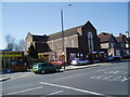
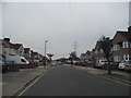
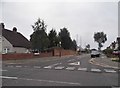
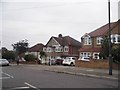
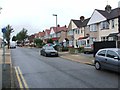
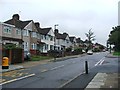
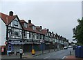
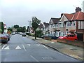
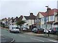
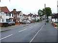
Photos of DA16 2ND


Area Information
DA16 2ND is a small residential cluster situated in the London Borough of Bexley, covering an area of 6,599 square metres. Approximately 1,658 people reside within these boundaries, creating a very tight-knit community. The location lies near the historic Watling Street, also known today as the A207, west of Bexleyheath. This postcode area is part of the Falconwood and Welling ward, which has established itself through years of local governance and community development. The physical footprint is modest, meaning residents are often neighbours to one another in a concentrated setting. You will find the area is centred around domestic living rather than commercial expansion. The low number of homes and the defined boundaries suggest a quiet environment where daily life revolves around local facilities rather than long commutes to distant entertainment. Understanding the scale of DA16 2ND helps you grasp the privacy you might enjoy. The specific postcode falls within the DA16 range, linking it to larger but familiar estates like those housing the New Ideal Homesteads developments from the 1930s. This context shapes the character of the postcode, anchoring it in a history that blends ancient manor lands with 20th-century housing schemes.
- Area Type
- Postcode
- Area Size
- 6599 m²
- Population
- 1658
- Population Density
- 6084 people/km²
Homes in DA16 2ND are primarily houses, constituting the main form of residential accommodation available. This fact distinguishes the area from clusters dominated by flats or apartments. With 87% of residents owning their properties, the market skews heavily towards owner-occupation rather than rental living. This statistic is significant for anyone considering buying in this postcode. The low vacancy rate implied by high ownership suggests that available properties may be scarce when they do come up for sale. You should expect competition if you wish to purchase a home here. The physical layout of 6,599 square metres indicates that the housing stock is limited in quantity. This scarcity often drives property values within such small, defined clusters. The dominance of houses means that the streets are likely lined with detached or semi-detached homes rather than blocks of flats. For buyers, this area offers a traditional housing experience. There are no signs of a commercial rental market dominating the housing stock. The market here relies on the stability of those who already hold the keys to these properties.
House Prices in DA16 2ND
Showing 20 properties
| Address | Type | Beds | Baths | Last Sale Price | Last Sale Date | |
|---|---|---|---|---|---|---|
| 76 Buckingham Avenue, Welling, DA16 2ND | Terraced | 3 | 1 | £500,000 | Apr 2022 | |
| 98 Buckingham Avenue, Welling, DA16 2ND | Detached | 3 | 1 | £425,000 | Aug 2020 | |
| 70 Buckingham Avenue, Welling, DA16 2ND | Terraced | 3 | 2 | £407,000 | Mar 2020 | |
| 66 Buckingham Avenue, Welling, DA16 2ND | Terraced | 4 | 2 | £320,000 | Oct 2015 | |
| 64 Buckingham Avenue, Welling, DA16 2ND | Terraced | 3 | 1 | £295,000 | Dec 2014 | |
| 84 Buckingham Avenue, Welling, DA16 2ND | house | - | - | £248,500 | Nov 2012 | |
| 88 Buckingham Avenue, Welling, DA16 2ND | Terraced | - | - | £222,500 | Oct 2007 | |
| 80 Buckingham Avenue, Welling, DA16 2ND | Terraced | - | - | £229,000 | Sep 2007 | |
| 96 Buckingham Avenue, Welling, DA16 2ND | Semi-detached | - | - | £201,000 | Feb 2004 | |
| 82 Buckingham Avenue, Welling, DA16 2ND | Terraced | - | - | £134,000 | Dec 1999 |
Energy Efficiency in DA16 2ND
Amenities
Schools
| Rank | School | Type | Entry gender | Ages |
|---|
Explore more schools in this area
Go to Schools tabDemographics
The community in DA16 2ND is defined by a settled population where 87% of residents own their homes. This high level of home ownership indicates a stable area where families are likely to put down roots. Houses form the predominant accommodation type, shaping a landscape designed for living rather than renting. The demographic profile shows a median age of 47, with adults between 30 and 64 years being the most common age range. This suggests that the population consists largely of working-age families or couples nearing retirement. The predominant ethnic group in this postcode is White, reflecting the broader patterns of the London Borough of Bexley. With such a low population density relative to the area size, families seeking a homeowning environment will find their needs met here. The age distribution reinforces the idea that this is not a student zone or a retirement-only village. Every aspect of the demographic data points to a mature residential cluster. You can expect neighbours who have likely grown old together. The combination of high ownership and an older adult population creates a very specific social fabric.
Household Size
Accommodation Type
Tenure
Ethnic Group
Religion
Household Composition
Age
Household Deprivation
NS-SEC
Explore more demographic insights in this area
Go to Demographics tabPlanning
Planning Constraints
- Flood RiskPremium
- Ramsar Wetland SitesPremium
- Area of Outstanding Natural BeautyPremium
- Protected Nature ReservePremium
- Protected WoodlandPremium