Area Overview for DA16 2JG
Photos of DA16 2JG

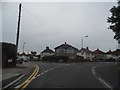
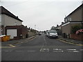
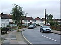
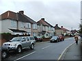
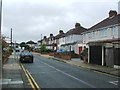
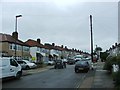
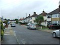
83 photos from this area
Area Information
Key information about the DA16 2JG including its size, population, and administrative classification.
- Area Type
- Postcode
- Area Size
- 1.1 hectares
- Population
- 1742
- Population Density
- 7691 people/km²
House Prices in DA16 2JG
38
Properties
£285,398
Average Sold Price
£74,500
Lowest Price
£458,000
Highest Price
Showing 38 properties
| Address | Type | Beds | Baths | Last Sale Price | Last Sale Date | |
|---|---|---|---|---|---|---|
| 6 Bradenham Avenue, Welling, DA16 2JG | Detached | 2 | 1 | £455,000 | Jul 2025 | |
| 54 Bradenham Avenue, Welling, DA16 2JG | Detached | 2 | 1 | £440,000 | Jun 2025 | |
| 52 Bradenham Avenue, Welling, DA16 2JG | Semi-detached | 4 | 1 | £356,000 | Jan 2024 | |
| 34 Bradenham Avenue, Welling, DA16 2JG | Semi-detached | 2 | 1 | £395,000 | Oct 2023 | |
| 36 Bradenham Avenue, Welling, DA16 2JG | Semi-detached | 3 | 1 | £438,000 | Nov 2022 | |
| 22 Bradenham Avenue, Welling, DA16 2JG | house | - | - | £440,000 | Aug 2022 | |
| 28 Bradenham Avenue, Welling, DA16 2JG | house | - | - | £376,000 | Sep 2021 | |
| 44 Bradenham Avenue, Welling, DA16 2JG | Semi-detached | 2 | 1 | £320,000 | Dec 2019 | |
| 4 Bradenham Avenue, Welling, DA16 2JG | Semi-detached | 2 | 1 | £355,000 | Nov 2019 | |
| 66 Bradenham Avenue, Welling, DA16 2JG | Semi-detached | 3 | 2 | £458,000 | Nov 2018 |
Page 1 of 4
Energy Efficiency in DA16 2JG
Amenities
Schools
| Rank | School | Type | Entry gender | Ages |
|---|
Explore more schools in this area
Go to Schools tabDemographics
Household Size
Family (3-5 people)
most common
Accommodation Type
Houses
most common
Tenure
90
majority
Ethnic Group
White
most common
Religion
N/A
most common
Household Composition
N/A
most common
Age
47
median
Adults (30-64 years)
most common
Household Deprivation
N/A
with no deprivation
NS-SEC
36
in Lower managerial occupations
Explore more demographic insights in this area
Go to Demographics tabPlanning
Planning Constraints
- Flood RiskPremium
- Ramsar Wetland SitesPremium
- Area of Outstanding Natural BeautyPremium
- Protected Nature ReservePremium
- Protected WoodlandPremium