Area Overview for DA16 1LB
Photos of DA16 1LB


Area Information
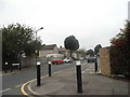
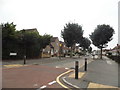
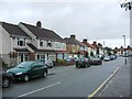
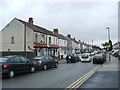
DA16 1LB is a compact residential cluster in the London Borough of Bexley, nestled within the historic district of East Wickham. This small area, spanning just 3.9 hectares, is home to 1,631 people, making it one of the most densely populated postcode areas in England, with 42,012 people per square kilometre. Its location offers a blend of suburban tranquillity and urban proximity, situated north of Welling and near key transport hubs. Historically, East Wickham was a rural settlement with roots tracing back to the 13th century, though large-scale housing developments from the 1910s transformed it into a residential community. Today, the area retains pockets of character, including St Michael’s Church and former open spaces. Living here means navigating a tight-knit, high-density environment where daily life is shaped by proximity to amenities, transport links, and the legacy of interwar expansion. The area’s small size means residents are likely to know their neighbours, though the density may feel intense for some.
- Area Type
- Postcode
- Area Size
- 3.9 hectares
- Population
- 1631
- Population Density
- 7945 people/km²
The property market in DA16 1LB is dominated by owner-occupied homes, with 70% of residents owning their properties. This high home ownership rate indicates a community of settled individuals, many of whom have lived in the area for years. The accommodation type is predominantly houses, which contrasts with areas where flats or apartments dominate. This suggests a more traditional, suburban housing stock, likely with garden spaces and family-oriented layouts. Given the area’s small size and high density, the housing stock is likely to be tightly packed, with limited scope for new builds. For buyers, this means properties are likely to be in demand, particularly among those seeking a stable, established neighbourhood. However, the compact nature of DA16 1LB means competition for available homes could be fierce, especially for those prioritising proximity to transport or amenities.
House Prices in DA16 1LB
No properties found in this postcode.
Energy Efficiency in DA16 1LB
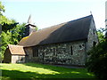
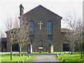
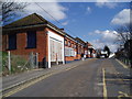
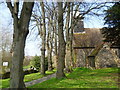
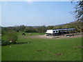
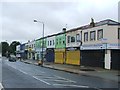
DA16 1LB offers a mix of retail, transport, and leisure options within easy reach. Local shops include major chains like Tesco Welling, Lidl Welling, and Co-op Welling, providing everyday essentials. Rail stations such as Welling and Bexleyheath Station offer regular services to London’s hubs, while ferry piers like Woolwich Arsenal Pier provide Thames-based travel options. The area’s proximity to London City Airport adds to its transport versatility. For leisure, St Michael’s Church and East Wickham Open Space offer historical and recreational value, though the latter’s former use as a greyhound track and swimming pool adds a unique character. The compact nature of the area means amenities are closely clustered, reducing the need for long commutes. However, the high population density may mean local facilities are busy, requiring residents to plan for peak times.
Amenities
Schools
| Rank | School | Type | Entry gender | Ages |
|---|
Explore more schools in this area
Go to Schools tabDemographics
DA16 1LB has a median age of 47, with the majority of residents falling within the 30-64 age range. This suggests a mature, stable population, likely with established careers and families. Home ownership is high at 70%, indicating a community of long-term residents rather than a transient rental market. The predominant accommodation type is houses, which aligns with the area’s suburban character. The dominant ethnic group is White, reflecting broader demographic trends in Bexley. The high population density—42,012 people per square kilometre—means the area is intensely populated, which can influence local services and social dynamics. While this density supports a vibrant community, it also means limited space for expansion or new developments. The age profile and ownership rates suggest a focus on stability, with residents likely prioritising long-term residency over short-term mobility.
Household Size
Accommodation Type
Tenure
Ethnic Group
Religion
Household Composition
Age
Household Deprivation
NS-SEC
Explore more demographic insights in this area
Go to Demographics tabPlanning
Planning Constraints
- Flood RiskPremium
- Ramsar Wetland SitesPremium
- Area of Outstanding Natural BeautyPremium
- Protected Nature ReservePremium
- Protected WoodlandPremium