Area Overview for DA14 4TA
Photos of DA14 4TA


Area Information
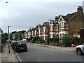
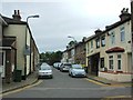
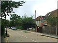
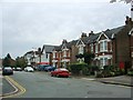
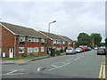
DA14 4TA is a small, densely populated postcode area in the London Borough of Bexley, situated 11.3 miles south-east of Charing Cross. Covering just 1809 square metres, it is a compact residential cluster with a population of 1871, translating to a population density of over a million people per square kilometre. This area, part of the Sidcup Ward, reflects the character of a 1930s London suburb built on former rural land, with housing estates like Penhill Park and Albany Park dominating the landscape. Daily life here is shaped by its suburban feel, with a mix of interwar development and modern infrastructure. Residents benefit from proximity to transport hubs, including Sidcup Station and London City Airport, and a network of rail, metro, and ferry links. The area’s history as a former hamlet, now a commuter suburb, offers a blend of historical charm and contemporary convenience. With a median age of 47, it is a mature community, ideal for those seeking a stable, well-connected environment near London’s bustling core.
- Area Type
- Postcode
- Area Size
- 1809 m²
- Population
- 1871
- Population Density
- 6034 people/km²
DA14 4TA is primarily an owner-occupied area, with 62% of homes owned by residents rather than rented. The accommodation type is predominantly flats, a feature inherited from the 1930s housing estates that define the area. This suggests a mature property market with limited new developments, as the housing stock is largely established. For buyers, this means a focus on existing properties rather than speculative investment. The high home ownership rate indicates a stable demand for housing, likely driven by the area’s proximity to transport links and London’s economic hubs. However, the small size of the postcode area and its density may limit the variety of properties available. Buyers should consider the suburban character and the need for proximity to London’s infrastructure when evaluating the market.
House Prices in DA14 4TA
No properties found in this postcode.
Energy Efficiency in DA14 4TA
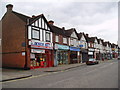
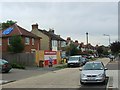
Living in DA14 4TA offers a range of amenities within practical reach. Retail options include major stores like Waitrose Little, Morrisons Sidcup, and Tesco Sidcup, catering to daily needs. The area’s transport links provide access to cultural and leisure opportunities, from the historic St John’s Church to the listed buildings of Sidcup Manor House. Residents can enjoy proximity to green spaces such as Footscray Meadows and the conservation area around The Hollies, which features a clock tower and water tower. The nearby London City Airport and ferry piers add to the area’s connectivity, while the 1930s architecture and suburban layout create a distinct character. This mix of retail, transport, and heritage sites supports a convenient, well-rounded lifestyle.
Amenities
Schools
| Rank | School | Type | Entry gender | Ages |
|---|
Explore more schools in this area
Go to Schools tabDemographics
DA14 4TA has a median age of 47, with the majority of residents aged between 30 and 64. This suggests a community of established professionals and families, reflecting the area’s suburban character. Home ownership is high at 62%, indicating a stable housing market with a focus on long-term residency. The predominant accommodation type is flats, a legacy of interwar housing developments. The predominant ethnic group is White, though specific diversity statistics are not provided. The population density of over a million people per square kilometre highlights a compact, closely knit neighbourhood. While this density may contribute to a sense of community, it also means limited open space. The age profile and ownership rates suggest a mature, low-turnover population, which can influence local services and amenities.
Household Size
Accommodation Type
Tenure
Ethnic Group
Religion
Household Composition
Age
Household Deprivation
NS-SEC
Explore more demographic insights in this area
Go to Demographics tabPlanning
Planning Constraints
- Flood RiskPremium
- Ramsar Wetland SitesPremium
- Area of Outstanding Natural BeautyPremium
- Protected Nature ReservePremium
- Protected WoodlandPremium