Area Overview for BR3 1NR
Photos of BR3 1NR
Area Information
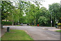
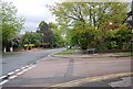
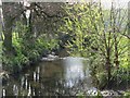
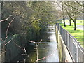
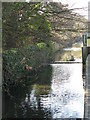
BR3 1NR represents a small, tightly knit residential cluster within the London Borough of Bromley. This specific postcode area spans just 1.2 hectares and is home to 1,880 residents. The location sits firmly within the Beckenham Town and Copers Cope ward, an area historically linked to the old Copers Cope Farm, which once occupied a substantial 250 acres across present-day New Beckenham. Today, the neighbourhood feels established yet intimately scaled, offering a distinct separation from the wider suburban sprawl of Beckenham. Residents here enjoy proximity to notable landmarks such as Beckenham Place Park, which was developed from the historic Cator estate and features a lake dating back to 1785. The presence of conservation areas along Copers Cope Road and Southend Road ensures that the architectural character remains consistent, with many large Victorian houses maintaining their original screened gardens. Living in BR3 1NR means residing within a community where the past and present intersect, allowing you to experience a quiet corner of Greater London that retains a significant portion of its historical identity while benefiting from modern suburban conveniences.
- Area Type
- Postcode
- Area Size
- 1.2 hectares
- Population
- 1880
- Population Density
- 6674 people/km²
Homes in BR3 1NR are characterised by a specific housing stock where flats are the predominant accommodation type. This suggests that the local market offers a diverse range of living options, appealing particularly to those seeking low-maintenance urban-style living within a suburban setting. The home ownership rate sits at exactly 50 per cent, placing the area in a balanced position between owner-occupied properties and rentals. This statistic is significant for potential buyers as it indicates a stable market where roughly half of the housing is available for purchase. When looking at homes in BR3 1NR, you are entering a market defined by its age; the area was largely developed for housing following the arrival of the railway in 1857, with significant building booms in the early 20th century around the established farming land. The fact that the area encompasses parts of the Copers Cope Road Conservation Area means that many properties are protected, which can influence both design and value. With 1,880 residents spread across 1.2 hectares, the property market is likely competitive, and the mix of flats combined with the high home ownership percentage suggests a mature, established estate rather than a new-build development zone.
House Prices in BR3 1NR
Showing 34 properties
| Address | Type | Beds | Baths | Last Sale Price | Last Sale Date | |
|---|---|---|---|---|---|---|
| 3, Klinton, Copers Cope Road, Beckenham, BR3 1NR | Maisonette | 2 | 1 | £436,000 | Jun 2023 | |
| 73B Copers Cope Road, Beckenham, BR3 1NR | Flat | 2 | 1 | £437,500 | Feb 2022 | |
| 87 Copers Cope Road, Beckenham, BR3 1NR | house | - | - | £2,000,000 | Jun 2021 | |
| 4, Klinton, Copers Cope Road, Beckenham, BR3 1NR | Maisonette | 2 | - | £417,000 | Dec 2020 | |
| 79B Copers Cope Road, Beckenham, BR3 1NR | Flat | - | - | £355,000 | Sep 2020 | |
| 79D Copers Cope Road, Beckenham, BR3 1NR | Flat | - | - | £279,250 | Oct 2012 | |
| 73A Copers Cope Road, Beckenham, BR3 1NR | house | - | - | £440,000 | Apr 2012 | |
| 67 Copers Cope Road, Beckenham, BR3 1NR | Semi-detached | 6 | - | £730,000 | Apr 2011 | |
| 79C Copers Cope Road, Beckenham, BR3 1NR | Flat | - | - | £204,995 | Jun 2006 | |
| 79A Copers Cope Road, Beckenham, BR3 1NR | Flat | - | - | £225,000 | Oct 2004 |
Energy Efficiency in BR3 1NR
Living in BR3 1NR places you within easy reach of a dense network of amenities that cater to daily needs and leisure pursuits. Five railway stations, including New Beckenham and Lower Sydenham, provide direct rail links, while five tram stops like the Avenue Road Tram Stop offer convenient local travel. For essential shopping, you have access to five major retail outlets, notably the Waitrose on Beckenham High Street, the Co-op on Beckenham Road, and Marks & Spencer (M&S) on Beckenham South End, all providing full-service groceries and household goods. The transport options continue with five pier locations along the Thames, such as Greenwich Pier and Greenland Surrey Quays Pier, enabling leisure travel and river access. Beyond shopping and transit, the area benefits from proximity to large Victorian conservation areas with historic architecture and screened gardens. The historic Copers Cope House, dating back to approximately 1690, stands as a testament to the area's heritage. For families and history enthusiasts, Beckenham Place Park is a central feature, offering walking paths, a lake, and the historic gate lodges to South Park Court. This blend of historical sites and modern retail convenience ensures that daily life in BR3 1NR is both culturally rich and logistically efficient.
Amenities
Schools
| Rank | School | Type | Entry gender | Ages |
|---|
Explore more schools in this area
Go to Schools tabDemographics
The community in BR3 1NR is defined by a mature population with a median age of 47 years. The most common age group consists of adults between 30 and 64 years old, indicating that families with dependent children and older professionals form the backbone of the neighbourhood. Half of the residents, accounting for 50 per cent, own their homes outright or have a mortgage, suggesting a stable, settled demographic rather than a transient rental market. The predominant ethnic group is White, contributing to a largely uniform community composition. While the area accommodates various lifestyles through its mix of housing, the data indicates a preference for flats as the primary accommodation type within this specific postcode sector. For those considering moving here, the population density stands at 152,757 people per square kilometre, a figure that highlights how compact this residential cluster is compared to the wider region. This high density within a small 1.2-hectare footprint creates an environment where neighbours are well-known and community cohesion is likely stronger than in more sprawling suburbs.
Household Size
Accommodation Type
Tenure
Ethnic Group
Religion
Household Composition
Age
Household Deprivation
NS-SEC
Explore more demographic insights in this area
Go to Demographics tabPlanning
Planning Constraints
- Flood RiskPremium
- Ramsar Wetland SitesPremium
- Area of Outstanding Natural BeautyPremium
- Protected Nature ReservePremium
- Protected WoodlandPremium