Area Overview for BR1 5PL
Photos of BR1 5PL

Area Information
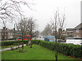
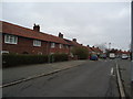
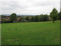
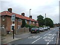
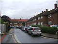
BR1 5PL is a small, densely populated residential cluster in southeast London, straddling parts of the London Borough of Lewisham and Bromley. With a population of 1,669 spread across just 1.1 hectares, the area is characterised by high density and a suburban, low-rise layout. Originally developed in the 1920s as a council estate by the London County Council, it was designed to rehouse families from overcrowded inner London areas. The architecture reflects post-WWI planning, with red-brick houses featuring front and back gardens, privet hedges, and corner shrub gardens. This area sits between Catford and Bromley, near the Kent border, and its history includes notable events such as the 1926 construction of a controversial class-dividing wall, later removed for safety. Today, BR1 5PL offers a mix of residential living with proximity to transport hubs, retail, and green spaces, making it a compact but functional part of southeast London’s suburban fabric.
- Area Type
- Postcode
- Area Size
- 1.1 hectares
- Population
- 1669
- Population Density
- 4822 people/km²
BR1 5PL’s property market is defined by its 50% home ownership rate and a focus on houses rather than flats or apartments. The area’s small size—just 1.1 hectares—means the housing stock is limited, with most properties being traditional brick-built homes designed for family living. This suggests a market where owner-occupation is common but not universal, with a significant portion of the housing stock likely rented out. The presence of houses rather than high-density developments may appeal to buyers seeking private gardens and a quieter, suburban environment. However, the area’s compact nature means that property availability is constrained, and buyers should consider proximity to transport and amenities as critical factors. The mix of ownership and rental properties may also influence local property prices and investment potential.
House Prices in BR1 5PL
No properties found in this postcode.
Energy Efficiency in BR1 5PL
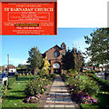
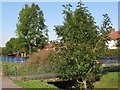
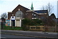
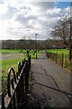
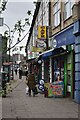
BR1 5PL’s residents have access to a range of amenities within practical reach. Retail options include M&S Downham Bromley BP, Iceland Downham, and Tesco Downham, offering everyday shopping needs. The area’s transport links connect to Beckenham Place Park and Downham Fields, providing green spaces for recreation. Nearby leisure facilities include the Downham Tavern, once renowned as the world’s largest pub, and historical sites like the Good Shepherd Catholic Church. The mix of retail, transport, and green spaces supports a convenient lifestyle, balancing suburban tranquillity with urban accessibility. The presence of multiple rail and metro stops also enhances connectivity to cultural and commercial hubs further afield.
Amenities
Schools
The nearest school to BR1 5PL is Greenvale School, which is categorised as a special school. No further details about its Ofsted rating or curriculum are provided in the data. The presence of a special school indicates that the area may cater to families with children requiring tailored educational support. However, the absence of other schools in the immediate vicinity suggests that families may need to look beyond BR1 5PL for additional educational options. This could be a consideration for prospective buyers prioritising a range of school types, though the existing school serves a specific need within the community.
| Rank | School | Type | Entry gender | Ages |
|---|
Explore more schools in this area
Go to Schools tabDemographics
The population of BR1 5PL has a median age of 47, with the majority of residents falling in the 30-64 age range. This suggests a community of established adults, many of whom may be in their prime working years or nearing retirement. Home ownership is at 50%, indicating a balanced mix of owner-occupied and rental properties. The predominant accommodation type is houses, reflecting a suburban, low-density layout typical of mid-20th-century estate planning. The predominant ethnic group is White, though the data does not specify further diversity metrics. With a population density of 149,470 people per square kilometre, the area is highly compact, which may influence community dynamics and access to shared spaces. This density, combined with the age profile, suggests a stable, long-term resident base with potential for localised social networks.
Household Size
Accommodation Type
Tenure
Ethnic Group
Religion
Household Composition
Age
Household Deprivation
NS-SEC
Explore more demographic insights in this area
Go to Demographics tabPlanning
Planning Constraints
- Flood RiskPremium
- Ramsar Wetland SitesPremium
- Area of Outstanding Natural BeautyPremium
- Protected Nature ReservePremium
- Protected WoodlandPremium