Area Overview for BR1 2SG
Photos of BR1 2SG
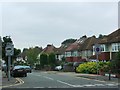
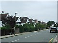
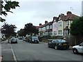
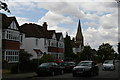
53 photos from this area
Area Information
Key information about the BR1 2SG including its size, population, and administrative classification.
- Area Type
- Postcode
- Area Size
- 1.0 hectares
- Population
- 1828
- Population Density
- 5199 people/km²
House Prices in BR1 2SG
16
Properties
£536,714
Average Sold Price
£152,500
Lowest Price
£1,250,000
Highest Price
Showing 16 properties
| Address | Type | Beds | Baths | Last Sale Price | Last Sale Date | |
|---|---|---|---|---|---|---|
| 115 Nightingale Lane, Bromley, BR1 2SG | Detached | 5 | 3 | £1,250,000 | Sep 2023 | |
| 97 Nightingale Lane, Bromley, BR1 2SG | house | - | - | £615,000 | Nov 2021 | |
| 87 Nightingale Lane, Bromley, BR1 2SG | Semi-detached | 3 | - | £530,000 | Feb 2018 | |
| 107 Nightingale Lane, Bromley, BR1 2SG | Semi-detached | 5 | - | £417,000 | Jul 2012 | |
| 91 Nightingale Lane, Bromley, BR1 2SG | Semi-detached | 3 | 2 | £412,500 | Jun 2012 | |
| 113 Nightingale Lane, Bromley, BR1 2SG | Semi-detached | - | - | £380,000 | Jun 2005 | |
| 111 Nightingale Lane, Bromley, BR1 2SG | Semi-detached | - | - | £152,500 | Mar 1998 | |
| 89 Nightingale Lane, Bromley, BR1 2SG | Semi-detached | 3 | 1 | - | - | |
| 99 Nightingale Lane, Bromley, BR1 2SG | Semi-detached | 3 | 2 | - | - | |
| 95 Nightingale Lane, Bromley, BR1 2SG | Semi-detached | 3 | 1 | - | - |
Page 1 of 2
Energy Efficiency in BR1 2SG
Amenities
Schools
| Rank | School | Type | Entry gender | Ages |
|---|
Explore more schools in this area
Go to Schools tabDemographics
Household Size
One person
most common
Accommodation Type
Flats
most common
Tenure
67
majority
Ethnic Group
White
most common
Religion
N/A
most common
Household Composition
N/A
most common
Age
47
median
Adults (30-64 years)
most common
Household Deprivation
N/A
with no deprivation
NS-SEC
50
in Lower managerial occupations
Explore more demographic insights in this area
Go to Demographics tabPlanning
Planning Constraints
- Flood RiskPremium
- Ramsar Wetland SitesPremium
- Area of Outstanding Natural BeautyPremium
- Protected Nature ReservePremium
- Protected WoodlandPremium