Area Overview for BR1 2PU
Photos of BR1 2PU
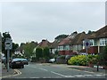
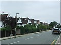
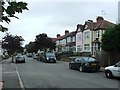
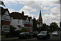
53 photos from this area
Area Information
Key information about the BR1 2PU including its size, population, and administrative classification.
- Area Type
- Postcode
- Area Size
- 2.3 hectares
- Population
- 1828
- Population Density
- 5199 people/km²
House Prices in BR1 2PU
40
Properties
£1,654,436
Average Sold Price
£1,450,000
Lowest Price
£2,025,052
Highest Price
Showing 40 properties
| Address | Type | Beds | Baths | Last Sale Price | Last Sale Date | |
|---|---|---|---|---|---|---|
| 1A Sundridge Avenue, Bromley, BR1 2PU | Detached | 7 | 5 | £1,825,000 | Mar 2023 | |
| 9 Sundridge Avenue, Bromley, BR1 2PU | house | - | - | £1,616,000 | Feb 2022 | |
| 1 Sundridge Avenue, Bromley, BR1 2PU | house | - | - | £1,750,000 | Sep 2021 | |
| 19 Sundridge Avenue, Bromley, BR1 2PU | hospital_care_home | - | - | £2,025,052 | Sep 2020 | |
| 3 Sundridge Avenue, Bromley, BR1 2PU | Detached | 6 | 4 | £1,465,000 | Sep 2017 | |
| 7 Sundridge Avenue, Bromley, BR1 2PU | house | - | - | £1,450,000 | May 2010 | |
| 17 Sundridge Avenue, Bromley, BR1 2PU | Detached | - | - | £1,450,000 | Aug 2005 | |
| Flat 4, 15 Sundridge Avenue, Bromley, BR1 2PU | Flat | 2 | 2 | - | - | |
| Flat 2, 5 Sundridge Avenue, Bromley, BR1 2PU | Flat | 3 | 3 | - | - | |
| Flat 6, 15 Sundridge Avenue, Bromley, BR1 2PU | Flat | 2 | - | - | - |
Page 1 of 4
Energy Efficiency in BR1 2PU
Amenities
Schools
| Rank | School | Type | Entry gender | Ages |
|---|
Explore more schools in this area
Go to Schools tabDemographics
Household Size
One person
most common
Accommodation Type
Flats
most common
Tenure
67
majority
Ethnic Group
White
most common
Religion
N/A
most common
Household Composition
N/A
most common
Age
47
median
Adults (30-64 years)
most common
Household Deprivation
N/A
with no deprivation
NS-SEC
50
in Lower managerial occupations
Explore more demographic insights in this area
Go to Demographics tabPlanning
Planning Constraints
- Flood RiskPremium
- Ramsar Wetland SitesPremium
- Area of Outstanding Natural BeautyPremium
- Protected Nature ReservePremium
- Protected WoodlandPremium