Area Overview for SG13 7BP
Photos of SG13 7BP
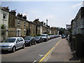
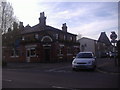
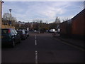
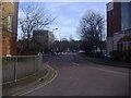
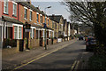
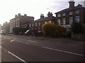
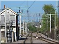
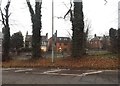
35 photos from this area
Area Information
Key information about the SG13 7BP including its size, population, and administrative classification.
- Area Type
- Postcode
- Area Size
- 8384 m²
- Population
- 1366
- Population Density
- 7560 people/km²
House Prices in SG13 7BP
41
Properties
£346,298
Average Sold Price
£85,000
Lowest Price
£780,000
Highest Price
Showing 41 properties
| Address | Type | Beds | Baths | Last Sale Price | Last Sale Date | |
|---|---|---|---|---|---|---|
| 11 Townshend Street, Hertford, SG13 7BP | house | 3 | 1 | £625,000 | Jul 2025 | |
| 28 Townshend Street, Hertford, SG13 7BP | Semi-detached | 2 | 1 | £545,000 | Mar 2023 | |
| 35A Townshend Street, Hertford, SG13 7BP | Flat | 2 | - | £427,000 | Mar 2021 | |
| 44 Townshend Street, Hertford, SG13 7BP | Terraced | 4 | 2 | £707,500 | Sep 2020 | |
| 31 Townshend Street, Hertford, SG13 7BP | Semi-detached | 2 | 2 | £520,000 | Oct 2017 | |
| 35 Townshend Street, Hertford, SG13 7BP | Terraced | - | - | £320,000 | Jan 2017 | |
| 36 Townshend Street, Hertford, SG13 7BP | Terraced | 2 | 1 | £340,000 | Jul 2016 | |
| 17 Townshend Street, Hertford, SG13 7BP | house | 2 | - | £350,000 | Oct 2015 | |
| 46 Townshend Street, Hertford, SG13 7BP | house | - | - | £415,000 | Mar 2014 | |
| 14 Townshend Street, Hertford, SG13 7BP | Semi-detached | 3 | 1 | £340,000 | Oct 2013 |
Page 1 of 5
Energy Efficiency in SG13 7BP
Amenities
Schools
| Rank | School | Type | Entry gender | Ages |
|---|
Explore more schools in this area
Go to Schools tabDemographics
Household Size
Two person
most common
Accommodation Type
Flats
most common
Tenure
48
majority
Ethnic Group
White
most common
Religion
N/A
most common
Household Composition
N/A
most common
Age
47
median
Adults (30-64 years)
most common
Household Deprivation
N/A
with no deprivation
NS-SEC
56
in Lower managerial occupations
Explore more demographic insights in this area
Go to Demographics tabPlanning
Planning Constraints
- Flood RiskPremium
- Ramsar Wetland SitesPremium
- Area of Outstanding Natural BeautyPremium
- Protected Nature ReservePremium
- Protected WoodlandPremium