Area Overview for SG13 7BN
Photos of SG13 7BN
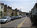
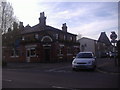
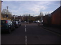
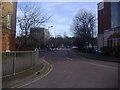
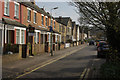
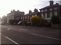
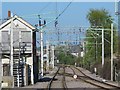
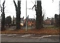
35 photos from this area
Area Information
Key information about the SG13 7BN including its size, population, and administrative classification.
- Area Type
- Postcode
- Area Size
- 5990 m²
- Population
- 1366
- Population Density
- 7560 people/km²
House Prices in SG13 7BN
20
Properties
£323,972
Average Sold Price
£51,995
Lowest Price
£780,000
Highest Price
Showing 20 properties
| Address | Type | Beds | Baths | Last Sale Price | Last Sale Date | |
|---|---|---|---|---|---|---|
| 138 Railway Street, Hertford, SG13 7BN | Maisonette | 2 | 1 | £330,000 | Jul 2025 | |
| 100 Railway Street, Hertford, SG13 7BN | Terraced | 4 | 2 | £770,000 | Nov 2021 | |
| 136 Railway Street, Hertford, SG13 7BN | Maisonette | 2 | 1 | £217,000 | Dec 2019 | |
| 104 Railway Street, Hertford, SG13 7BN | Terraced | 3 | 2 | £580,000 | Jan 2019 | |
| 110 Railway Street, Hertford, SG13 7BN | Terraced | 4 | 2 | £780,000 | Feb 2018 | |
| 126 Railway Street, Hertford, SG13 7BN | Flat | 2 | 1 | £290,000 | Feb 2017 | |
| 132 Railway Street, Hertford, SG13 7BN | Flat | 2 | 1 | £192,000 | Jan 2015 | |
| 98 Railway Street, Hertford, SG13 7BN | house | - | - | £407,000 | Jul 2014 | |
| 118 Railway Street, Hertford, SG13 7BN | house | - | - | £330,500 | Apr 2013 | |
| 128 Railway Street, Hertford, SG13 7BN | Flat | 2 | - | £170,000 | Nov 2011 |
Page 1 of 2
Energy Efficiency in SG13 7BN
Amenities
Schools
| Rank | School | Type | Entry gender | Ages |
|---|
Explore more schools in this area
Go to Schools tabDemographics
Household Size
Two person
most common
Accommodation Type
Flats
most common
Tenure
48
majority
Ethnic Group
White
most common
Religion
N/A
most common
Household Composition
N/A
most common
Age
47
median
Adults (30-64 years)
most common
Household Deprivation
N/A
with no deprivation
NS-SEC
56
in Lower managerial occupations
Explore more demographic insights in this area
Go to Demographics tabPlanning
Planning Constraints
- Flood RiskPremium
- Ramsar Wetland SitesPremium
- Area of Outstanding Natural BeautyPremium
- Protected Nature ReservePremium
- Protected WoodlandPremium