Area Overview for PE19 1JA
Photos of PE19 1JA


Area Information
Living in PE19 1JA offers a specific residential experience within a small, defined cluster. This postcode covers a mere 5,764 square metres, creating a dense neighbourhood of 2,034 people. The population density reaches 352,876 people per square kilometre, indicating extremely tight crowds and limited open space. You will find this area is a compact pocket of the wider Neots landscape where daily life revolves close to home. Because the land area is so small, the community feels intimate, yet the sheer number of residents packed into this space suggests a busy, high-intensity environment. Daily routines here are dictated by proximity. Residents do not venture far to access essentials, relying on the immediate vicinity for their daily needs. The area functions as a concentrated hub where neighbours live very close together, potentially leading to a vibrant but crowded atmosphere. Understanding the scale is vital for anyone considering PE19 1JA. It is not a sprawling suburb but a focused neighbourhood defined by its high density and small footprint. This specific configuration shapes everything from noise levels to local council services, creating a distinct living character that differs from larger districts.
- Area Type
- Postcode
- Area Size
- 5764 m²
- Population
- 2034
- Population Density
- 2464 people/km²
The property market in PE19 1JA is characterised by a distinct housing stock type and a split ownership model. Exactly 43% of households own their homes, meaning the majority of residents are in the rental market. The remaining 57% of homes are let to tenants. This statistic indicates PE19 1JA functions overwhelmingly as a rental hub rather than an owner-occupied pocket. The accommodation type data confirms this dynamic, as the predominant dwelling style in the area is flats. Flats naturally suit higher-density living and often attract tenants rather than permanent owners. When you look at homes for sale in PE19 1JA, you will see a market driven partly by landlords and partly by resident movers. The concentration of flats suggests limited scope for traditional houses with gardens. Buyers seeking single-family homes may find this specific postcode unsuitable. Instead, this area presents an opportunity to join a community living in shared or block apartments. The high volume of rental properties implies a steady flow of people coming through the area. This turnover can make building long-term local relationships more difficult compared to stable postal estates. Potential buyers must weigh the convenience of flat living against the lower rate of home ownership in this specific cluster.
House Prices in PE19 1JA
Showing 20 properties
| Address | Type | Beds | Baths | Last Sale Price | Last Sale Date | |
|---|---|---|---|---|---|---|
| 38 High Street, St Neots, PE19 1JA | Retail | - | - | - | - | |
| 40D High Street, St Neots, PE19 1JA | Flat | 1 | 1 | - | - | |
| 27A High Street, St Neots, PE19 1JA | Maisonette | 1 | 1 | - | - | |
| 40E High Street, St Neots, PE19 1JA | Flat | 1 | 1 | - | - | |
| 28B High Street, St Neots, PE19 1JA | Flat | 2 | - | - | - | |
| 34A High Street, St Neots, PE19 1JA | Flat | - | - | - | - | |
| 34B High Street, St Neots, PE19 1JA | Flat | - | - | - | - | |
| Former 34A, High Street, St Neots, PE19 1JA | Flat | - | - | - | - | |
| 26A High Street, St Neots, PE19 1JA | Flat | - | - | - | - | |
| 36A High Street, St Neots, PE19 1JA | Flat | - | - | - | - |
Energy Efficiency in PE19 1JA
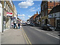
Your lifestyle in PE19 1JA relies on several key amenities located within practical reach. You have five retail options nearby, including Morrisons Daily, Waitrose, and M&S. These named stores provide access to groceries, clothing, and daily necessities without a long commute. Staying within the immediate vicinity means errands are quick and straightforward. A single rail option serves the area, with St Neots Railway Station located close by. This station acts as a primary transport link for commuters travelling beyond the immediate neighbourhood. The combination of fresh food availability and direct rail access defines the daily rhythm of life here. You can buy your lunch online or head to the station to travel. Museums such as the Rose Theatre historically define the wider Neots character, offering cultural events for residents. Nearby leisure and dining choices, while specific to the postcode vicinity, ensure you rarely travel far for a meal or a walk. The presence of supermarkets like Waitrose suggests a neighbourhood that values convenience and quality shopping. Residents benefit from a shopping-friendly environment where daily tasks are easy to manage. This blend of retail and transport infrastructure creates a practical living environment for busy households.
Amenities
Schools
| Rank | School | Type | Entry gender | Ages |
|---|
Explore more schools in this area
Go to Schools tabDemographics
The community in PE19 1JA is shaped by a mature population profile. The median age sits at 47, with adults aged between 30 and 64 years forming the most common demographic group. This age distribution suggests the neighbourhood attracts older professionals, empty-nesters, or families with children who have left school. Almost half of the residents own their homes, with exactly 43% of the population holding this status. The remaining residents likely rent or share accommodation. The predominant ethnic group in the area is White, reflecting a traditional demographic composition common in parts of the Neots. Housing stock in this postcode consists primarily of flats. This building type aligns with the high density of the area and suits the established age profile well. The combination of flat living and a high proportion of adults creates a settled, non-student community. You will find a neighbourhood where long-term residents dominate the street listings. This demographic stability often leads to quieter streets and established routines. However, the uniform age range means the area lacks young families or teenagers. If you seek a mix of generations, this specific snapshot of PE19 1JA does not offer a broad spectrum of age groups.
Household Size
Accommodation Type
Tenure
Ethnic Group
Religion
Household Composition
Age
Household Deprivation
NS-SEC
Explore more demographic insights in this area
Go to Demographics tabPlanning
Planning Constraints
- Flood RiskPremium
- Ramsar Wetland SitesPremium
- Area of Outstanding Natural BeautyPremium
- Protected Nature ReservePremium
- Protected WoodlandPremium