Area Overview for NR7 0TQ
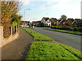
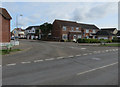
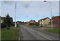
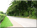
Photos of NR7 0TQ

Area Information
NR7 0TQ is a tightly defined residential cluster covering just 2.4 hectares, making it a compact settlement rather than a sprawling neighbourhood. With a population of 2004, the community maintains an intimate scale where residents likely know their neighbours by sight. You will find the postcode area sits at a population density of 1783 people per square kilometre, indicating a built environment where housing is relatively concentrated without being overwhelming. Living in NR7 0TQ means embracing a setting that balances residential density with proximity to larger town facilities. The area serves as a distinct micro-community within the broader Norfolk landscape, offering a sense of established stability. This specific postcode represents a complete residential unit where daily life revolves around routine local interactions rather than the anonymity of large urban estates. Prospective buyers are looking at a space that retains its character as a true housing cluster. The small footprint ensures that the environment remains manageable, avoiding the issues associated with high-rise living or sprawling suburban developments.
- Area Type
- Postcode
- Area Size
- 2.4 hectares
- Population
- 2004
- Population Density
- 1783 people/km²
Homes in NR7 0TQ reflect a classic rural English market characterising owner-occupied districts. The data shows 74 percent of the population owns their homes outright or with a mortgage, while only 26 percent rent. This high ownership figure signals a property market where residents prioritize buying over renting, likely due to the area's established nature and limited rental stock. The accommodation type breaks down almost entirely into houses, meaning you will not encounter high streets full of landladies or modern apartment blocks. This housing stock typically comprises semi-detached or detached properties built for families, which aligns with the median age of 47 years. For a buyer viewing this postcode, the competition will come from other owners looking to relocate rather than institutional landlords seeking tenants. The small area size of 2.4 hectares limits new development potential, preserving the existing character of the neighbourhood. When searching for properties in NR7 0TQ, expect to deal with standard house sales rather than the unique complexities of leasehold flats or new-build developments. The stability of the ownership base also suggests a community that values the long-term integrity of their homes.
House Prices in NR7 0TQ
Showing 61 properties
| Address | Type | Beds | Baths | Last Sale Price | Last Sale Date | |
|---|---|---|---|---|---|---|
| 60 Association Way, Thorpe St Andrew, NR7 0TQ | Detached | 3 | 1 | £275,000 | Dec 2025 | |
| 14 Association Way, Thorpe St Andrew, NR7 0TQ | Terraced | 1 | 1 | £170,000 | Sep 2025 | |
| 56 Association Way, Thorpe St Andrew, NR7 0TQ | Terraced | 1 | 1 | £190,000 | May 2025 | |
| 45 Association Way, Thorpe St Andrew, NR7 0TQ | Detached | 3 | 2 | £293,000 | Oct 2024 | |
| 4 Association Way, Thorpe St Andrew, NR7 0TQ | Detached | 4 | 3 | £348,000 | Aug 2023 | |
| 31 Association Way, Thorpe St Andrew, NR7 0TQ | Detached | 4 | 2 | £415,000 | Mar 2023 | |
| 55 Association Way, Thorpe St Andrew, NR7 0TQ | house | - | - | £270,000 | Nov 2022 | |
| 54 Association Way, Thorpe St Andrew, NR7 0TQ | Terraced | 1 | - | £185,000 | May 2022 | |
| 1 Association Way, Thorpe St Andrew, NR7 0TQ | Detached | 3 | 1 | £340,000 | Sep 2021 | |
| 33 Association Way, Thorpe St Andrew, NR7 0TQ | house | - | - | £315,000 | Jun 2021 |
Energy Efficiency in NR7 0TQ
Daily life in NR7 0TQ is supported by a ring of practical amenities within easy reach. Retail options include Sainsburys Pound, Makro Norwich, and the East of England Co-operative Co, ensuring you have access to food and household supplies without needing to travel far. These shops provide the essentials for a self-sufficient household, from bulk groceries to weekly provisions. Travel connections are robust, with five railway stations including Norwich Railway Station, Brundall Gardens Railway Station, and Salhouse Railway Station located nearby. This network gives you flexibility when choosing a commute or planning a weekend break away from home. Norwich International Airport provides further connectivity for regional visits or international work travel. Wroxham serves as a local hub for additional services and leisure activities, adding variety to your weekly routine. Living in NR7 0TQ means you have a village feel but access to town-level convenience. The mix of supermarkets, train services, and airport access creates a balanced lifestyle that avoids the extremes of urban clutter or rural isolation.
Amenities
Schools
| Rank | School | Type | Entry gender | Ages |
|---|
Explore more schools in this area
Go to Schools tabDemographics
The demographic profile of NR7 0TQ shows a mature community with a median age of 47 years. Most residents fall within the adult age range of 30 to 64 years, suggesting the postcodes appear in households rather than student digs or retirement villages. This age distribution often correlates with families needing more space and stability for career progression. You will encounter a predominantly White ethnic minority group, which indicates the area retains a traditional demographic make-up common in long-settled parts of rural England. Homeownership stands at 74 percent, a figure that demonstrates strong property loyalty and financial investment by the local population. The high ownership rate points to a market where residents have stayed through market cycles rather than churning frequently as renters. Houses form the dominant accommodation type, confirming that terraced flats or purpose-built apartments are not the feature of this specific postcode. The absence of social housing indicators in the data suggests this is an area where private owners manage their own properties. This demographic stability contributes to a quiet, settled atmosphere where life pace depends on personal choice rather than transient work shifts.
Household Size
Accommodation Type
Tenure
Ethnic Group
Religion
Household Composition
Age
Household Deprivation
NS-SEC
Explore more demographic insights in this area
Go to Demographics tabPlanning
Planning Constraints
- Flood RiskPremium
- Ramsar Wetland SitesPremium
- Area of Outstanding Natural BeautyPremium
- Protected Nature ReservePremium
- Protected WoodlandPremium