Area Overview for NR33 8SN
Photos of NR33 8SN
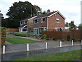
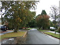
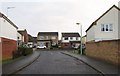
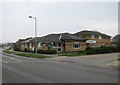

41 photos from this area
Area Information
Key information about the NR33 8SN including its size, population, and administrative classification.
- Area Type
- Postcode
- Area Size
- 1.7 hectares
- Population
- 1462
- Population Density
- 3142 people/km²
House Prices in NR33 8SN
28
Properties
£202,052
Average Sold Price
£85,995
Lowest Price
£365,000
Highest Price
Showing 28 properties
| Address | Type | Beds | Baths | Last Sale Price | Last Sale Date | |
|---|---|---|---|---|---|---|
| 14 Thistledown, Lowestoft, NR33 8SN | Detached | 4 | 1 | £242,000 | Nov 2017 | |
| 21 Thistledown, Lowestoft, NR33 8SN | Detached | 4 | 1 | £365,000 | Sep 2017 | |
| 10 Thistledown, Lowestoft, NR33 8SN | Bungalow | 3 | - | £325,000 | Aug 2017 | |
| 4 Thistledown, Lowestoft, NR33 8SN | Detached | 4 | 1 | £305,000 | Aug 2017 | |
| 1 Thistledown, Lowestoft, NR33 8SN | Bungalow | - | - | £185,000 | May 2017 | |
| 22 Thistledown, Lowestoft, NR33 8SN | house | - | - | £210,000 | Oct 2015 | |
| 5 Thistledown, Lowestoft, NR33 8SN | Bungalow | 3 | 1 | £153,500 | Aug 2015 | |
| 20 Thistledown, Lowestoft, NR33 8SN | Detached | 3 | - | £192,000 | Jun 2015 | |
| 6 Thistledown, Lowestoft, NR33 8SN | Detached | 6 | 1 | £273,000 | May 2015 | |
| 16 Thistledown, Lowestoft, NR33 8SN | house | - | - | £205,000 | Oct 2013 |
Page 1 of 3
Energy Efficiency in NR33 8SN
Amenities
Schools
| Rank | School | Type | Entry gender | Ages |
|---|
Explore more schools in this area
Go to Schools tabDemographics
Household Size
Two person
most common
Accommodation Type
Houses
most common
Tenure
93
majority
Ethnic Group
White
most common
Religion
N/A
most common
Household Composition
N/A
most common
Age
47
median
Adults (30-64 years)
most common
Household Deprivation
N/A
with no deprivation
NS-SEC
33
in Lower managerial occupations
Explore more demographic insights in this area
Go to Demographics tabPlanning
Planning Constraints
- Flood RiskPremium
- Ramsar Wetland SitesPremium
- Area of Outstanding Natural BeautyPremium
- Protected Nature ReservePremium
- Protected WoodlandPremium