Area Overview for NR33 8LH
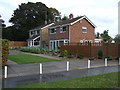
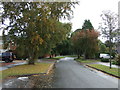
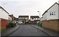
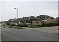
Photos of NR33 8LH


Area Information
NR33 8LH is a specific postcode area covering a small residential cluster with a total size of 6,704 square metres. You will find 1,462 residents calling this location home, creating a tightly knit community where neighbours know one another. The population density stands at 218,084 people per square kilometre, a figure that reflects the concentrated nature of this residential pocket. Despite the high density metric, the area functions as a contained residential cluster rather than a sprawling urban zone. Daily life here revolves around proximity and local connection. You do not need to travel far for your supermarkets, train stations, or community hubs. The area includes Oulton Broad to the east and Beccles to the south, providing context to its location within Norfolk. Homes in NR33 8LH benefit from immediate access to Oulton Broad South Railway Station and major retail chains like Tesco Oulton. You can expect a settled environment where the layout prioritises quiet living over commercial expansion. This postcode serves as your entry point into a stable neighbourhood with established infrastructure. Living in NR33 8LH means choosing a location defined by its compact footprint and strategic position relative to nearby transport links.
- Area Type
- Postcode
- Area Size
- 6704 m²
- Population
- 1462
- Population Density
- 3142 people/km²
NR33 8LH operates as a firmly owner-occupied market with 93% of residents holding title to their homes. This statistic indicates a very high level of stability compared to national rental markets or university towns. The entire accommodation type mix consists of houses, meaning you will not encounter flats or maisonettes when viewing properties. This structure appeals to buyers seeking detached or semi-detached family homes rather than urban-style living. The low volume of 1,462 residents within 6,704 square metres limits active market turnover. You will find fewer listings available at any one time compared to larger urban postcodes. The area functions as a quiet residential cluster where property values remain steady. If you are looking to buy homes in NR33 8LH, you should expect a straightforward transaction involving private owners. Rental alternatives are rare due to the overwhelming ownership percentage. The presence of only houses ensures consistent property types, which simplifies valuation and comparison. Buyers do not need to manage diverse tenancies or variable building standards. The market reflects a community that has prioritised home ownership over investment rentals. This environment may suit those who value long-term security in their purchase.
House Prices in NR33 8LH
Showing 11 properties
| Address | Type | Beds | Baths | Last Sale Price | Last Sale Date | |
|---|---|---|---|---|---|---|
| 4 Wheatfield Road, Lowestoft, NR33 8LH | Bungalow | - | - | £225,000 | Jun 2021 | |
| 2 Wheatfield Road, Lowestoft, NR33 8LH | house | - | - | £190,000 | May 2017 | |
| 7 Wheatfield Road, Lowestoft, NR33 8LH | Detached | 4 | 2 | £241,500 | Feb 2016 | |
| 3 Wheatfield Road, Lowestoft, NR33 8LH | Detached | - | - | £127,000 | May 2012 | |
| 10 Wheatfield Road, Lowestoft, NR33 8LH | house | - | - | £170,000 | Aug 2009 | |
| 11 Wheatfield Road, Lowestoft, NR33 8LH | Detached | - | - | £175,000 | Jul 2007 | |
| 5 Wheatfield Road, Lowestoft, NR33 8LH | Detached | - | - | £124,000 | Nov 2004 | |
| 1 Wheatfield Road, Lowestoft, NR33 8LH | Detached | - | - | £129,995 | Apr 2004 | |
| 6 Wheatfield Road, Lowestoft, NR33 8LH | Detached | - | - | £135,000 | Jan 2003 | |
| 9 Wheatfield Road, Lowestoft, NR33 8LH | Detached | - | - | £67,995 | Apr 1999 |
Energy Efficiency in NR33 8LH
Your daily lifestyle in NR33 8LH centres on practical amenities within easy reach. You are five minutes from Co-op Carlton and Co-op Pinewood for your weekly grocery shopping. Tesco Oulton serves as a major retail hub just a short drive away. Never need to travel far for fresh food or household essentials. Five railway entrances provide access points to the rail network, with Oulton Broad South Railway Station being the most prominent. You can reach Weybourne or Holt train stations quickly for broader network access. Beccles Airport lies nearby if you plan private aviation travel. The area offers convenient access without the chaos of a city centre. Your commute times will remain predictable because the route includes Oulton Broad South Railway Station directly. Shopping trips fit easily into your weekend plans thanks to the Co-op branches. You will find that living in NR33 8LH balances convenience with a calm, suburban pace. The presence of multiple transport hubs means you are never isolated from the rest of Norfolk.
Amenities
Schools
| Rank | School | Type | Entry gender | Ages |
|---|
Explore more schools in this area
Go to Schools tabDemographics
The community in NR33 8LH is defined by a median age of 47 years. Most residents fall into the adult demographic between 30 and 64 years old. This age profile suggests a neighbourhood established by families and longer-term settled households. You will encounter very few young children or elderly residents in the immediate statistical data. Home ownership is the dominant tenure model, with 93% of properties owned outright or with a mortgage. Only 7% of homes sit in the rental sector. Houses make up the entire accommodation type mix for this postcode. You will not find flat conversions or purpose-built rental blocks here. The predominant ethnic group is White, reflecting the traditional demographic makeup of many Norfolk settlements. This lack of diversity is a factual aspect of the current population structure. The area does not show signs of rapid demographic shifts or migration. If you value stability and permanent residents, the 93% ownership rate confirms this area suits that preference. The absence of student accommodation or transient populations means the local environment remains consistent year-round. Your neighbours are likely to have lived in the area for a significant period.
Household Size
Accommodation Type
Tenure
Ethnic Group
Religion
Household Composition
Age
Household Deprivation
NS-SEC
Explore more demographic insights in this area
Go to Demographics tabPlanning
Planning Constraints
- Flood RiskPremium
- Ramsar Wetland SitesPremium
- Area of Outstanding Natural BeautyPremium
- Protected Nature ReservePremium
- Protected WoodlandPremium