Area Overview for NR33 8LJ
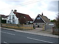
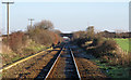
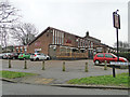
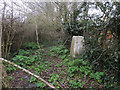
Photos of NR33 8LJ


Area Information
The postcode NR33 8LJ defines a compact residential cluster covering an area of 6696 square metres within Norfolk, England. This specific location accommodates a population of 1462 residents, creating a tightly knit community environment. The high density of 218349 people per square kilometre reflects the intensive nature of this postcode, which is designed as a focused residential zone rather than a sprawling suburb. Living in NR33 8LJ means navigating a space where daily interactions with neighbours are likely frequent due to the restricted footprint. The area serves as a defined node within the wider local network, offering a contained living experience. Prospective buyers view this space as a specific residential cluster rather than a broad neighbourhood, understanding that the 1462 households live within a clearly bounded geographic limit. The small size ensures that the character of the area remains consistent across the postcode boundary. You can expect a grounded reality where the distinctiveness comes from its definition as a precise residential unit within the county system.
- Area Type
- Postcode
- Area Size
- 6696 m²
- Population
- 1462
- Population Density
- 218349 people/km²
The property market in NR33 8LJ is defined by a overwhelmingly owner-occupied landscape. A survey of the area reveals that 93% of households are owner-occupied, leaving only a tiny fraction of residents renting their homes. This statistic indicates a market where buyers have typically stayed for the long term, building equity and settling into the local rhythm. Houses constitute the primary accommodation type, meaning you will not find the high-rise flats or converted apartments common in urban regeneration zones. The housing stock is tailored to the specific needs of adults and families who value the security of ownership. Given the total population of 1462 within 6696 square metres, the physical availability of homes is fixed within this small footprint. Buyers looking at NR33 8LJ approach the market knowing they are entering an established territory where current residents have already invested heavily in their properties.
House Prices in NR33 8LJ
Showing 3 properties
| Address | Type | Beds | Baths | Last Sale Price | Last Sale Date | |
|---|---|---|---|---|---|---|
| 2 Ashburnham Way, Lowestoft, NR33 8LJ | Detached | 3 | - | £149,000 | Nov 2014 | |
| Uplands Children Centre, Ashburnham Way, Lowestoft, NR33 8LJ | commercial | - | - | - | - | |
| Uplands Community Centre And Playing Field, Ashburnham Way, Lowestoft, NR33 8LJ | community_day_centre | - | - | - | - |
Energy Efficiency in NR33 8LJ
Daily life in NR33 8LJ is supported by a set of practical amenities located within practical reach of the residential cluster. Local retail options include Co-op Carlton, Tesco Oulton, and Co-op Pinewood, providing residents with immediate access to groceries and daily essentials. For transport and travel needs, the nearby rail network includes stations such as Entrance3, Entrance1, and Oulton Broad South Railway Station, facilitating regional connections. Travelers can also utilise Beccles Airport, which serves as a local aviation facility. These five retail outlets and five rail access points create a functional hub for residents. You do not need to travel far for basic shopping or transport planning. The presence of these specific venues grounds the lifestyle of those living in NR33 8LJ, ensuring that daily errands and regional commutes remain manageable without requiring long journeys into central urban centres.
Amenities
Schools
| Rank | School | Type | Entry gender | Ages |
|---|
Explore more schools in this area
Go to Schools tabDemographics
The community in NR33 8LJ is characterised by a mature demographic profile with a median age of 47 years. Adults aged between 30 and 64 years represent the most common age range for residents here. This age distribution indicates that the area attracts families and individuals established in their careers. Home ownership stands at an exceptionally high level of 93%, confirming that the vast majority of households own their properties outright or with significant equity. Houses remain the predominant form of accommodation, aligning with the preferences of this older, established population. The population maintains a predominantly white ethnic composition. The combination of high home ownership and a median age of 47 suggests a stable residential base. You will find few young professionals or transient students within this immediate cluster. The demographic structure supports a neighbourhood focused on stability rather than rapid change or turnover.
Household Size
Accommodation Type
Tenure
Ethnic Group
Religion
Household Composition
Age
Household Deprivation
NS-SEC
Explore more demographic insights in this area
Go to Demographics tabPlanning
Planning Constraints
- Flood RiskPremium
- Ramsar Wetland SitesPremium
- Area of Outstanding Natural BeautyPremium
- Protected Nature ReservePremium
- Protected WoodlandPremium