Area Overview for NR33 0PQ
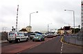
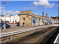
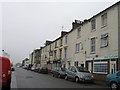
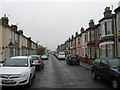
Photos of NR33 0PQ

Area Information
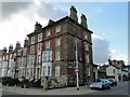
Living in NR33 0PQ means residing in a specific postcode area comprising a small residential cluster. You are in a compact community spanning just 7501 square metres, home to 1598 people. The neighbourhood is defined by its density, with a population density of 213028 people per square kilometre. This high density suggests a built-up environment where properties are closely situated. Despite the small size, the area provides a complete home for its 1598 residents. Daily life here revolves around a shared, concentrated space rather than sprawling suburbs. The area functions efficiently due to its limited footprint. You will find that your immediate surroundings are part of this tight-knit cluster. The location offers a distinct experience compared to wider neighbourhoods. It stands out as a focused residential zone within the broader region. Understanding this layout helps you visualise your potential move to this postcode. The combination of space efficiency and resident concentration shapes the character of NR33 0PQ.
- Area Type
- Postcode
- Area Size
- 7501 m²
- Population
- 1598
- Population Density
- 213028 people/km²
The property market in NR33 0PQ is characterised by a predominance of flats. Only 25% of the population owns their homes outright. This statistic highlights that the majority of the 1598 residents live in rented properties. The housing stock focuses on flat units rather than standalone houses. This configuration suits the small area size of 7501 square metres. Buyers looking at this postcode will find a rental market with a smaller share of owner-occupied stock. The high density of 213028 people per square kilometre supports this flat-heavy model. You must consider that nearly 75% of residents are tenants. Ownership rates here sit significantly lower than average suburban benchmarks. This dynamic means competition for ownership opportunities might be intense relative to the supply. Flats dominate the landscape, catering to the adult demographic aged 30 to 64 years. Understanding this 25% ownership figure is crucial for anyone assessing long-term living costs or investment potential in NR33 0PQ.
House Prices in NR33 0PQ
Showing 61 properties
Energy Efficiency in NR33 0PQ
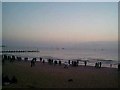
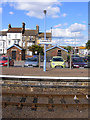
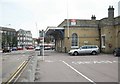
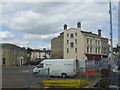
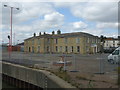
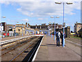
Daily life in NR33 0PQ benefits from immediate access to key amenities within practical reach. Five retail outlets operate near the postcode, including Asda Lowestoft, M&S Lowestoft, and Iceland Lowestoft. You can carry out essential shopping trips without extensive travel. Five rail stations including Entrance, Lowestoft Railway Station, and Oulton Broad North Railway Station serve the community. These transport hubs connect you to wider networks efficiently. Beccles Airport, located within reach of this housing cluster, offers additional travel flexibility. The presence of these 5 major retailers and 1 airport facility shapes the convenience of your day-to-day routine. Residents do not need to travel far for groceries or general goods. The rail network provides straightforward access for commuting or leisure. This proximity to commercial and transport nodes is a defining feature of the lifestyle in NR33 0PQ. You gain the practical benefits of a larger city centre without the distance. The specific naming of Asda, M&S, and Iceland anchors the retail experience for locals.
Amenities
Schools
| Rank | School | Type | Entry gender | Ages |
|---|
Explore more schools in this area
Go to Schools tabDemographics
The community in NR33 0PQ reflects a mature population profile with a median age of 47. Most residents fall into the adults category, specifically those aged between 30 and 64 years. This age group forms the backbone of the local population. Home ownership accounts for 25% of households, indicating a significant portion lives in rented accommodation. Flats represent the predominant accommodation type within this cluster. The population remains predominantly White, which reflects the current demographic composition of the area. These figures suggest a stable, established community with specific housing and age characteristics. The high density and flat-type housing often correlate with the adult age profile observed. Buyers should note that three-quarters of residents do not own their homes outright. This ratio influences the local market dynamics and rental demand. The concentration of adults in the 30 to 64 bracket defines the social fabric of NR33 0PQ. Demographic data confirms a defined group of middle-aged adults living primarily in flat units.
Household Size
Accommodation Type
Tenure
Ethnic Group
Religion
Household Composition
Age
Household Deprivation
NS-SEC
Explore more demographic insights in this area
Go to Demographics tabPlanning
Planning Constraints
- Flood RiskPremium
- Ramsar Wetland SitesPremium
- Area of Outstanding Natural BeautyPremium
- Protected Nature ReservePremium
- Protected WoodlandPremium