Area Overview for NR26 8DT
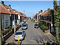
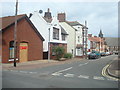
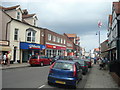
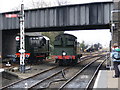
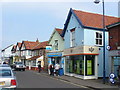
Photos of NR26 8DT
Area Information
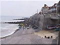
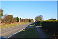
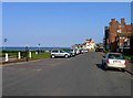
The postcode area NR26 8DT represents a compact residential cluster in Norfolk, covering exactly 4206 square metres. Although the land footprint is small, it sustains a population of 1752 people, resulting in a population density of 1503 inhabitants per square kilometre. This density indicates a relatively close-knit neighbourhood where residents live in proximity to one another. The area sits within the NR26 postcode region, which typically serves the Sheringham and Weybourne line of the Norfolk coast. Daily life here unfolds within a defined boundary that balances residential priority with access to wider transport networks. You will find that this specific location acts as a contained community while remaining connected to broader services found in nearby towns like Sheringham and Cromer. The high population density suggests limited street space per household, which can mean busy roads and a vibrant street presence despite the small physical size of the enclave. Prospective homebuyers should understand that living in NR26 8DT means residing in a dense, established pocket of Norfolk rather than a sprawling new development. The area's identity is firmly rooted in its status as a specific residential postcode with clearly defined boundaries and a stable resident base.
- Area Type
- Postcode
- Area Size
- 4206 m²
- Population
- 1752
- Population Density
- 1503 people/km²
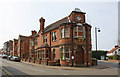
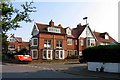
The housing stock in NR26 8DT is defined by a strong preference for houses rather than flats, reflecting the preferences of homeowners who make up 61 per cent of the population. This balance between owner-occupiers and other tenure types indicates a stable market where many residents have purchased their homes to stay long term. As a small residential cluster, the area is not a large estate but a focused group of properties that likely share similar architectural styles and age profiles. When searching for homes in NR26 8DT, you will find that the market is characterised by detached or semi-detached houses suited to families living through their middle and retirement years. The low density of flat listings corresponds with the high percentage of households that value private gardens and single-story layouts. This specific postcode area does not cater to high-density living, making it an unsuitable option for those seeking urban apartment living. Instead, it offers a traditional suburban experience with established estates. Residents here are far more likely to be mortgage holders or outright owners than private renters. This stability benefits the local property market by reducing turnover and maintaining consistent neighbourhood values.
House Prices in NR26 8DT
Showing 12 properties
| Address | Type | Beds | Baths | Last Sale Price | Last Sale Date | |
|---|---|---|---|---|---|---|
| Flat 1, 50 High Street, Sheringham, NR26 8DT | Flat | - | - | - | - | |
| The Mews, 46A High Street, Sheringham, NR26 8DT | house | - | - | - | - | |
| Flat 2, Ashanti House, 52 High Street, Sheringham, NR26 8DT | Flat | - | - | - | - | |
| Flat 1, Ashanti House, 52 High Street, Sheringham, NR26 8DT | Flat | - | - | - | - | |
| 42A High Street, Sheringham, NR26 8DT | Maisonette | - | - | - | - | |
| 48 High Street, Sheringham, NR26 8DT | Maisonette | - | - | - | - | |
| Crofters Restaurant, 32 High Street, Sheringham, NR26 8DT | restaurant_cafe | - | - | - | - | |
| The Sheringham Trawler, 50 High Street, Sheringham, NR26 8DT | restaurant_cafe | - | - | - | - | |
| The Sheringham Trawler, 50A High Street, Sheringham, NR26 8DT | Restaurant | - | - | - | - | |
| Flat 3, 36 High Street, Sheringham, NR26 8DT | Flat | - | - | - | - |
Energy Efficiency in NR26 8DT
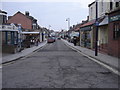
Residents of NR26 8DT enjoy convenient access to essential retail and transport links despite the small size of the immediate cluster. Within practical reach, you will find three major supermarkets: Sainsburys Sheringham, Tesco Sheringham, and Budgens Sheringham. These stores form the backbone of daily shopping, offering grocery supplies and household essentials without forcing long commutes to larger city centres. The area also benefits from four railway stations nearby, including Sheringham, West Runton, Cromer, and Holt stations. Sheringham serves as the primary local hub, providing direct through-trains to Norwich and the London Euston line. Two metro regions, Weybourne and Holt, offer additional connectivity for those accessing wider Norfolk services. You can easily integrate your daily life around these transport nodes, using Sheringham for most shopping trips and Cromer for weekend excursions. The presence of multiple supermarkets ensures that your weekly shop is never more than a few minutes away. This blend of local convenience and regional rail access makes NR26 8DT a practical choice for those who value both home comfort and mobility.
Amenities
Schools
| Rank | School | Type | Entry gender | Ages |
|---|
Explore more schools in this area
Go to Schools tabDemographics
The community profile of NR26 8DT reveals an older demographic, with a median age of 47 years. The most common age range among residents falls within the elderly category of 65 years or older, indicating a significant proportion of retired homeowners live here. This age distribution shapes the social fabric, creating a neighbourhood where retirees and older families dominate the resident population. Home ownership stands at a robust 61 per cent, suggesting that many families have settled over a long period rather than being transient renters. The predominant accommodation type consists of houses, which aligns with the preferences of older buyers seeking single-family dwellings over flat-led developments. The area is predominantly White, reflecting a homogenous community structure typical of many rural English suburbs. You will not find significant youth population shifts here, as the median age pulls heavily towards mature demographics. This demographic profile stabilises the local market and often results in lower crime rates. The concentration of elderly residents means that lifestyle amenities often cater to quieter, settled living patterns. Houses remain the primary choice for accommodation, reinforcing the area's character as a traditional, family-owned estate rather than a student or young professional hub.
Household Size
Accommodation Type
Tenure
Ethnic Group
Religion
Household Composition
Age
Household Deprivation
NS-SEC
Explore more demographic insights in this area
Go to Demographics tabPlanning
Planning Constraints
- Flood RiskPremium
- Ramsar Wetland SitesPremium
- Area of Outstanding Natural BeautyPremium
- Protected Nature ReservePremium
- Protected WoodlandPremium