Area Overview for NR20 4WE
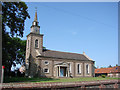
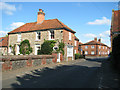
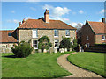
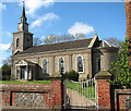
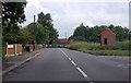
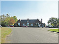
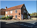
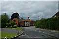
Photos of NR20 4WE
Area Information
Living in NR20 4WE means residing within a compact residential cluster defined by postcode NR20 4WE. This specific area covers 2,928 square metres, making it a small, defined locality rather than a sprawling district. You will find a close-knit environment where 2,468 people call this space home. The population density stands at 74 people per square kilometre, creating a setting that feels settled and established rather than chaotic or rapidly growing. The presence of so many adults in the 30 to 64 age range suggests a neighbourhood built for stability and long-term residency. Daily life here revolves around a manageable community scale where residents know their immediate surroundings. You are looking at an area where the built environment supports a traditional way of living without the noise or congestion often found in larger towns. The distinct character of NR20 4WE comes from its focus on housing stability and quiet residential streets. Prospective buyers see this postcode as a practical choice for families or individuals seeking a grounded community. The small size of the area ensures that services are nearby, yet the population remains cohesive. This balance makes NR20 4WE a straightforward option for those who prefer a smaller footprint for their home search.
- Area Type
- Postcode
- Area Size
- 2928 m²
- Population
- 2468
- Population Density
- 74 people/km²
Buying homes in NR20 4WE takes you into a market defined by stability and tenure. The figure shows 78 per cent home ownership within the postcode, meaning the vast majority of properties are privately owned. Most residents have secured their own homes rather than living as tenants in the social or private rental sectors. The predominant accommodation type is houses, which means you will not find flats or terraced housing as the mainstock. This landscape is typical of areas established for long-term family living rather than temporary housing solutions. If you are looking at NR20 4WE, you are entering a market where sellers are owners looking to move, not landlords cycling through short-term rentals. The small geographic size of 2,928 square metres limits the total number of properties available for sale, which can make looking around the area a concentrated exercise. You might see fewer listings in a single month compared to a major city. The high ownership rate suggests that when a property does come to the market, it is often a mature individual or family selling up. This steadiness provides predictability for buyers who want to avoid the volatility of a pure rental market.
House Prices in NR20 4WE
Showing 10 properties
| Address | Type | Beds | Baths | Last Sale Price | Last Sale Date | |
|---|---|---|---|---|---|---|
| 11 Greenhouse Road, Bawdeswell, NR20 4WE | Semi-detached | 2 | 1 | £115,000 | Jul 2024 | |
| 1 Greenhouse Road, Bawdeswell, NR20 4WE | house | - | - | £365,000 | Dec 2020 | |
| 9 Greenhouse Road, Bawdeswell, NR20 4WE | house | - | - | £210,000 | Sep 2020 | |
| 7 Greenhouse Road, Bawdeswell, NR20 4WE | house | - | - | £210,000 | Mar 2020 | |
| 5 Greenhouse Road, Bawdeswell, NR20 4WE | house | - | - | £210,000 | Feb 2020 | |
| 3 Greenhouse Road, Bawdeswell, NR20 4WE | house | - | - | £295,000 | Feb 2020 | |
| 13 Greenhouse Road, Bawdeswell, NR20 4WE | Flat | - | - | - | - | |
| 15 Greenhouse Road, Bawdeswell, NR20 4WE | Flat | - | - | - | - | |
| 19 Greenhouse Road, Bawdeswell, NR20 4WE | Flat | - | - | - | - | |
| 17 Greenhouse Road, Bawdeswell, NR20 4WE | Flat | - | - | - | - |
Energy Efficiency in NR20 4WE
Daily life for residents of NR20 4WE benefits from a cluster of amenities located within practical reach. You can visit Morrisons Daily, Budgens Lenwade, and Spar for everyday shopping requirements, providing a choice of three main retail outlets nearby. These superstores cover your weekly groceries and essential household needs without requiring a long journey into the nearest town. The postcode also has access to Dersham railway station or Dudley station depending on the specific route, though the data notes Dereham as the nearest metro station option, implying a short train ride is sufficient for larger travel needs. While dining and leisure venues are not explicitly listed in the immediate amenity data, the presence of these retail hubs ensures essentials are never far away. The small area size of 2,928 square metres means these services are dense enough to impact daily convenience significantly. You will find that a simple trip across the county or a day out is easily reached by car or public transport via Dereham. This setup supports a lifestyle where you handle local necessities independently while reserving longer trips for weekend activities. The combination of three major supermarkets and rail access creates a functional, self-sufficient environment for the 2,468 people living here.
Amenities
Schools
Families considering NR20 4WE have several educational options immediately nearby, though the selection is focused on primary levels. The Tutorial Centre operates in the area, though it functions as a different type of educational facility rather than a traditional school. For compulsory education, you have access to Bawdeswell Community Primary School and Lyng Church of England Primary School. Bawdeswell Community Primary School carries an Ofsted rating of good, which provides a level of quality assurance for parents. Lyng Church of England Primary Academy is also listed as a nearby option for young children. The mix includes both community-run institutions and faith-based academies, offering some variety in ethos while remaining within the local sphere. There are no secondary schools listed in the immediate vicinity of the postcode, meaning older children will likely commute to schools further away. This structure suggests that NR20 4WE serves as a residential catchment for younger children while providing stability for families planning their long-term education needs. The proximity of Bawdeswell and Lyng ensures that the early years of schooling are managed locally without long travel times.
| Rank | School | Type | Entry gender | Ages |
|---|
Explore more schools in this area
Go to Schools tabDemographics
The community within NR20 4WE is heavily dominated by adults between 30 and 64 years of age, with a median age of 47. This age profile indicates a mature, established population likely residing in the area for significant periods. You will notice that 78 per cent of residents own their homes, pointing to a very strong culture of home ownership rather than renting. This high level of ownership contributes to the stable character of the neighbourhood. The dominant accommodation type is houses, which aligns perfectly with the home ownership statistics and the age of the residents. Ethnically, the predominant group is White, reflecting the broader demographic trends of the region. The housing stock consists almost exclusively of houses, excluding high-rise apartments or large social housing blocks. This mix of factors creates a neighbourhood that values tradition and permanence. There are no transient populations disrupting the social fabric, as evidenced by the consistent home ownership rate. If you are looking for a community where neighbours know one another, the adult age range and high ownership rates in NR20 4WE offer exactly that environment. The demographic data confirms this is a place for stability.
Household Size
Accommodation Type
Tenure
Ethnic Group
Religion
Household Composition
Age
Household Deprivation
NS-SEC
Explore more demographic insights in this area
Go to Demographics tabPlanning
Planning Constraints
- Flood RiskPremium
- Ramsar Wetland SitesPremium
- Area of Outstanding Natural BeautyPremium
- Protected Nature ReservePremium
- Protected WoodlandPremium