Area Overview for NR10 3JF
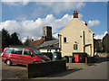
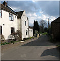
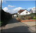
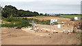
Photos of NR10 3JF

Area Information
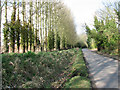
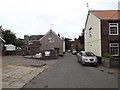
Living in NR10 3JF means residing in a specific postcode area that covers a small residential cluster. This defined zone spans 90.1 hectares and hosts a population of 1792 residents. The density stands at 245 people per square kilometre, creating a settlement that feels contained rather than sprawling. You are part of a community where daily life revolves around a neighbourhood with clear boundaries and a manageable scale. Residents enjoy a sense of locality within this compact footprint in Norfolk. Daily routines centre on local streets and access to the wider networks of the surrounding region. The area maintains a distinct character separate from larger urban centres. You live in a space where proximity to neighbours and local amenities defines the community feel. This residential cluster offers a straightforward environment for those seeking a home in a smaller setting. The area is situated in England, providing a stable context for your living situation. Your address here places you firmly within a recognised residential pocket.
- Area Type
- Postcode
- Area Size
- 90.1 hectares
- Population
- 1792
- Population Density
- 245 people/km²
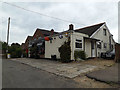
Looking at the property market in NR10 3JF, the data indicates a predominantly owner-occupied environment. Seven out of every ten households own their home, suggesting that buying rather than renting is the norm. The accommodation type data confirms that houses are the standard dwelling structure. You will not find a concentration of flats or purpose-built apartments in this small area. This housing stock suits buyers seeking permanence and attachment to a specific location. The market here is geared towards individuals and families purchasing homes for longer-term stays. Selling in this postcode area may suit those who own rather than investors seeking high rental turnover. The volume of properties is limited given the small population size of 1792, so choices will be fewer than in larger towns. This reality means you should act quickly if you decide to purchase a home here. The high ownership rate reflects a community where residents stay.
House Prices in NR10 3JF
Showing 11 properties
| Address | Type | Beds | Baths | Last Sale Price | Last Sale Date | |
|---|---|---|---|---|---|---|
| 154 Old Norwich Road, Horsham St Faith, NR10 3JF | Bungalow | 2 | 1 | £275,000 | Aug 2013 | |
| 156 Old Norwich Road, Horsham St Faith, NR10 3JF | Detached | - | - | £154,000 | Nov 2002 | |
| 144 Old Norwich Road, Horsham St Faith, NR10 3JF | Detached | 5 | 2 | £131,000 | Jul 1996 | |
| 158 Old Norwich Road, Horsham St Faith, NR10 3JF | Detached | - | - | £57,500 | Apr 1996 | |
| 150 Old Norwich Road, Horsham St Faith, NR10 3JF | Detached | - | - | £75,000 | Jul 1995 | |
| Edgehill, 146 Old Norwich Road, Horsham St Faith, NR10 3JF | Detached | 5 | 2 | - | - | |
| Bowling Green, Blind Lane, Horsham St Faith, NR10 3JF | Leisure | - | - | - | - | |
| 142 Old Norwich Road, Horsham St Faith, NR10 3JF | Detached | - | - | - | - | |
| The Beeches, 140 Old Norwich Road, Horsham St Faith, NR10 3JF | Detached | - | - | - | - | |
| Sams Souci, 152 Old Norwich Road, Horsham St Faith, NR10 3JF | Semi-detached | - | - | - | - |
Energy Efficiency in NR10 3JF
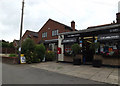
Residents of NR10 3JF enjoy access to a range of amenities within practical reach. Five notable retail categories are nearby, including Tesco Norwich and the East of England Co-operative Co for shopping needs. Three railway stations and one metro point in Wroxham offer connections to broader travel networks. You can reach Norwich International Airport easily if business travel is part of your lifestyle. These facilities support a balanced daily routine without requiring long commutes into the city centre. Supermarkets provide essentials for food and household bills. The location of these shops means you can run errands efficiently while living in the smaller residential cluster. Access to rail links allows for occasional trips to the coast or historic towns.
Amenities
Schools
For families considering living in NR10 3JF, educational options are limited but include St Faiths CofE Primary School. This institution serves as a primary school for local children and holds a Good rating from Ofsted. The presence of a single primary school suggests that secondary education requires travel to a different town. You will rely on this specific school for primary-aged children before looking outside the immediate vicinity for secondary education. The Good rating indicates a standard of quality that meets government expectations. There are no secondary schools or alternative education providers listed within the data for this area. Parents must plan their children's education carefully, likely involving a commute to a larger nearby town for older students. The reliance on one primary institution defines the early schooling experience for families in this postcode.
| Rank | School | Type | Entry gender | Ages |
|---|
Explore more schools in this area
Go to Schools tabDemographics
The community in NR10 3JF reflects an established residential pattern with a median age of 47 years. Most residents fall into the adult age range between 30 and 64 years, indicating a mature demographic. Home ownership is high, with 72% of households owning their property outright or with a mortgage. Houses constitute the primary accommodation type for living in this area, meaning you will see detached or semi-detached properties rather than flats or apartments. The predominant ethnic group is White, aligning with the broader national trend for this district. These figures paint a picture of stability and long-term residency. Families and established professionals dominate the local population mix. The lack of students or young professionals suggests a quieter, perhaps more traditional lifestyle. You are likely to meet neighbours who have been in the area for a significant period. The demographic profile supports a community where social circles may form through long-standing local connections rather than transient influences.
Household Size
Accommodation Type
Tenure
Ethnic Group
Religion
Household Composition
Age
Household Deprivation
NS-SEC
Explore more demographic insights in this area
Go to Demographics tabPlanning
Planning Constraints
- Flood RiskPremium
- Ramsar Wetland SitesPremium
- Area of Outstanding Natural BeautyPremium
- Protected Nature ReservePremium
- Protected WoodlandPremium