Area Overview for NR10 3GX
Photos of NR10 3GX


Area Information
Living in NR10 3GX means residing within a specific postcode area that covers a small residential cluster. The entire zone spans 9481 square metres and accommodates a population of 1792 people. This density results in approximately 245 people per square kilometre, creating an environment that is neither overwhelmingly crowded nor dangerously isolated. You will find yourself in a setting where homes lie relatively close together, fostering a sense of proximity without sacrificing privacy. The layout supports a quiet domestic life while maintaining practical access to nearby towns and services. Residents here experience a balance between rural tranquillity and accessibility to broader regional hubs. The area does not suffer from congestion issues due to its modest footprint, yet it remains connected by road and rail. Daily life revolves around a tight-knit community structure where neighbours know each other, supported by the limited but sufficient size of the cluster. You do not need to travel far for general village amenities, as shops and services are within practical reach. The compact nature of NR10 3GX means short commutes to surrounding settlements, making it an ideal choice for those who value a settled, low-traffic environment while staying connected to the wider Norwich region.
- Area Type
- Postcode
- Area Size
- 9481 m²
- Population
- 1792
- Population Density
- 245 people/km²
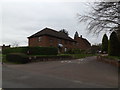
The property market in NR10 3GX is distinctly owner-occupied, with 72 per cent of all homes held by their owners. This high ownership rate signals a community where residents have made long-term investments in the area. Houses form the dominant accommodation type, meaning you will find traditional detached or semi-detached properties rather than flats or high-rise blocks. This housing stock appeals to families, retirees, and professionals seeking a permanent base rather than temporary accommodation. Given the small size of the postcode area, covering just 9481 square metres, inventory levels remain limited. Buyers looking at homes in NR10 3GX should expect a competitive market where available stock sells quickly. The prevalence of houses over apartments suggests that the local landscape favours spacious living environments with private gardens and separate grounds. This makes the area particularly suitable for those who require space for children or elderly relatives. The high ownership percentage also implies that many sellers in NR10 3GX are motivated by liquidity needs or downsizing rather than moving between rentals. When viewing properties, you will encounter a mix of periods, but the consistent housing type ensures a uniform architectural character throughout the cluster. This market structure rewards patience, as the right home in this specific postcode may require targeted negotiation given the constrained supply of listed houses.
House Prices in NR10 3GX
Showing 18 properties
| Address | Type | Beds | Baths | Last Sale Price | Last Sale Date | |
|---|---|---|---|---|---|---|
| 8 Post Mill Close, Newton St Faith, NR10 3GX | house | - | - | £89,000 | Dec 2021 | |
| 1 Post Mill Close, Newton St Faith, NR10 3GX | house | - | - | £270,000 | Jul 2021 | |
| 3 Post Mill Close, Newton St Faith, NR10 3GX | house | - | - | £265,000 | Jun 2021 | |
| 20 Post Mill Close, Newton St Faith, NR10 3GX | Semi-detached | - | - | - | - | |
| 13 Post Mill Close, Newton St Faith, NR10 3GX | house | - | - | - | - | |
| 9 Post Mill Close, Newton St Faith, NR10 3GX | Bungalow | - | - | - | - | |
| 15 Post Mill Close, Newton St Faith, NR10 3GX | house | - | - | - | - | |
| 19 Post Mill Close, Newton St Faith, NR10 3GX | house | - | - | - | - | |
| 21 Post Mill Close, Newton St Faith, NR10 3GX | house | - | - | - | - | |
| 4 Post Mill Close, Newton St Faith, NR10 3GX | house | - | - | - | - |
Energy Efficiency in NR10 3GX
Daily life in NR10 3GX benefits from proximity to several key amenities within practical reach. Retail options include the East of England Co-operative Co and Morrisons Old, providing residents with convenient access to groceries and everyday essentials. These shops are situated close enough to incorporate into regular weekly errands without requiring significant time or fuel expenditure. For travel needs, Norwich International Airport lies nearby, facilitating quick flights for business or leisure. Rail access is equally strong, with three railway stations within reach: Salhouse Railway Station, Hoveton & Wroxham Railway Station, and Norwich Railway Station. Public transport is further enhanced by metro services to Wroxham and Aylsham, offering scenic and direct connections to popular Norfolk destinations. Living in NR10 3GX means you do not need to rely solely on a car for all journeys. The presence of these transport hubs integrates the residential cluster into the wider regional network efficiently. You can easily reach Norwich city centre or commute to other towns via train. Shops and transport nodes operate in close coordination, creating a convenient lifestyle where practical needs are met swiftly. This proximity to retail and travel infrastructure ensures that NR10 3GX functions as a well-connected pocket of the greater Norwich region, combining residential calm with easy access to the amenities of larger towns.
Amenities
Schools
Families living in NR10 3GX have access to a specific selection of educational institutions nearby. The primary education option is St Faiths CofE Primary School, which holds an Ofsted rating of 'good'. This single primary school serves as the immediate educational anchor for children residing within the cluster. The fact that this school carries a 'good' rating indicates a standard of teaching and provision that meets the majority of national expectations for primary education. For secondary education, the data provided does not list specific schools directly within NR10 3GX. However, the current primary provision offers a solid foundation for young children growing up in the area. Parents reliant on a 'good' rated primary school can send their children to St Faiths CofE Primary School with confidence in the quality of their early education. The concentration of school resources in the immediate vicinity of NR10 3GX means that short bus journeys or walking routes to school are feasible for local families. You do not need to look far for primary schooling options, which simplifies the relocation process for families relocating to this postcode. The presence of this specific facility ensures that elementary education is locally manageable, reducing the need for long-distance travel during the school week.
| Rank | School | Type | Entry gender | Ages |
|---|
Explore more schools in this area
Go to Schools tabDemographics
The community in NR10 3GX reflects a settled demographic profile with a median age of 47 years. Most residents fall within the adult range of 30 to 64 years, indicating a population that has established roots in the location rather than being dominated by students or young professionals transiting through the town. This age distribution suggests a neighbourhood where families have grown up or retired locally, contributing to a stable social fabric. Home ownership stands at 72 per cent, meaning the majority of households own their properties outright or with a mortgage rather than renting. Accommodation in NR10 3GX consists primarily of houses, which aligns with the older, family-oriented age profile of the residents. This housing stock supports smaller family units or retirees seeking single-family dwellings rather than high-density apartments. The predominant ethnic group is White, consistent with the broader regional composition of Norfolk and surrounding areas. With 72 per cent of homes owned, the area likely boasts long-term residents who have invested in local improvements. You will find a demographic that values stability and continuity. The low turnover associated with high ownership rates means neighbours often know each other over several decades, creating a reliable support network for anyone considering moving into this established cluster.
Household Size
Accommodation Type
Tenure
Ethnic Group
Religion
Household Composition
Age
Household Deprivation
NS-SEC
Explore more demographic insights in this area
Go to Demographics tabPlanning
Planning Constraints
- Flood RiskPremium
- Ramsar Wetland SitesPremium
- Area of Outstanding Natural BeautyPremium
- Protected Nature ReservePremium
- Protected WoodlandPremium