Area Overview for MK43 7QT
Photos of MK43 7QT
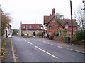
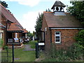

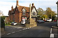
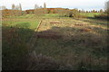
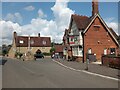


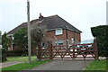

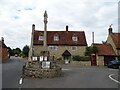

33 photos from this area
Area Information
Key information about the MK43 7QT including its size, population, and administrative classification.
- Area Type
- Postcode
- Area Size
- 23.0 hectares
- Population
- 1508
- Population Density
- 97 people/km²
House Prices in MK43 7QT
38
Properties
£392,773
Average Sold Price
£96,000
Lowest Price
£1,250,000
Highest Price
Showing 38 properties
| Address | Type | Beds | Baths | Last Sale Price | Last Sale Date | |
|---|---|---|---|---|---|---|
| 44 Court Lane, Stevington, MK43 7QT | Semi-detached | 4 | 2 | £510,000 | Sep 2025 | |
| The Old Barn, 25C Court Lane, Stevington, MK43 7QT | Detached | 2 | 2 | £495,000 | Jul 2025 | |
| Primrose Cottage, 25 Court Lane, Stevington, MK43 7QT | house | - | - | £495,000 | Jul 2025 | |
| 37 Court Lane, Stevington, MK43 7QT | Terraced | 3 | 1 | £180,000 | Jan 2025 | |
| Ashford House, 30A Court Lane, Stevington, MK43 7QT | house | - | - | £1,250,000 | Aug 2024 | |
| 52 Court Lane, Stevington, MK43 7QT | house | - | - | £345,000 | Jan 2024 | |
| 42 Court Lane, Stevington, MK43 7QT | house | - | - | £300,000 | Nov 2020 | |
| 23 Court Lane, Stevington, MK43 7QT | house | 3 | 2 | £372,500 | Oct 2020 | |
| 46 Court Lane, Stevington, MK43 7QT | Terraced | 3 | 2 | £375,000 | Jul 2019 | |
| 54 Court Lane, Stevington, MK43 7QT | house | - | - | £302,000 | Feb 2019 |
Page 1 of 4
Energy Efficiency in MK43 7QT
Amenities
Schools
| Rank | School | Type | Entry gender | Ages |
|---|
Explore more schools in this area
Go to Schools tabDemographics
Household Size
Two person
most common
Accommodation Type
Houses
most common
Tenure
81
majority
Ethnic Group
White
most common
Religion
N/A
most common
Household Composition
N/A
most common
Age
47
median
Adults (30-64 years)
most common
Household Deprivation
N/A
with no deprivation
NS-SEC
45
in Lower managerial occupations
Explore more demographic insights in this area
Go to Demographics tabPlanning
Planning Constraints
- Flood RiskPremium
- Ramsar Wetland SitesPremium
- Area of Outstanding Natural BeautyPremium
- Protected Nature ReservePremium
- Protected WoodlandPremium