Area Overview for LU6 1LR
Photos of LU6 1LR


Area Information
Living in LU6 1LR means inhabiting a compact, densely populated postcode area of 392 m², home to 1,835 residents. This small residential cluster is characterised by its high population density of 4,682,788 people per km², reflecting a tightly knit community. Daily life here is shaped by proximity to essential services, with 5 retail outlets nearby, including Iceland Dunstable and Asda Dunstable, and 4 rail stations within reach, such as Leagrave and Luton. The area’s compact nature makes it practical for those prioritising convenience over space. With a median age of 47 and a population skewed towards adults aged 30–64, LU6 1LR is a mature community where homeownership rates stand at 56%, suggesting a stable, long-term resident base. The presence of a primary school with a good Ofsted rating further underscores its appeal for families. While the area lacks natural constraints like protected woodlands or AONBs, its safety profile is strong, with low crime risk and no flood exposure. For buyers, LU6 1LR offers a blend of practicality and accessibility, though its small size means housing choices are limited to the immediate vicinity.
- Area Type
- Postcode
- Area Size
- 392 m²
- Population
- 1835
- Population Density
- 8207 people/km²
The property market in LU6 1LR is defined by a 56% homeownership rate, indicating a majority of properties are owner-occupied rather than rented. This suggests a stable market with a focus on long-term investment, as opposed to a transient rental-driven economy. The accommodation type is predominantly houses, which is unusual for a small postcode area but may reflect a mix of semi-detached or terraced properties. Given the area’s compact size, the housing stock is likely limited to the immediate vicinity, meaning buyers may need to consider nearby areas for more options. The high population density and small area size suggest that properties here are likely to be smaller in scale, prioritising practicality over expansive living spaces. For buyers, this means a market where demand for family homes is strong, but availability is constrained by the postcode’s physical boundaries. The absence of planning constraints or environmental restrictions further supports the feasibility of property development, though the small size of LU6 1LR may limit future expansion.
House Prices in LU6 1LR
Showing 1 properties
| Address | Type | Beds | Baths | Last Sale Price | Last Sale Date | |
|---|---|---|---|---|---|---|
| Beacon House, 5 Regent Street, Dunstable, LU6 1LR | Office | - | - | - | - |
Energy Efficiency in LU6 1LR
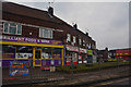
Residents of LU6 1LR have access to a range of retail amenities within practical reach, including Iceland Dunstable, Asda Dunstable, and Aldi Beecroft. These stores provide essential shopping options for groceries and household goods, supporting a practical, self-sufficient lifestyle. The presence of multiple retail outlets suggests a focus on convenience, though the area lacks specific data on dining or leisure venues. The rail stations nearby, such as Harlington and Luton, offer connections to broader networks, enabling access to cultural, recreational, and professional opportunities beyond the immediate postcode. While the data does not mention parks or green spaces, the absence of protected natural areas or AONB designations implies that the area’s character is shaped more by its compact residential layout than by natural landscapes. The combination of retail accessibility and rail connectivity makes LU6 1LR a practical choice for those valuing ease of access to services and efficient travel.
Amenities
Schools
The nearest school to LU6 1LR is Ashton St Peter’s VA C of E School, a primary school with a good Ofsted rating. This provides a reliable option for families with young children, though no secondary schools are listed in the data. The presence of a single primary school suggests that parents may need to look beyond the immediate area for secondary education, which could influence decisions about where to live. The school’s good rating indicates a standard of education that meets regulatory benchmarks, though specific details about curriculum or performance are not provided. For families prioritising proximity to educational institutions, LU6 1LR offers a foundation with its primary school, but additional research would be needed to assess secondary school options. The school’s location within practical reach of residents reinforces the area’s appeal for families seeking a balanced mix of community and educational infrastructure.
| Rank | School | Type | Entry gender | Ages |
|---|
Explore more schools in this area
Go to Schools tabDemographics
LU6 1LR’s population of 1,835 is predominantly composed of adults aged 30–64, with a median age of 47. This suggests a community of established professionals and families, rather than a younger or elderly demographic. Home ownership is robust at 56%, indicating a stable housing market with a focus on long-term residency. The area is largely composed of houses, reflecting a preference for single-family dwellings over flats or apartments. The predominant ethnic group is White, though no specific data on diversity or deprivation is provided. The high population density of 4,682,788 people per km² implies a compact, efficient use of space, which may influence the character of daily life. With no mention of socioeconomic deprivation, the area appears to support a quality of life aligned with its safety and infrastructure. The demographic profile suggests a community where familiarity and continuity are key, with limited turnover of residents.
Household Size
Accommodation Type
Tenure
Ethnic Group
Religion
Household Composition
Age
Household Deprivation
NS-SEC
Explore more demographic insights in this area
Go to Demographics tabPlanning
Planning Constraints
- Flood RiskPremium
- Ramsar Wetland SitesPremium
- Area of Outstanding Natural BeautyPremium
- Protected Nature ReservePremium
- Protected WoodlandPremium