Area Overview for IG10 3HL
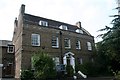
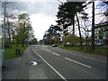
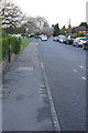
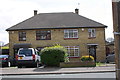
Photos of IG10 3HL


Area Information
Living in IG10 3HL means inhabiting a compact, residential postcode area in England, where 1,505 people reside across 7,440 square metres. This small cluster is densely populated, with 202,296 people per square kilometre, reflecting a tightly knit community. The area’s character is defined by its proximity to transport hubs and local amenities, making it practical for daily life. While it lacks expansive green spaces, its accessibility to nearby stations and shops balances this. The demographic profile suggests a mature population, with adults aged 30–64 forming the majority. Homeownership is high at 68%, indicating stability, and the accommodation is predominantly houses, which may appeal to those seeking traditional living. IG10 3HL is not a sprawling suburb but a focused, manageable area where convenience and connectivity outweigh space. For buyers, it offers a snapshot of suburban England, where proximity to infrastructure and a low crime rate combine to create a functional, if compact, living environment.
- Area Type
- Postcode
- Area Size
- 7440 m²
- Population
- 1505
- Population Density
- 5375 people/km²
The property market in IG10 3HL is characterised by a high rate of home ownership—68%—suggesting a community of long-term residents rather than a transient rental market. The accommodation is predominantly houses, which may appeal to those seeking traditional, family-friendly homes. Given the area’s small size and high population density, the housing stock is likely limited, with properties concentrated in a compact cluster. This makes the market competitive for buyers, particularly those seeking to move into the area. The focus on owner-occupation implies stable property values, though the small size of the postcode means the market is not large enough to support significant diversity in housing types. For buyers, this suggests a need to act quickly, as the availability of homes may be constrained by the area’s physical and demographic boundaries.
House Prices in IG10 3HL
Showing 16 properties
| Address | Type | Beds | Baths | Last Sale Price | Last Sale Date | |
|---|---|---|---|---|---|---|
| 8 Alderton Rise, Loughton, IG10 3HL | Semi-detached | 3 | 2 | £675,000 | Jul 2024 | |
| 9 Alderton Rise, Loughton, IG10 3HL | Semi-detached | 3 | 1 | £589,000 | Jul 2023 | |
| 7 Alderton Rise, Loughton, IG10 3HL | house | - | - | £600,000 | Dec 2022 | |
| 12 Alderton Rise, Loughton, IG10 3HL | house | - | - | £655,000 | Apr 2021 | |
| 10 Alderton Rise, Loughton, IG10 3HL | house | 3 | 1 | £570,000 | Nov 2019 | |
| 1 Alderton Rise, Loughton, IG10 3HL | Detached | 3 | 1 | £622,500 | Sep 2019 | |
| 4 Alderton Rise, Loughton, IG10 3HL | house | - | - | £480,000 | Jun 2015 | |
| 3 Alderton Rise, Loughton, IG10 3HL | Detached | 3 | - | £545,000 | May 2014 | |
| 2 Alderton Rise, Loughton, IG10 3HL | Detached | 3 | 1 | £465,000 | Jan 2013 | |
| 14 Alderton Rise, Loughton, IG10 3HL | house | - | - | £500,000 | Oct 2007 |
Energy Efficiency in IG10 3HL
The lifestyle in IG10 3HL is shaped by its proximity to retail, transport, and leisure hubs. Within practical reach are five retail outlets, including Cook Loughton, Sainsburys Loughton, and Morrisons Loughton, offering everyday shopping needs. The area’s transport network includes five metro stations, five rail stations, and a bus interchange, facilitating easy access to work, schools, and amenities. While no specific parks or leisure facilities are listed in the data, the density of retail and transport options suggests a focus on convenience over expansive recreational spaces. This makes IG10 3HL suitable for those prioritising accessibility over sprawling green areas. The mix of shops and transport links creates a functional, if compact, lifestyle, ideal for commuters and families reliant on public infrastructure.
Amenities
Schools
Near IG10 3HL are three primary schools, including The Alderton Junior School, The Alderton Infant School, and The Alderton Infant School and Nursery, which is an academy rated ‘good’ by Ofsted. This mix of school types provides options for families, from traditional state schools to academies with potentially distinct curricula. The presence of multiple primary schools within practical reach suggests a focus on education accessibility, which is crucial for parents. The ‘good’ rating at the nursery and infant school indicates a baseline standard of teaching and facilities, though no secondary schools are listed in the data. For families prioritising education, this cluster of schools offers convenience, though further research would be needed to assess secondary options in the wider area.
| Rank | School | Type | Entry gender | Ages |
|---|
Explore more schools in this area
Go to Schools tabDemographics
The community in IG10 3HL is predominantly composed of adults aged 30–64, with a median age of 47. This suggests a mature population, likely with established careers and families. Homeownership is strong, at 68%, which aligns with the area’s focus on houses as the primary accommodation type. The predominant ethnic group is White, reflecting a homogenous demographic profile. While no specific data on deprivation is provided, the high home ownership and low crime rate imply a relatively stable socioeconomic environment. The absence of detailed diversity metrics means the community’s cultural makeup remains less defined in the data. For residents, this translates to a predictable, low-risk environment where property values and community dynamics are likely to remain consistent. The age profile also hints at a population that may prioritise practicality over novelty, with a focus on long-term residence.
Household Size
Accommodation Type
Tenure
Ethnic Group
Religion
Household Composition
Age
Household Deprivation
NS-SEC
Explore more demographic insights in this area
Go to Demographics tabPlanning
Planning Constraints
- Flood RiskPremium
- Ramsar Wetland SitesPremium
- Area of Outstanding Natural BeautyPremium
- Protected Nature ReservePremium
- Protected WoodlandPremium