Area Overview for Northchurch
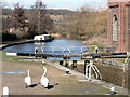
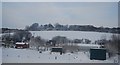
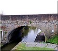
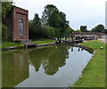
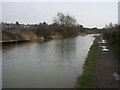
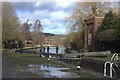
Photos of Northchurch

Area Information
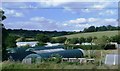
Northchurch is a civil parish in England covering an area of 15.0 km². It stands as a defined local community with established boundaries and a distinct character. The landscape is partly shaped by its protected natural features, as the area sits within the designations of an Area of Outstanding Natural Beauty. This status brings planning constraints that limit development but preserve the rural frame. You will find more trees and woodlands here than in many neighbouring districts, with protected woodland making up a small but significant portion of the land. A protected nature reserve also contributes to the environmental quality of the location. These designations mean that the rural setting remains intact for those choosing to live in Northchurch. The land size allows for a spread-out living environment rather than a dense urban cluster. Daily life here is influenced by this commitment to open space and conservation. The parish offers a setting where nature plays a central role in the resident experience. Any property choice in this area must align with these environmental boundaries. You are buying into a location where growth is managed strictly to protect the landscape. This structure defines the quiet rhythm of life for everyone living in Northchurch. The community in Northchurch presents a clear age profile with a median age of 70. This figure indicates that the population is heavily skewed towards older residents compared to national averages. The most common age group spans the total age range, suggesting a diverse spread across all decades but a strong concentration later in life. This demographic shape typically reflects a settlement favoured by retirees or those with empty-nest families. Home ownership levels in Northchurch remain exceptionally high at 89 per cent. Such a rate signals that the vast majority of households have already purchased their dwellings. This statistic points to a property market where sales have largely concluded for the immediate future. Household composition and accommodation type data confirm this stability without offering granular breakdowns of family structures. Ethnic diversity and religious affiliation are noted only as total categories in the available records. The lack of specific breakdowns suggests the community may lack recent demographic shifts or extensive recorded diversity in official datasets. For homebuyers, the high ownership rate implies that renting opportunities are scarce. Quality of life here is likely defined by the stability of long-term residents. You are entering a neighbourhood where the neighbour list is unlikely to change quickly. The older population demographic means services and amenities may be tailored to mature needs rather than young families. Every resident shares a connection to this established, older community fabric. The property market in Northchurch is defined by a dominant culture of ownership rather than renting. With home ownership standing at 89 per cent, you will find that the majority of properties are held by their owners. This high figure indicates a static market where transfer of title is less frequent than in urban centres with high rental yields. Accommodation types do not have a specific breakdown provided, yet the ownership rate strongly suggests traditional stock rather than social housing or student lets. Homes in Northchurch are therefore likely to be owner-occupied properties passing from one generation to another or sold between private parties. This market structure means that buying a house here often involves dealing with an existing owner rather than a landlord. The 89 per cent ownership rate creates a baseline of stability where tenants are a minority. Consequently, lease extensions or buy-to-let investments are less common drivers of the local economy. You should expect to pay the asking price without a competitive bidding war from investors seeking yield. The housing stock reflects the median age of 70, implying a need for larger homes or properties with space foraging families into retirement. Living in Northchurch means purchasing a home that is kept by the person who lives there most days. Market activity will be slower, driven by necessity rather than speculation. Digital connectivity in Northchurch supports standard modern living needs through robust network coverage. Your broadband experience is characterised by a fixed broadband quality score of 74. This rate qualifies as good for an area of its size and eliminates concerns about basic streaming or web browsing. You can expect file downloads and video calls to run smoothly for daily use. Mobile network quality presents an even stronger profile with a score of 82. This rating is excellent for voice calls and incoming communications for anyone living in Northchurch. Signal quality at this level should support navigation apps and on-the-go connectivity for drivers using local roads. These connectivity levels make the parish suitable for working from home without significant lag. You do not need to sacrifice internet speed for the quiet countryside lifestyle. Both the fixed line and mobile networks provide reliable foundations for remote work or education. The scores indicate that the digital infrastructure is upgraded beyond the minimum threshold. Daily internet use, whether for banking, entertainment, or administration, will function efficiently. You will not face the frustration of frequent dropouts or slow loading times. The digital landscape here is sufficient for a household reliant on modern technology. Safety and environmental factors in Northchurch present a balanced picture of risk and preservation. Crime risk is low with a score of 83, placing the area well below the national average. This assessment confirms that Northchurch is a safer neighbourhood than many peers. Residents can move around with greater confidence regarding personal security. Flood risk is similarly minimal, recorded at just 0.47. This very low figure means the settlement is not significantly exposed to waterlogging or river interference. Planning constraints do introduce specific environmental considerations that shape the land. The area sits within an Area of Outstanding Natural Beauty, marking it with a warning status due to conservation limits. This designation restricts building heights and developments to protect the visual setting. Furthermore, the parish contains protected nature reserves and protected woodland, both flagged with warning levels in planning assessments. These scores reflect the presence of ecological assets rather than a threat to daily safety. Ramsar wetland sites show no coverage with a score of 0. For a homebuyer, these factors mean you will value homes in Northchurch for their proximity to protected natural spaces. The trade-off is that expanding home boundaries or altering the garden may face stricter scrutiny. The security profile remains strong while the environment stays carefully guarded by statutory protection. Is Northchurch suitable for families or retirees given the demographic balance?Northchurch has a median age of 70, indicating a community dominated by older adults. While the exact age range breakdown is not fully detailed, this profile suggests the area appeals primarily to retirees or those losing children. The high home ownership rate of 89 per cent reinforces the lack of a large rental sector for young tenants. You should consider whether the local pace and services match your needs if you are a young family. The area offers stability and a quiet setting rather than the amenities often sought by schools and toddlers. How reliable is the internet connection for remote workers?Digital infrastructure in Northchurch is strong enough for working from home. Your fixed broadband scores 74 out of 100, which classifies as good performance for streaming and calls. Mobile coverage is even better, scoring 82, meaning you have excellent signal for communications. These ratings indicate that you can rely on high-speed internet without significant interruptions while living in the parish. What are the main safety concerns for residents of Northchurch?Safety concerns are minimal in this parish. Crime risk is low with a score of 83, showing below-average crime rates compared to the rest of England. Flood risk is negligible at 0.47. The primary planning constraints involve environmental protection rather than safety hazards. You will find the area is secure from both criminal activity and natural disasters like flooding. Are there restrictions on property development in this area?Yes, Northchurch faces specific planning constraints due to its location within an Area of Outstanding Natural Beauty. The area also contains protected nature reserves and protected woodland. These designations introduce warning-level restrictions that limit new builds and alterations. While these rules preserve the landscape, they mean that buying a home here may involve stricter controls on future extensions compared to less protected zones.
- Area Type
- Parish
- Area Size
- 15.0 km²
- Population
- Not available
- Population Density
- Not available
Demographics
The community in Northchurch presents a clear age profile with a median age of 70. This figure indicates that the population is heavily skewed towards older residents compared to national averages. The most common age group spans the total age range, suggesting a diverse spread across all decades but a strong concentration later in life. This demographic shape typically reflects a settlement favoured by retirees or those with empty-nest families. Home ownership levels in Northchurch remain exceptionally high at 89 per cent. Such a rate signals that the vast majority of households have already purchased their dwellings. This statistic points to a property market where sales have largely concluded for the immediate future. Household composition and accommodation type data confirm this stability without offering granular breakdowns of family structures. Ethnic diversity and religious affiliation are noted only as total categories in the available records. The lack of specific breakdowns suggests the community may lack recent demographic shifts or extensive recorded diversity in official datasets. For homebuyers, the high ownership rate implies that renting opportunities are scarce. Quality of life here is likely defined by the stability of long-term residents. You are entering a neighbourhood where the neighbour list is unlikely to change quickly. The older population demographic means services and amenities may be tailored to mature needs rather than young families. Every resident shares a connection to this established, older community fabric. The property market in Northchurch is defined by a dominant culture of ownership rather than renting. With home ownership standing at 89 per cent, you will find that the majority of properties are held by their owners. This high figure indicates a static market where transfer of title is less frequent than in urban centres with high rental yields. Accommodation types do not have a specific breakdown provided, yet the ownership rate strongly suggests traditional stock rather than social housing or student lets. Homes in Northchurch are therefore likely to be owner-occupied properties passing from one generation to another or sold between private parties. This market structure means that buying a house here often involves dealing with an existing owner rather than a landlord. The 89 per cent ownership rate creates a baseline of stability where tenants are a minority. Consequently, lease extensions or buy-to-let investments are less common drivers of the local economy. You should expect to pay the asking price without a competitive bidding war from investors seeking yield. The housing stock reflects the median age of 70, implying a need for larger homes or properties with space foraging families into retirement. Living in Northchurch means purchasing a home that is kept by the person who lives there most days. Market activity will be slower, driven by necessity rather than speculation. Digital connectivity in Northchurch supports standard modern living needs through robust network coverage. Your broadband experience is characterised by a fixed broadband quality score of 74. This rate qualifies as good for an area of its size and eliminates concerns about basic streaming or web browsing. You can expect file downloads and video calls to run smoothly for daily use. Mobile network quality presents an even stronger profile with a score of 82. This rating is excellent for voice calls and incoming communications for anyone living in Northchurch. Signal quality at this level should support navigation apps and on-the-go connectivity for drivers using local roads. These connectivity levels make the parish suitable for working from home without significant lag. You do not need to sacrifice internet speed for the quiet countryside lifestyle. Both the fixed line and mobile networks provide reliable foundations for remote work or education. The scores indicate that the digital infrastructure is upgraded beyond the minimum threshold. Daily internet use, whether for banking, entertainment, or administration, will function efficiently. You will not face the frustration of frequent dropouts or slow loading times. The digital landscape here is sufficient for a household reliant on modern technology. Safety and environmental factors in Northchurch present a balanced picture of risk and preservation. Crime risk is low with a score of 83, placing the area well below the national average. This assessment confirms that Northchurch is a safer neighbourhood than many peers. Residents can move around with greater confidence regarding personal security. Flood risk is similarly minimal, recorded at just 0.47. This very low figure means the settlement is not significantly exposed to waterlogging or river interference. Planning constraints do introduce specific environmental considerations that shape the land. The area sits within an Area of Outstanding Natural Beauty, marking it with a warning status due to conservation limits. This designation restricts building heights and developments to protect the visual setting. Furthermore, the parish contains protected nature reserves and protected woodland, both flagged with warning levels in planning assessments. These scores reflect the presence of ecological assets rather than a threat to daily safety. Ramsar wetland sites show no coverage with a score of 0. For a homebuyer, these factors mean you will value homes in Northchurch for their proximity to protected natural spaces. The trade-off is that expanding home boundaries or altering the garden may face stricter scrutiny. The security profile remains strong while the environment stays carefully guarded by statutory protection. Is Northchurch suitable for families or retirees given the demographic balance?Northchurch has a median age of 70, indicating a community dominated by older adults. While the exact age range breakdown is not fully detailed, this profile suggests the area appeals primarily to retirees or those losing children. The high home ownership rate of 89 per cent reinforces the lack of a large rental sector for young tenants. You should consider whether the local pace and services match your needs if you are a young family. The area offers stability and a quiet setting rather than the amenities often sought by schools and toddlers. How reliable is the internet connection for remote workers?Digital infrastructure in Northchurch is strong enough for working from home. Your fixed broadband scores 74 out of 100, which classifies as good performance for streaming and calls. Mobile coverage is even better, scoring 82, meaning you have excellent signal for communications. These ratings indicate that you can rely on high-speed internet without significant interruptions while living in the parish. What are the main safety concerns for residents of Northchurch?Safety concerns are minimal in this parish. Crime risk is low with a score of 83, showing below-average crime rates compared to the rest of England. Flood risk is negligible at 0.47. The primary planning constraints involve environmental protection rather than safety hazards. You will find the area is secure from both criminal activity and natural disasters like flooding. Are there restrictions on property development in this area?Yes, Northchurch faces specific planning constraints due to its location within an Area of Outstanding Natural Beauty. The area also contains protected nature reserves and protected woodland. These designations introduce warning-level restrictions that limit new builds and alterations. While these rules preserve the landscape, they mean that buying a home here may involve stricter controls on future extensions compared to less protected zones.
Household Size
Accommodation Type
Tenure
Ethnic Group
Religion
Household Composition
Age
Household Deprivation
NS-SEC
Explore more demographic insights in this area
Go to Demographics tabPlanning
Planning Constraints
- Flood RiskPremium
- Ramsar Wetland SitesPremium
- Area of Outstanding Natural BeautyPremium
- Protected Nature ReservePremium
- Protected WoodlandPremium