Area Overview for Great Totham
Photos of Great Totham


Area Information
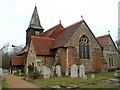
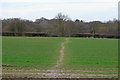
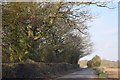
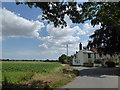
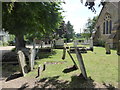
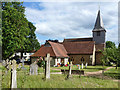
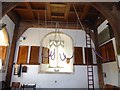
Great Totham is a civil parish situated in the Maldon district of Essex. You will find it positioned midway between Chelmsford and Colchester, forming part of the Hundred of Thurstable. The area covers 14.5 km² and includes the smaller settlement of the Island. Historical depth characterises this village; the earliest documentary reference dates to the mid-10th century. St Peter's Church existed by 1181, while the Honywood family owned much of the land from the 18th century. Today, you can see the legacy of this history in landmarks such as Honywood School, built in 1857. The parish features three churches, including St Peter's Church of England, a United Reformed Church built in 1871, and the free-denomination Barn Church. Living in Great Totham offers a connection to a long-established community. The postcode CM8 3LX marks a location distinct from larger urban centres. You are surrounded by a neighbourhood where the past is visible in the buildings and land use. The presence of protected woodland within the parish boundaries adds a layer of environmental significance to daily life. This area is not just a collection of homes but a historic site with active religious and community institutions. The village structure remains intact, allowing residents to experience rural living while maintaining proximity to the towns of Maldon, Chelmsford, and Colchester.
- Area Type
- Parish
- Area Size
- 14.5 km²
- Population
- Not available
- Population Density
- Not available
Demographics
The community in Great Totham reflects a settled population structure. The median age here is 70 years old, indicating an older resident base. This age profile suggests that the area is dominated by retirees or long-term residents rather than young families or commuters. Home ownership stands at a remarkable 85% of the total households. This high rate points to a stable community where people stay and put their roots down. The village is not a commuter belt property exchange where tenants change every few years. You will find that the population is relatively uniform in its composition. The data shows total figures for household and accommodation types, meaning specific breakdowns for student housing or temporary stays are not applicable here. The demographic fabric is consistent because the age structure is naturally dominant in the 70-plus bracket. This means daily life revolves around the needs of an older demographic. Services and local arrangements likely cater to this age group. You should be aware that the community feel is built on longevity. There are no indications of rapid population influx or significant demographic shifts. The 85% ownership rate ensures that the residents have a vested interest in the long-term stability of Great Totham.
Household Size
Accommodation Type
Tenure
Ethnic Group
Religion
Household Composition
Age
Household Deprivation
NS-SEC
Explore more demographic insights in this area
Go to Demographics tabPlanning
Planning Constraints
- Flood RiskPremium
- Ramsar Wetland SitesPremium
- Area of Outstanding Natural BeautyPremium
- Protected Nature ReservePremium
- Protected WoodlandPremium
- Crime RiskPremium