Area Overview for Broomfield
Photos of Broomfield


Area Information
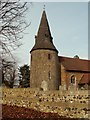
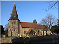
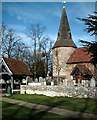
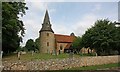
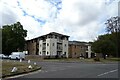
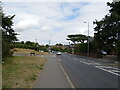
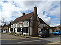
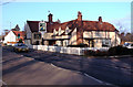
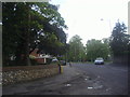
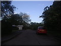
Broomfield is a civil parish and suburban village located within the Chelmsford district of Essex. This area sits approximately two to two and a half miles north of Chelmsford on the northern edge of the city's built-up zone. The parish covers a total area of 6.9 square kilometres, consisting mostly of cultivated farmland interspersed with footpaths. The main concentration of housing lies along the B1008 Main Road, where the settlement spans roughly 55 hectares. A 2021 population count recorded 6,756 residents, creating a tight-knit community that retains a distinct village character. You will find conservation areas such as Church Green, Angel Green, and Parsonage Green integrated into the landscape of rising terrain between 50 and 60 metres in elevation. Historically significant, the settlement dates back to 1086 when it was first recorded as Brumfelda in the Domesday Book. Evidence of pre-Roman occupation and Roman presence exists within the local geology, while the Church of St Mary with St Leonard dates to the late 11th century. Despite stripping by an F1 or T2 tornado on 23 November 1981, the village remains central to local life, anchored by amenities like Broomfield Hall and historic farmhouses. Daily life in Broomfield balances rural tranquility with proximity to urban services. The River Chelmer weir and five village greens, including Parsonage with its tithe barn and pond, provide recreational spaces. Local sports clubs, such as the football team established in 1905 and a cricket club, offer traditional community engagement. Living in Broomfield means accessing the main route on the B1008 while enjoying the quiet of the surrounding farmland and historic architecture. The location near the Eastern Counties railway historically links the parish to wider regional networks, facilitating journeys to larger urban centres like London Liverpool Street via Chelmsford station.
- Area Type
- Parish
- Area Size
- 6.9 km²
- Population
- Not available
- Population Density
- Not available
Demographics
The community profile within Broomfield reveals a settled population with a median age of 70 years. This demographic data indicates that the town is populated predominantly by older residents, likely drawn to the suburban setting and lower living costs. The most common age category is listed simply as Age Total, suggesting a broad distribution without a specific youthful skew typical of university towns. You should expect neighbours who have lived in the area for decades, contributing to a stable social fabric where families and retirees coexist. Home ownership stands at a solid 72%, reflecting an area where permanent residents rather than transient tenants dominate the housing market. This high percentage of owner-occupiers often correlates with lower household turnover and stronger local engagement in village institutions. The household composition and accommodation type data cover the total population, confirming that the existing housing stock supports diverse living arrangements suitable for this age profile. There is no indication of unaccompanied overcrowding or shared schemes, implying a standard mix of single-family homes and perhaps some smaller units adapted for the demographic. Ethnic diversity and religious affiliation data are recorded as totals, indicating an existing multicultural population without the need for further qualification in the narrative. While specific breakdowns are not detailed here, the general census data supports a community integrated along these lines. Deprivation metrics are not explicitly isolated in the provided figures, but the high ownership rates suggest economic stability among the majority of residents. For those considering homes in Broomfield, the demographic reality points to a quiet, established environment where life moves at a slower pace suited to retirement or established families. The population size of 6,756 reinforces the sense that this is a local community rather than a sprawling conurbation.
Household Size
Accommodation Type
Tenure
Ethnic Group
Religion
Household Composition
Age
Household Deprivation
NS-SEC
Explore more demographic insights in this area
Go to Demographics tabPlanning
Planning Constraints
- Flood RiskPremium
- Ramsar Wetland SitesPremium
- Area of Outstanding Natural BeautyPremium
- Protected Nature ReservePremium
- Protected WoodlandPremium