Area Overview for CO16 8ES
Photos of CO16 8ES
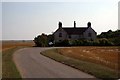
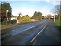
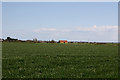
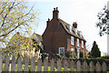
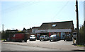
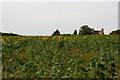
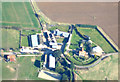
7 photos from this area
Area Information
Key information about the CO16 8ES including its size, population, and administrative classification.
- Area Type
- Postcode
- Area Size
- 1.4 km²
- Population
- 1704
- Population Density
- 162 people/km²
House Prices in CO16 8ES
21
Properties
£374,540
Average Sold Price
£303,000
Lowest Price
£470,000
Highest Price
Showing 21 properties
| Address | Type | Beds | Baths | Last Sale Price | Last Sale Date | |
|---|---|---|---|---|---|---|
| White House, Lee Wick Lane, St Osyth, CO16 8ES | house | - | - | £470,000 | Dec 2020 | |
| Elm View, Lee Wick Lane, St Osyth, CO16 8ES | Detached | 3 | 1 | £320,000 | Aug 2017 | |
| Sea Glimpse, Lee Wick Lane, St Osyth, CO16 8ES | Bungalow | 2 | 1 | £303,000 | Jul 2015 | |
| Kingsway Cottage, Lee Wick Lane, St Osyth, CO16 8ES | Detached | 3 | 1 | £405,000 | Aug 2014 | |
| Wild Acre Barn, Lee Wick Lane, St Osyth, CO16 8ES | house | - | - | £374,700 | Jan 2006 | |
| 2, Leewick Cottages, Lee Wick Lane, St Osyth, CO16 8ES | Semi-detached | 3 | 1 | - | - | |
| Outer Reach, Lee Wick Lane, St Osyth, CO16 8ES | Detached | 4 | 3 | - | - | |
| The Barn, Lee Wick Lane, St Osyth, CO16 8ES | Detached | 4 | 3 | - | - | |
| 3, Leewick Cottages, Lee Wick Lane, St Osyth, CO16 8ES | Semi-detached | 4 | 2 | - | - | |
| Lee Wick Lodge, Lee Wick Lane, St Osyth, CO16 8ES | Detached | 4 | - | - | - |
Page 1 of 3
Energy Efficiency in CO16 8ES
Amenities
Schools
| Rank | School | Type | Entry gender | Ages |
|---|
Explore more schools in this area
Go to Schools tabDemographics
Household Size
One person
most common
Accommodation Type
Houses
most common
Tenure
59
majority
Ethnic Group
White
most common
Religion
N/A
most common
Household Composition
N/A
most common
Age
47
median
Adults (30-64 years)
most common
Household Deprivation
N/A
with no deprivation
NS-SEC
20
in Lower managerial occupations
Explore more demographic insights in this area
Go to Demographics tabPlanning
Planning Constraints
- Flood RiskPremium
- Ramsar Wetland SitesPremium
- Area of Outstanding Natural BeautyPremium
- Protected Nature ReservePremium
- Protected WoodlandPremium