Area Overview for CO12 3LT
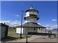
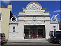
Photos of CO12 3LT


Area Information
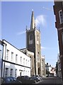
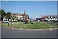
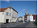
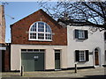
Living in CO12 3LT means residing within a specific postcode area that covers a small residential cluster of 4019 m². This location sits within Harwich, a port town and civil parish in the Tendring district of Essex. The town is positioned on the estuary of the River Stour on England's North Sea coast and serves as one of the Haven ports. Harwich functions as a major port town with an economy historically centred on maritime activities and commercial shipping. The civil parish of Harwich, which includes the neighbouring area of Dovercourt, had a population of 18,794 at the 2021 census. Your surroundings in this cluster are defined by a tight-knit residential environment where the built-up area reaches a population of 20,215. Daily life here is shaped by the town's deep historical roots. A chapel was recorded at the settlement in 1177, and the Duke of Norfolk obtained the right to hold a market in 1253. Households benefit from proximity to significant local landmarks, including St. Nicholas, the parish church constructed between 1820 and 1822, which features many original furnishings. The only Grade I listed building in Harwich is the Guildhall, dating from 1769 and housing the town council at 11 Church Street. Residents also have access to distinctive medieval maritime architecture, such as a sailmaker's house on Kings Head Street, thought to have been built circa 1600. This setting offers a blend of practical coastal living and preserved historical character within the broader Tendring district.
- Area Type
- Postcode
- Area Size
- 4019 m²
- Population
- 1456
- Population Density
- 2709 people/km²
The property market in CO12 3LT is characterised by a significant presence of owner-occupiers. Currently, 55% of homes are owner-occupied, while the remaining 45% likely consists of rentals. This majority ownership suggests that purchasing property here is a central goal for many households. The accommodation type is listed as Houses, meaning the street furniture consists of detached, semi-detached, or terraced houses rather than flats or apartments. Buyers looking at homes in this small area should expect a traditional residential stock rather than urban high-density living. The market here serves families and individuals who value the stability often associated with owning a house in a named postcode cluster. Given the high home ownership rate, you may find that properties have been well-maintained by individuals who have lived in them for extended periods. The combination of Houses and strong ownership indicates a market where homeownership remains a tangible reality for the majority of households in this coastal Essex location.
House Prices in CO12 3LT
Showing 8 properties
| Address | Type | Beds | Baths | Last Sale Price | Last Sale Date | |
|---|---|---|---|---|---|---|
| 17 Main Road, Harwich, CO12 3LT | Terraced | 3 | 1 | £165,000 | May 2025 | |
| 15 Main Road, Harwich, CO12 3LT | house | - | - | - | - | |
| 23 Main Road, Harwich, CO12 3LT | Terraced | - | - | - | - | |
| 27 Main Road, Harwich, CO12 3LT | Terraced | - | - | - | - | |
| 29 Main Road, Harwich, CO12 3LT | house | - | - | - | - | |
| 21 Main Road, Harwich, CO12 3LT | house | - | - | - | - | |
| 19 Main Road, Harwich, CO12 3LT | house | - | - | - | - | |
| 25 Main Road, Harwich, CO12 3LT | Terraced | - | - | - | - |
Energy Efficiency in CO12 3LT
Residents of CO12 3LT enjoy convenient access to essential amenities within practical reach. For retail needs, the area is close to Iceland Dovercourt, East of England Co-operative Co, and Asda Harwich. These grocery stores and supermarkets are located nearby, ensuring that fresh food and daily necessities are easily available without long travel times. Transport links further enhance the lifestyle in this port town. There are five railway stations nearby, including Harwich Town Railway Station, Dovercourt Railway Station, and Harwich International Railway Station. Commuters can choose from these options to travel further afield depending on their destination. Additionally, five ferry locations are available, such as the Harwich Harbour Ferry Landing, Shotley Point Marina Ferry Landing, and Felixstowe for Harwich Ferry Landing. These connections provide international crossings or local sea travel. The proximity to these transport hubs makes CO12 3LT a practical location for professionals who require reliable rail or ferry access for their daily commutes.
Amenities
Schools
Families considering homes in CO12 3LT have access to Harwich Community Primary School and Nursery for their children. This institution is categorised as a primary school and holds a good Ofsted rating. The presence of a nursery element within the same building provides convenient early education options alongside standard primary schooling. This specific facility is the only school listed within the immediate vicinity of this postcode area. The reliance on Harwich Community Primary School and Nursery indicates that families living here are primarily accessing education within the local catchment areas of the town. While the area contains only one named school in the provided data, Harwich as a whole supports a wider education network. For residents with slightly older children, secondary education would likely be pursued at other institutions within the Tendring district. The good rating of the primary school reflects a quality standard for the foundational education received by pupils in the cluster.
| Rank | School | Type | Entry gender | Ages |
|---|
Explore more schools in this area
Go to Schools tabDemographics
The community in CO12 3LT reflects a mature and stable population structure. The median age is 47 years, and the most common age range is Adults (30-64 years). This suggests an area where families with older children may still reside alongside empty nesters and retirement-age dwellings. Home ownership stands at a high level of 55%, indicating that the area is predominantly owner-occupied rather than a rental market. This statistic shapes the nature of the neighbourhood, as residents are likely to have long-standing ties to their homes. Accommodation in this cluster consists primarily of Houses, catering to families and individuals seeking standalone or semi-detached living. The predominant ethnic group is White, shaping the cultural fabric of these 1456 residents. With a population density of 362294 people/km², the area boasts a very high concentration of residents within its limited footprint. This density creates an immediate sense of proximity between neighbours, integrating daily lives more closely than in sprawling suburban developments. The high percentage of homeowners suggests financial stability among the majority of residents who have invested in the local property market over time.
Household Size
Accommodation Type
Tenure
Ethnic Group
Religion
Household Composition
Age
Household Deprivation
NS-SEC
Explore more demographic insights in this area
Go to Demographics tabPlanning
Planning Constraints
- Flood RiskPremium
- Ramsar Wetland SitesPremium
- Area of Outstanding Natural BeautyPremium
- Protected Nature ReservePremium
- Protected WoodlandPremium