Area Overview for CO10 1WE
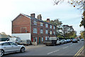
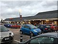
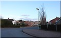
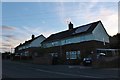
Photos of CO10 1WE
Area Information
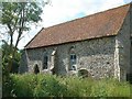
Living in CO10 1WE means residing within a small residential cluster covering exactly 1.8 hectares. This postcode represents a tightly knit neighbourhood influenced by its proximity to Sudbury, a market town in Suffolk with a population of 1,344 in the immediate vicinity. The area sits on the River Stour near the Essex border, positioned at coordinates approximately 52.046409, 0.732461. Residents here benefit from a history dating back to the 970s, when the first church was recorded, and the establishment of a market town in 1009. You are surrounded by landmarks such as the Church of All Saints, St Gregory's Church, and Thomas Gainsborough's birthplace museum. Daily life involves navigating streets where defensive features like historical ditches once diverted the river. With a population of 1,583 locally, this postcode offers a quiet existence away from major city centres while maintaining convenient links to the wider region. The location caters to those seeking a grounded lifestyle connected to Suffolk's heritage and the River Stour's legacy. You find a setting where the past informs the present, from the town's 12th-century religious sites to its modern digital infrastructure.
- Area Type
- Postcode
- Area Size
- 1.8 hectares
- Population
- 1583
- Population Density
- 6107 people/km²
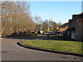
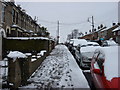
Homes in CO10 1WE are characterised by a primary stock of houses rather than flats or other accommodation types. You will encounter a property market where 50% of residents own their homes outright or via mortgage. This indicates a significant owner-occupied sector typical of established residential clusters. The small size of the area, covering only 1.8 hectares, limits the variety of property types available compared to larger boroughs. Buyers looking for properties here find a market dominated by traditional housing styles suited to the local landscape. The lower population density of 90,446 people per square kilometre suggests a quieter street environment. Property values in this postcode are influenced by its proximity to Sudbury and its historical landmarks. You can expect competition primarily from those seeking single-family homes in a compact neighbourhood. The market does not feature the high-rises or terraced blocks common in denser urban zones. Understanding this ownership structure helps you gauge resale potential and community investment levels. The housing stock reflects the area's character as a residential extension to a historic market town.
House Prices in CO10 1WE
Showing 50 properties
| Address | Type | Beds | Baths | Last Sale Price | Last Sale Date | |
|---|---|---|---|---|---|---|
| 16 Talbot Road, Sudbury, CO10 1WE | Terraced | 1 | 1 | £130,000 | Mar 2025 | |
| 48 Talbot Road, Sudbury, CO10 1WE | Semi-detached | 3 | 1 | £247,000 | Apr 2023 | |
| 30 Talbot Road, Sudbury, CO10 1WE | Terraced | 2 | 1 | £242,500 | Apr 2023 | |
| 6 Talbot Road, Sudbury, CO10 1WE | house | - | - | £235,000 | Sep 2022 | |
| 64 Talbot Road, Sudbury, CO10 1WE | Semi-detached | 2 | 1 | £240,000 | Sep 2022 | |
| 10 Talbot Road, Sudbury, CO10 1WE | house | 2 | 1 | £235,000 | Sep 2022 | |
| 44 Talbot Road, Sudbury, CO10 1WE | Semi-detached | 3 | 1 | £230,000 | Dec 2021 | |
| 22 Talbot Road, Sudbury, CO10 1WE | Terraced | 2 | 1 | £230,000 | Dec 2021 | |
| 80 Talbot Road, Sudbury, CO10 1WE | Semi-detached | 3 | 1 | £225,000 | Oct 2021 | |
| 92 Talbot Road, Sudbury, CO10 1WE | Terraced | 2 | 1 | £210,000 | Jul 2021 |
Energy Efficiency in CO10 1WE
Your daily lifestyle in CO10 1WE centres on amenities within immediate practical reach. Retail options include Tesco Sudbury, Aldi Bulmer, and Iceland Sudbury, offering essential goods for the 1,583 local residents. Three railway stations provide direct links: Sudbury Railway Station, Entrance, and Bures Railway Station. These venues form the backbone of your weekly shopping and travel routine. You do not need to travel far for basic necessities, with key supermarkets located within the nearby market town of Sudbury. The area is defined by its compact nature, meaning services are concentrated and accessible. Schools near CO10 1WE cater to the predominantly adult population and theirdependent children. Historical landmarks like the Church of All Saints and Thomas Gainsborough's birthplace offer cultural enrichment without requiring frequent long-distance travel. The neighbourhood avoids the sprawl of larger urban zones, fostering a walking-friendly environment. You can access the wider regional economy through the A134 and A12 while preserving a sense of locality. This concentration of retail and transport nodes creates a convenient hub for residents of Sudbury and the surrounding civil parish.
Amenities
Schools
| Rank | School | Type | Entry gender | Ages |
|---|
Explore more schools in this area
Go to Schools tabDemographics
The community in CO10 1WE reflects a mature demographic profile with a median age of 47 years. Adults aged between 30 and 64 years form the most common age range within this group. Exactly 50% of residents are homeowners, indicating a balanced split between owners and renters. Houses constitute the predominant accommodation type across this postcode area. The population is primarily White, mirroring the broader demographic trends of the region. This age structure suggests a stable community rather than one dominated by young families or students. You will find a neighbourhood where long-term residents likely dictate local culture and amenities. The high proportion of homeowners often correlates with stronger community engagement and lower residential turnover. Digital connectivity scores indicate that households rely heavily on high-speed internet for daily tasks. The demographic data paints a picture of established families and professionals rather than transient populations. This stability supports local businesses and ensures consistent demand for services like schools near CO10 1WE. The area avoids extreme age demographic shifts, which often strain local health and social services.
Household Size
Accommodation Type
Tenure
Ethnic Group
Religion
Household Composition
Age
Household Deprivation
NS-SEC
Explore more demographic insights in this area
Go to Demographics tabPlanning
Planning Constraints
- Flood RiskPremium
- Ramsar Wetland SitesPremium
- Area of Outstanding Natural BeautyPremium
- Protected Nature ReservePremium
- Protected WoodlandPremium