Area Overview for CB5 8TA
Photos of CB5 8TA

Area Information
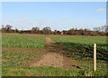
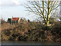
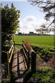
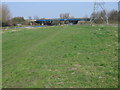
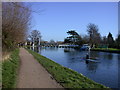
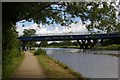
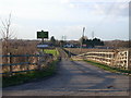
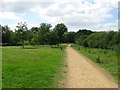
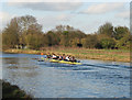
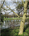
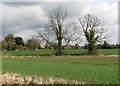
Living in CB5 8TA offers a compact, residential experience rooted in a historic setting. This small postcode area, covering 13.5 hectares, is part of a cluster of homes near Cambridge, with a population of 1,689 spread across 83 people per square kilometre. The area’s proximity to the River Cam and its historical ties to the surrounding fenland create a unique blend of natural and cultural character. Situated approximately 4 miles north-east of Cambridge, it lies on the road to Clayhithe, with easy access to the city’s amenities. The village of Horningsea, just beyond the postcode, is defined by its chalk promontory and ancient marshland, offering a quiet contrast to urban life. Residents benefit from a small, close-knit community feel, with local landmarks such as the parish church of St Peter and the Bait’s Bite Lock on the Cam adding to the area’s charm. The mix of historical significance and practical connectivity makes CB5 8TA appealing to those seeking a balance between tranquillity and accessibility.
- Area Type
- Postcode
- Area Size
- 13.5 hectares
- Population
- 1689
- Population Density
- 83 people/km²
The property market in CB5 8TA is characterised by a high rate of home ownership (63%) and a predominance of houses over flats. This suggests a market skewed towards owner-occupied properties, likely catering to families or long-term residents. The small area size and limited housing stock mean the market is not expansive, with fewer options for buyers compared to larger urban areas. Proximity to Cambridge may make the area attractive to those seeking a quieter base while maintaining access to the city’s economic and cultural hubs. However, the concentration of houses rather than rental properties implies a lower turnover rate, which could benefit buyers looking for stability but may limit availability. For those considering the area, the compact nature of CB5 8TA means potential buyers should explore nearby postcodes for additional options.
House Prices in CB5 8TA
Showing 3 properties
| Address | Type | Beds | Baths | Last Sale Price | Last Sale Date | |
|---|---|---|---|---|---|---|
| Poplar Hall, Horningsea Road, Fen Ditton, CB5 8TA | house | - | - | £510,000 | Jan 2010 | |
| Poplar Hall Farmhouse, Poplar Hall Farm, Horningsea Road, Fen Ditton, CB5 8TA | Semi-detached | - | - | - | - | |
| Poplar Hall Farm, Horningsea Road, Fen Ditton, CB5 8TA | Farm | - | - | - | - |
Energy Efficiency in CB5 8TA
The lifestyle in CB5 8TA is shaped by its proximity to Cambridge and the surrounding natural features. Residents can access five retail spots, including major chains like Tesco and Co-op, ensuring convenience for shopping. The River Cam, with its Bait’s Bite Lock, offers recreational opportunities for boating or leisurely activities. Historical sites such as the parish church of St Peter add cultural depth to the area. The nearby village of Horningsea provides a sense of tradition, with landmarks like the Anglo-Saxon coffin lids and remnants of the Roman Car Dyke canal. While the area lacks large-scale leisure facilities, its small size fosters a community-oriented atmosphere. The combination of retail, transport, and historical sites creates a balanced lifestyle, blending practicality with local heritage.
Amenities
Schools
Residents of CB5 8TA have access to three primary schools within practical reach: Fen Ditton Primary School and Marleigh Primary Academy. Both are primary institutions, though specific Ofsted ratings are not provided in the data. The presence of multiple primary schools suggests a focus on early education, which is beneficial for families with young children. However, the absence of secondary schools in the immediate area means students may need to travel to nearby towns for further education. This could be a consideration for parents planning long-term in the area. The concentration of primary schools indicates a community-oriented approach to education, but families requiring secondary schooling should investigate nearby options in Cambridge or surrounding villages.
| Rank | School | Type | Entry gender | Ages |
|---|
Explore more schools in this area
Go to Schools tabDemographics
The community in CB5 8TA is predominantly composed of adults aged 30-64, with a median age of 47. This suggests a mature, stable population, likely with established careers and family ties. Home ownership is high at 63%, with most properties being houses rather than flats, reflecting a traditional, family-oriented housing stock. The predominant ethnic group is White, which aligns with broader trends in the region. The age profile indicates a community with fewer young children or retirees, which may influence local services and amenities. With no data on deprivation levels, it is unclear how economic factors affect quality of life, but the age range and home ownership figures suggest a relatively settled, middle-aged demographic. The absence of significant diversity data means the community’s social dynamics remain less defined in this context.
Household Size
Accommodation Type
Tenure
Ethnic Group
Religion
Household Composition
Age
Household Deprivation
NS-SEC
Explore more demographic insights in this area
Go to Demographics tabPlanning
Planning Constraints
- Flood RiskPremium
- Ramsar Wetland SitesPremium
- Area of Outstanding Natural BeautyPremium
- Protected Nature ReservePremium
- Protected WoodlandPremium