Area Overview for CB22 3AT
Photos of CB22 3AT

Area Information
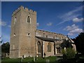
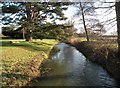
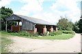
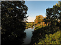
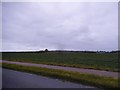
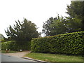
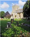
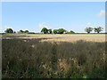
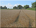
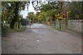
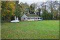
Living in CB22 3AT, a small residential cluster in the heart of Babraham, Cambridgeshire, offers a blend of rural tranquillity and proximity to Cambridge. The area spans 18.1 hectares, housing 1,279 residents with a population density of 47 people per square kilometre. Babraham itself is a village with a strong historical and research-oriented identity, home to the Babraham Institute, a leading centre for cell and molecular biology. The village’s character is shaped by its rural setting, bordered by the River Granta and the Icknield Way (now A11), and its historical roots trace back to Anglo-Saxon times. Daily life here is defined by a tight-knit community, with residents often drawn to the area’s quiet surroundings, historical sites like Babraham Hall, and the presence of research institutions. Proximity to Cambridge, just six miles away, adds convenience for those seeking urban amenities without sacrificing rural charm.
- Area Type
- Postcode
- Area Size
- 18.1 hectares
- Population
- 1279
- Population Density
- 47 people/km²
The property market in CB22 3AT is characterised by a high rate of home ownership (64%) and a predominance of houses as the primary accommodation type. This suggests a community where long-term residency is common, with properties likely to be family homes rather than rental units. The small area size (18.1 hectares) and low population density indicate limited housing stock, meaning buyers should consider the scarcity of available properties. The proximity to Cambridge and the Babraham Research Campus may influence property values, particularly for those seeking homes near research or academic institutions. However, the area’s rural nature and limited infrastructure could make it less appealing for buyers prioritising urban amenities. Those considering the market should also note the potential challenges of limited local development, given the area’s historical and environmental constraints.
House Prices in CB22 3AT
Showing 100 properties
Energy Efficiency in CB22 3AT
Life in CB22 3AT is shaped by its rural character and proximity to historical and research sites. The area’s amenities include five retail outlets, such as Spar Harvest and Co-op Sawston, offering everyday shopping needs. Three railway stations provide access to regional transport, while Cambridge Airport is within reach for those needing air travel. The village’s historical sites, including Babraham Hall and the Babraham Institute, contribute to a unique cultural and academic atmosphere. Residents can enjoy the village’s inns, such as The Angel (1490) and The Swan, which reflect its long heritage. The surrounding landscape, with the River Granta and field boundaries, offers opportunities for outdoor activities. The mix of retail, transport, and historical sites creates a lifestyle that balances rural simplicity with practical connectivity.
Amenities
Schools
The nearest school to CB22 3AT is Babraham CofE (VC) Primary School, which serves the local community with primary education. No secondary schools are listed in the data, meaning families may need to look beyond the immediate area for secondary schooling. The presence of a primary school supports families with young children, though the absence of a secondary school could be a consideration for those requiring a full range of educational options. The school’s type (Church of England voluntary controlled) indicates a mix of state and faith-based funding, which may influence its resources and policies. While the data does not include Ofsted ratings, the school’s location within the village suggests it is accessible to residents, with the village’s compact size making it practical for daily commutes.
| Rank | School | Type | Entry gender | Ages |
|---|
Explore more schools in this area
Go to Schools tabDemographics
The community in CB22 3AT is predominantly composed of adults aged 30-64, with a median age of 47. Home ownership is high, at 64%, and the accommodation type is primarily houses, reflecting a residential area with a focus on family homes. The predominant ethnic group is White, though specific diversity data is not provided. The population density of 47 people per square kilometre suggests a low-density, spread-out settlement typical of rural areas. While the data does not include deprivation metrics, the age profile and home ownership rates indicate a stable, middle-aged population with long-term residency. The absence of significant demographic diversity data means the community’s social fabric is largely defined by its historical and local ties, with little indication of recent migration or transient populations.
Household Size
Accommodation Type
Tenure
Ethnic Group
Religion
Household Composition
Age
Household Deprivation
NS-SEC
Explore more demographic insights in this area
Go to Demographics tabPlanning
Planning Constraints
- Flood RiskPremium
- Ramsar Wetland SitesPremium
- Area of Outstanding Natural BeautyPremium
- Protected Nature ReservePremium
- Protected WoodlandPremium