Area Overview for Castle Point District (B)
Photos of Castle Point District (B)


Area Information
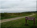
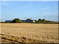
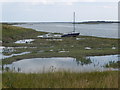
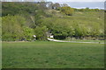
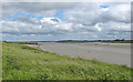
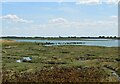
Living in Castle Point District requires an appreciation for local geography alongside practical considerations. This local authority district spans 63.6 square kilometres across Essex. You will find the area serves as a distinct residential zone within the wider borough. The median age here stands at 70 years, marking a notably older population profile compared to many other regions. Daily life involves navigating an environment where high home ownership is the norm. While the broader context of daily living includes access to nearby amenities, the area itself prioritises settled, long-term residence over rapid turnover. Residents expect a community built on stability rather than temporary accommodation. The landscape is defined by specific planning constraints that protect local heritage and nature. You do not find areas of outstanding natural beauty coverage within these specific boundaries, but protected woodland does exist. Flood risk presents a significant factor that every prospective buyer must evaluate carefully. Understanding these core facts forms the basis of deciding whether this location suits your lifestyle requirements. The area functions as a mature, owner-occupied locality with defined environmental parameters.
- Area Type
- District/Borough
- Area Size
- 63.6 km²
- Population
- Not available
- Population Density
- Not available
Demographics
The community within Castle Point District reflects a settled, older population. You will find that the median age is 70 years, indicating a demographic skewed towards retirees and long-term residents. This age profile influences the local market and community dynamics significantly. Home ownership rates reach 80 per cent, confirming that the vast majority of households own their property outright or with a mortgage. This high level of ownership contrasts sharply with areas dominated by rental markets. Household composition data reflects the total population structure without specific breakdowns on family size. The area lacks specific data on predominant ethnic groups or religious affiliations, focusing instead on the established age and ownership metrics. This demographic reality means services and local culture cater primarily to an older, property-owning demographic. Deprivation levels are not explicitly detailed, but the high ownership rate suggests relative economic stability for the bulk of the population. Living here means engaging with a community where established residents make up the core. You should expect a quieter, more mature atmosphere driven by this specific age distribution. The 70-year median age defines the social rhythm of the district clearly.
Household Size
Accommodation Type
Tenure
Ethnic Group
Religion
Household Composition
Age
Household Deprivation
NS-SEC
Explore more demographic insights in this area
Go to Demographics tabPlanning
Planning Constraints
- Flood RiskPremium
- Ramsar Wetland SitesPremium
- Area of Outstanding Natural BeautyPremium
- Protected Nature ReservePremium
- Protected WoodlandPremium