Area Overview for Woodditton
Photos of Woodditton
Area Information
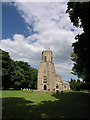
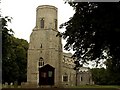
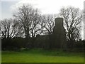
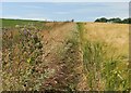
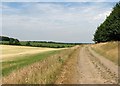
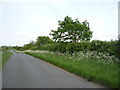
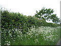
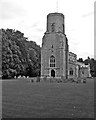
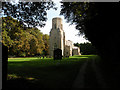
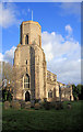
Woodditton occupies 19.3 km² of East Cambridgeshire, positioned immediately south of Newmarket at the southeastern end of Devil's Dyke. This village and civil parish encompasses the settlements of Ditton Green, Little Ditton, and Saxon Street. The area maintains a quiet rural character largely untouched by heavy traffic, distinguishing it from the nearby market town. Woodditton Stud, established in 1851 under ownership connected to Sheikh Mohammed, remains a defining feature alongside Dalham Hall Stud. The landscape includes local woods home to bluebells and deer, while public paths offer access to views of Devil's Ditch and the Icknield Way Roman track. You will find 17th-century structures such as the Three Blackbirds pub, which dates to 1642 and was refurbished following a fire in 2018, blending with some newer residential developments. The Kilbourne family historically resided here since the late 16th century, contributing to the parish's deep roots. This location suits those seeking a peaceful atmosphere away from the bustle of Newmarket while remaining within commuting distance. The parish includes the settlements which formed a cohesive community structure long before the racehorse breeding industry exceeded traditional arable farming as the chief employer.
- Area Type
- Parish
- Area Size
- 19.3 km²
- Population
- Not available
- Population Density
- Not available
Demographics
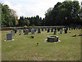
The population of Woodditton reflects a mature community with a median age of 70 years. This demographic profile indicates that the village attracts retirees or families with grown children who move away from denser urban centres. Out of the total population recorded in 2011, which included the surrounding area of Kirtling, 66% of residents are homeowners. This high ownership rate confirms that Woodditton is not primarily a student village or a zone for short-term rentals. The remaining 34% consists of tenants, though the dominant ownership statistic suggests stability and long-term residence. You are likely to neighbour owners of 17th-century cottages or those managing older properties. Household composition data categorises the population as 'total' regarding household type rather than breaking it down into singles, couples, or families. The area's diversity and specific religious breakdowns are recorded as totals without further granularity in current records. The 2011 census figure of 1,818 people defines the scale of the community, making this a small parish where individual residents tend to know one another. Living here means participating in a community where the majority have spent significant time building their lives locally. The age profile suggests you are settling into an area known for its peace rather than vibrancy associated with younger demographics.
Household Size
Accommodation Type
Tenure
Ethnic Group
Religion
Household Composition
Age
Household Deprivation
NS-SEC
Explore more demographic insights in this area
Go to Demographics tabPlanning
Planning Constraints
- Flood RiskPremium
- Ramsar Wetland SitesPremium
- Area of Outstanding Natural BeautyPremium
- Protected Nature ReservePremium
- Protected WoodlandPremium