Area Overview for S18 2XN
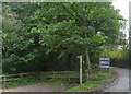
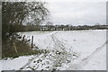
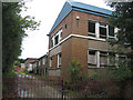
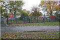
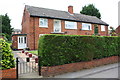
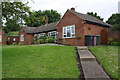
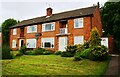
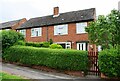
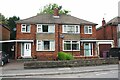
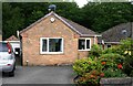
Photos of S18 2XN

Area Information
S18 2XN is a compact residential postcode serving 1,359 people within a 6,452 square metre cluster. This small community sits in a part of Derbyshire characterised by a high population density of 1,054 people per square kilometre. Living in this area means navigating a tight-knit environment where proximity defines daily routines. The postcode functions as a specific residential hub rather than a sprawling neighbourhood, concentrating residents into a defined space. You will find yourself in a location where over half the residents live in houses, creating a sprawling but compact suburban feel typical of the Dronfield region. The area's distinctiveness lies in its density; a significant number of neighbours are within immediate sight and sound. This concentration of homes supports a functional community life where local services are accessible within a short walk or drive. The area is not isolated from the wider network, sitting just minutes from key transportLinks and local shops. Despite the small footprint, the area provides a practical address for those seeking a foothold in Derbyshire without the space requirements of more rural locations. It is a straightforward environment for someone looking to buy or rent a home in a specific, well-defined boundary.
- Area Type
- Postcode
- Area Size
- 6452 m²
- Population
- 1359
- Population Density
- 1054 people/km²
The property market in S18 2XN is defined by a strong presence of owned accommodation. A substantial 48 per cent of residents are owners-occupiers, indicating a mature housing stock where many people have lived in their current homes. Houses dominate the landscape, distinguishing this postcode from areas dominated by rentals or purpose-built blocks. This allocation of houses means that if you are searching for homes in S18 2XN, you will primarily encounter detached or semi-detached properties rather than apartments. The area does not cater to those seeking high-rise living or compact units common in city centres. Instead, the market reflects a traditional suburban model. The prevalence of owner-occupied homes often means properties are better maintained and stay in local hands for longer periods. Buyers looking at this small area will find a market geared towards families or couples who prefer standalone dwellings. The 48 per cent ownership rate also suggests that the area offers opportunities for homeowners looking to exchange properties within a stable community. Those seeking a rental lifestyle will need to look beyond this specific postcode, as the local stock is tailored towards purchase. The housing stock here is practical and designed for everyday family living rather than investment speculation.
House Prices in S18 2XN
No properties found in this postcode.
Energy Efficiency in S18 2XN
Daily life in S18 2XN relies on a cluster of specific amenities located within practical reach. Residents have immediate access to five retail outlets, including Morrisons Daily, Co-op Dronfield, and Spar. These supermarkets provide convenience shopping for groceries and household essentials without a long journey. Transport links are equally important, with five railway stations nearby including Dronfield Railway Station, Dore and Totley Railway Station, and Chesterfield Railway Station. This rail network offers direct connections to larger cities, making commutes to Sheffield, Nottingham, or Manchester feasible. Additionally, five metro platforms such as Herdings Park Platform, Herdings, and White Lane provide local transport options. You also have access to five bus routes via the Coach Station, which connects you to wider regional hubs. If you shop at Co-op Dronfield, you do not need to travel far for daily provisions. The variety of retail options means you can handle weekly shopping locally. Travel to work is flexible, supported by trains and buses running on structured schedules. Living in this area means balancing suburban quiet with the convenience of national rail services. You can choose to drive, take the train to Dronfield, or use the coach for regional trips. The combination of shops and transport stations makes this a practical base for life in Derbyshire.
Amenities
Schools
Families considering S18 2XN have access to three local schools, all rated good by Ofsted. Holmesdale Infant School serves as a primary option for young children, providing early education within the vicinity. Just beyond, Dronfield Stonelow Junior School covers the primary stage, offering continuity for students moving away from infancy education. Further along, Dronfield Henry Fanshawe School provides primary education, completing the immediate educational circle. Each of these three institutions carries a good Ofsted rating, ensuring a consistent standard of education for children living in the area. This concentration of primary education providers is unusual for a small postcode, suggesting that schools have larger catchment areas or that families often travel short distances between sites. If you are moving to S18 2XN, your child will have multiple primary choices nearby without needing to commute far. The mix of infant and junior primary schools indicates a robust local education framework. You do not need to drive into Chesterfield or Derby for primary schooling. The presence of three good-rated schools nearby means that living in S18 2XN keeps your child's education logistics manageable. These schools provide a solid foundation for academic development in the early years.
| Rank | School | Type | Entry gender | Ages |
|---|
Explore more schools in this area
Go to Schools tabDemographics
The community in S18 2XN has a clear demographic profile centred on established adults. The median age stands at 47 years, which aligns with the most common age range of adults between 30 and 64 years. This suggests a neighbourhood composed largely of long-term residents, families raising children, and those in the middle stage of their careers. Home ownership sits at 48 per cent, indicating that nearly half of the households own their properties outright, contributing to community stability. The remaining homes suggest a mix of private rentals or shared ownership schemes. Houses remain the predominant accommodation type, reflecting a preference for standalone living over flats or apartments. The predominant ethnic group is White, which mirrors the broader historical makeup of the region. This demographic profile points to an area where residents have likely put down roots for many years. The lack of a younger population skew or an elderly majority suggests steady household formation rather than empty nesters or students. If you are looking to live in S18 2XN, you are joining a group of people with settled domestic arrangements. The stability of the 47-year median age often correlates with quiet streets and established local networks rather than transient populations.
Household Size
Accommodation Type
Tenure
Ethnic Group
Religion
Household Composition
Age
Household Deprivation
NS-SEC
Explore more demographic insights in this area
Go to Demographics tabPlanning
Planning Constraints
- Flood RiskPremium
- Ramsar Wetland SitesPremium
- Area of Outstanding Natural BeautyPremium
- Protected Nature ReservePremium
- Protected WoodlandPremium