Area Overview for NN3 8XW
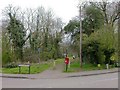
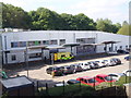
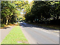
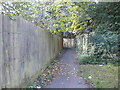
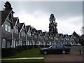
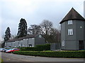
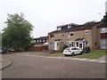
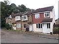
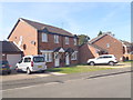
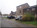
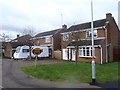
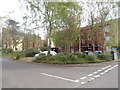
Photos of NN3 8XW
Area Information
NN3 8XW is a compact residential postcode area in England, covering just 4,208 square metres and home to 1,981 residents. Its high population density of 470,793 people per square kilometre reflects a tightly knit community, though the area’s small size means it is best suited for those prioritising proximity to local amenities. The postcode is characterised by a mix of housing stock, with a median age of 47 and a majority of residents aged between 30 and 64. This suggests a mature, stable population, likely with established careers and families. The area is near Greenfields School and Sports College and Greenfields Specialist School for Communication, indicating a focus on education. While the area lacks natural or protected landscapes, its proximity to Northampton’s transport hubs and retail centres, including Co-op Northampton and Lidl Lings, ensures daily life is convenient. However, the medium crime risk score of 52 means residents should remain vigilant about standard security measures. For buyers seeking a quiet, connected residential spot with practical amenities, NN3 8XW offers a blend of accessibility and compact living.
- Area Type
- Postcode
- Area Size
- 4208 m²
- Population
- 1981
- Population Density
- 4951 people/km²
The property market in NN3 8XW is defined by a 47% home ownership rate, with houses being the predominant accommodation type. This indicates a mix of owner-occupied properties and rentals, though the small area size suggests limited housing stock. The presence of houses rather than flats or apartments may appeal to buyers seeking larger living spaces, though the compact postcode means opportunities for expansion are constrained. With a population density over 470,000 people per square kilometre, the area is likely to have a competitive market for available homes. Buyers should consider that the high density may lead to higher demand for properties near key amenities such as Northampton Railway Station and the nearby retail hubs. The market’s character is shaped by its proximity to transport links and schools, making it attractive to families and commuters.
House Prices in NN3 8XW
Showing 1 properties
| Address | Type | Beds | Baths | Last Sale Price | Last Sale Date | |
|---|---|---|---|---|---|---|
| Goldings Post Office, Unit 1, Prentice Court, Northampton, NN3 8XW | Flat | - | - | - | - |
Energy Efficiency in NN3 8XW
Living in NN3 8XW offers access to a range of local amenities within practical reach. Retail options include Co-op Northampton, Tesco Northampton, and Lidl Lings, providing everyday shopping convenience. The area’s proximity to Northampton Bus Interchange and University Bus Interchange ensures easy access to public transport, connecting residents to broader networks. While the area lacks extensive parks or leisure facilities, its compact size means residents can quickly reach Northampton’s larger amenities. The presence of two special schools and a railway station adds to the area’s practicality, making it suitable for families and commuters. The combination of retail, transport, and educational hubs creates a functional lifestyle, though buyers should consider the limited scope for outdoor recreation in the immediate vicinity.
Amenities
Schools
The nearest schools to NN3 8XW include Greenfields School and Sports College and Greenfields Specialist School for Communication, both of which are special schools. These institutions cater to students with specific educational needs, suggesting the area may attract families requiring tailored support for children. While no Ofsted ratings are provided, the presence of two special schools indicates a focus on inclusive education. For parents seeking mainstream schooling, the area’s proximity to Northampton’s broader network of schools may be a consideration. The concentration of specialist education in the vicinity could make NN3 8XW appealing to those prioritising accessible resources for children with additional needs, though buyers should verify the full range of local educational options.
| Rank | School | Type | Entry gender | Ages |
|---|
Explore more schools in this area
Go to Schools tabDemographics
The population of NN3 8XW is predominantly adults aged 30 to 64, with a median age of 47. This suggests a community of working-age individuals and families, likely with long-term ties to the area. Home ownership stands at 47%, indicating a mix of owner-occupied and rental properties. The accommodation type is primarily houses, which may appeal to those seeking more space than flats. The predominant ethnic group is White, though no specific data on diversity or deprivation is provided. The high population density of 470,793 people per square kilometre implies a closely packed residential environment, which could influence the availability of private outdoor space. For buyers, this demographic profile suggests a stable, mature community with established local networks, though the lack of data on income or deprivation means broader quality-of-life factors remain unquantified.
Household Size
Accommodation Type
Tenure
Ethnic Group
Religion
Household Composition
Age
Household Deprivation
NS-SEC
Explore more demographic insights in this area
Go to Demographics tabPlanning
Planning Constraints
- Flood RiskPremium
- Ramsar Wetland SitesPremium
- Area of Outstanding Natural BeautyPremium
- Protected Nature ReservePremium
- Protected WoodlandPremium