Area Overview for NN3 8SG
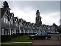
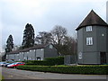
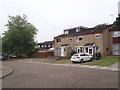
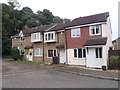
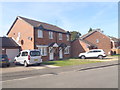
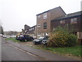
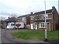
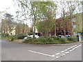
Photos of NN3 8SG
Area Information
Living in NN3 8SG means inhabiting a compact residential cluster in England, where 1,981 people reside across just 1.9 hectares. This density creates a tightly knit community, with homes predominantly in private ownership. The area’s small footprint means amenities and services are within close reach, though its size also limits expansion. With a median age of 47, the population skews towards adults aged 30–64, suggesting a stable, established demographic. Daily life here balances proximity to essential services with the quietude of a small area. While the postcode lacks natural or protected landscapes, it offers practical living with no significant environmental constraints. Residents benefit from strong broadband connectivity, though mobile coverage is slightly less robust. The area’s character is defined by its practicality, with a focus on accessibility to retail, transport, and education. For those seeking a compact, functional home without the sprawl of larger towns, NN3 8SG provides a straightforward, no-frills living environment.
- Area Type
- Postcode
- Area Size
- 1.9 hectares
- Population
- 1981
- Population Density
- 4951 people/km²
The property market in NN3 8SG is characterised by a 47% home ownership rate, with houses being the primary accommodation type. This suggests a focus on private, family-oriented housing rather than rental properties or flats. Given the area’s small size and high population density, the housing stock is likely limited, with properties concentrated in a compact footprint. For buyers, this means competition for available homes, particularly as the area’s size restricts new development. The predominance of houses may appeal to those seeking larger living spaces, though the lack of data on property sizes or price ranges means potential buyers must consider local listings carefully. The high ownership rate also implies a stable market, with fewer turnover fluctuations compared to rental-heavy areas. However, the limited geographical scope of NN3 8SG means buyers should assess proximity to surrounding regions for additional options.
House Prices in NN3 8SG
Showing 65 properties
| Address | Type | Beds | Baths | Last Sale Price | Last Sale Date | |
|---|---|---|---|---|---|---|
| 47 Dell Crescent, Northampton, NN3 8SG | Terraced | 3 | 2 | £190,000 | Sep 2023 | |
| 12 Dell Crescent, Northampton, NN3 8SG | Terraced | 3 | 1 | £215,000 | Aug 2023 | |
| 54 Dell Crescent, Northampton, NN3 8SG | Terraced | 2 | 1 | £180,000 | Apr 2023 | |
| 6 Dell Crescent, Northampton, NN3 8SG | house | - | - | £185,000 | Dec 2021 | |
| 48 Dell Crescent, Northampton, NN3 8SG | Terraced | 3 | - | £215,000 | Sep 2021 | |
| 32 Dell Crescent, Northampton, NN3 8SG | house | 1 | - | £143,000 | Apr 2021 | |
| 50 Dell Crescent, Northampton, NN3 8SG | Terraced | 3 | - | £162,000 | Mar 2021 | |
| 51 Dell Crescent, Northampton, NN3 8SG | house | - | - | £118,000 | Dec 2020 | |
| 8 Dell Crescent, Northampton, NN3 8SG | Terraced | 3 | 1 | £150,000 | Jul 2020 | |
| 37 Dell Crescent, Northampton, NN3 8SG | Terraced | 2 | 1 | £145,000 | Feb 2020 |
Energy Efficiency in NN3 8SG
Daily life in NN3 8SG is shaped by its proximity to essential amenities. Residents can access major retailers like Co-op Northampton, Tesco Northampton, and Aldi Overstone, ensuring convenience for shopping and daily needs. The area’s transport links are robust, with the University Bus Interchange and Northampton Bus Interchange offering frequent services, while Northampton Railway Station provides rail access to broader destinations. Though the area itself is small, its connectivity to surrounding regions means residents can easily access larger towns for leisure, dining, or cultural activities. The lack of parks or green spaces is notable, but the absence of environmental constraints like protected woodlands or AONB designations means development pressure is minimal. This balance of practicality and accessibility defines the lifestyle in NN3 8SG, catering to those prioritising convenience over expansive natural landscapes.
Amenities
Schools
Residents of NN3 8SG have access to two special schools: Greenfields School and Sports College, and Greenfields Specialist School for Communication. Both institutions cater to specific educational needs, though their Ofsted ratings are not provided in the data. The presence of two special schools indicates a focus on tailored education, which may be particularly relevant for families with children requiring specialist support. However, the absence of mainstream schools in the area means parents may need to consider commuting to nearby districts for broader educational options. This mix of school types reflects a community prioritising inclusive education, though it also highlights the need for strategic planning when choosing a home based on school proximity.
| Rank | School | Type | Entry gender | Ages |
|---|
Explore more schools in this area
Go to Schools tabDemographics
The community in NN3 8SG is predominantly composed of adults aged 30–64, with a median age of 47. This suggests a population largely in their prime working years, potentially influencing local services and housing demand. Home ownership stands at 47%, with houses being the primary accommodation type. This contrasts with areas where rental properties dominate, indicating a mix of long-term residents and those seeking private ownership. The predominant ethnic group is White, though specific data on diversity or deprivation is not provided. The population density of 106,442 people per square kilometre is exceptionally high, reflecting the area’s small size and concentrated housing. This density may impact living space per household but also fosters a closely connected community. For buyers, understanding the age profile and ownership rates can inform decisions about property suitability and long-term stability in the area.
Household Size
Accommodation Type
Tenure
Ethnic Group
Religion
Household Composition
Age
Household Deprivation
NS-SEC
Explore more demographic insights in this area
Go to Demographics tabPlanning
Planning Constraints
- Flood RiskPremium
- Ramsar Wetland SitesPremium
- Area of Outstanding Natural BeautyPremium
- Protected Nature ReservePremium
- Protected WoodlandPremium