Area Overview for NN29 7SU
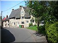
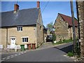
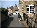
Photos of NN29 7SU


Area Information
NN29 7SU is a compact residential cluster in England, covering just 1.5 hectares and home to 1,641 residents. Its small size means the area is densely populated, with 609 people per square kilometre, yet it retains a quiet, community-focused character. This postcode is typical of a small, stable neighbourhood where most residents are homeowners. The median age of 47 suggests a mature population, with the majority aged between 30 and 64. Daily life here is likely to revolve around local amenities, with shops and transport links within easy reach. The area’s proximity to Wellingborough Railway Station and nearby retail outlets like Tesco and Co-op indicates practical connectivity for both commuting and everyday needs. While the built environment is limited to houses, the compact nature of the area fosters a sense of familiarity, making it appealing to those seeking a settled, low-maintenance lifestyle. The absence of major environmental constraints or planning restrictions adds to its straightforward appeal. For buyers, NN29 7SU offers a snapshot of a small town’s charm, with a focus on stability and convenience.
- Area Type
- Postcode
- Area Size
- 1.5 hectares
- Population
- 1641
- Population Density
- 609 people/km²
The property market in NN29 7SU is characterised by high home ownership, with 86% of residents owning their homes. This suggests a stable, owner-occupied market rather than a rental-focused one, which is typical of smaller, established communities. The area is composed entirely of houses, with no flats or apartments, indicating a housing stock that caters to families or individuals seeking larger, more private living spaces. Given the small size of the postcode—just 1.5 hectares—the number of available properties is likely limited, making the market competitive for buyers. The high home ownership rate also implies that properties may be held for the long term, reducing the likelihood of frequent turnover. For prospective buyers, this means a focus on quality and condition rather than quantity, with homes likely to be well-maintained. The immediate surroundings may offer additional options, but the core of NN29 7SU itself is a tightly knit area with limited new development.
House Prices in NN29 7SU
Showing 27 properties
| Address | Type | Beds | Baths | Last Sale Price | Last Sale Date | |
|---|---|---|---|---|---|---|
| 14 Unity Close, Wollaston, NN29 7SU | Detached | 4 | 3 | £340,000 | Nov 2025 | |
| 22 Unity Close, Wollaston, NN29 7SU | Semi-detached | 3 | 1 | £252,500 | Aug 2024 | |
| 6 Unity Close, Wollaston, NN29 7SU | house | - | - | £299,995 | Aug 2022 | |
| 2 Unity Close, Wollaston, NN29 7SU | Detached | 4 | 1 | £316,000 | May 2018 | |
| 7 Unity Close, Wollaston, NN29 7SU | house | - | - | £169,995 | Sep 2015 | |
| 26 Unity Close, Wollaston, NN29 7SU | Semi-detached | 3 | - | £155,000 | Oct 2014 | |
| 19 Unity Close, Wollaston, NN29 7SU | house | - | - | £169,000 | Nov 2013 | |
| 21 Unity Close, Wollaston, NN29 7SU | house | - | - | £148,000 | Dec 2009 | |
| 24 Unity Close, Wollaston, NN29 7SU | Semi-detached | - | - | £145,000 | Jul 2007 | |
| 15 Unity Close, Wollaston, NN29 7SU | Semi-detached | - | - | £160,000 | Mar 2007 |
Energy Efficiency in NN29 7SU
The lifestyle in NN29 7SU is shaped by its proximity to essential amenities. Nearby retail options include Co-op Wollaston, Co-op Irchester, and Tesco Wellingborough, providing a range of grocery and convenience shopping choices. These stores are within practical walking or driving distance, supporting a self-sufficient daily routine. The area’s small size means that residents are likely to know their local shops and services, fostering a sense of community. The Wellingborough Railway Station adds to the area’s connectivity, offering access to further destinations for work, leisure, or travel. While the data does not mention parks or leisure facilities, the absence of environmental constraints like protected woodlands or AONB status suggests that open spaces may be limited. Nonetheless, the combination of retail and transport links ensures that daily life in NN29 7SU is functional and convenient, with a focus on practicality over luxury.
Amenities
Schools
Residents of NN29 7SU have access to Wollaston School, which serves as both a primary school and an academy with a good Ofsted rating. This dual role means the school caters to a wide range of educational needs, from early years to secondary-level learning. The good Ofsted rating indicates that the school meets or exceeds national standards in teaching, leadership, and student outcomes. For families, having a primary school and an academy within the same institution offers convenience and continuity in education. The presence of a rated school is a significant draw for buyers prioritising family-friendly amenities. While no other schools are listed in the data, the availability of a well-regarded school suggests that the area is appealing to households with children. The school’s performance also reflects the broader quality of education in the region, which is likely to be a key consideration for prospective buyers.
| Rank | School | Type | Entry gender | Ages |
|---|
Explore more schools in this area
Go to Schools tabDemographics
The community in NN29 7SU is predominantly composed of adults aged 30 to 64, with a median age of 47. This suggests a population that is largely established, with many likely to be in their peak working years or nearing retirement. Home ownership is exceptionally high at 86%, indicating a strong preference for long-term residency and a stable housing market. The area is almost entirely made up of houses, with no flats or apartments listed, which aligns with the demographic profile of older, family-oriented residents. The predominant ethnic group is White, with no data provided on other ethnicities, though this reflects broader regional trends. The high home ownership rate and age profile suggest a community with low turnover and a focus on comfort over mobility. For buyers, this means a market where properties are likely to be well-maintained and held by long-term residents. The absence of significant deprivation indicators implies a quality of life that is consistent with the area’s infrastructure and services.
Household Size
Accommodation Type
Tenure
Ethnic Group
Religion
Household Composition
Age
Household Deprivation
NS-SEC
Explore more demographic insights in this area
Go to Demographics tabPlanning
Planning Constraints
- Flood RiskPremium
- Ramsar Wetland SitesPremium
- Area of Outstanding Natural BeautyPremium
- Protected Nature ReservePremium
- Protected WoodlandPremium