Area Overview for NN29 7SL
Photos of NN29 7SL

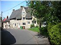
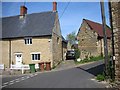
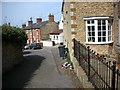


16 photos from this area
Area Information
Key information about the NN29 7SL including its size, population, and administrative classification.
- Area Type
- Postcode
- Area Size
- 2.3 hectares
- Population
- 1641
- Population Density
- 609 people/km²
House Prices in NN29 7SL
13
Properties
£543,718
Average Sold Price
£130,000
Lowest Price
£1,650,000
Highest Price
Showing 13 properties
| Address | Type | Beds | Baths | Last Sale Price | Last Sale Date | |
|---|---|---|---|---|---|---|
| 1 Hickmire, Wollaston, NN29 7SL | Retail | 8 | 5 | £1,650,000 | Sep 2022 | |
| 2 Hickmire, Wollaston, NN29 7SL | Bungalow | 5 | - | £828,750 | Dec 2020 | |
| 12 Hickmire, Wollaston, NN29 7SL | Cottage | 2 | 1 | £238,000 | Aug 2016 | |
| 8 Hickmire, Wollaston, NN29 7SL | Terraced | 2 | - | £250,000 | Sep 2014 | |
| 14 Hickmire, Wollaston, NN29 7SL | Cottage | 3 | 1 | £279,995 | Jul 2014 | |
| 18 Hickmire, Wollaston, NN29 7SL | Detached | 3 | - | £243,000 | Dec 2013 | |
| 25 Hickmire, Wollaston, NN29 7SL | Detached | 4 | - | £730,000 | Dec 2009 | |
| 23 Hickmire, Wollaston, NN29 7SL | house | - | - | £130,000 | Jun 2003 | |
| 17 Hickmire, Wollaston, NN29 7SL | Detached | 4 | 3 | - | - | |
| 21 Hickmire, Wollaston, NN29 7SL | Cottage | 2 | 1 | - | - |
Page 1 of 2
Energy Efficiency in NN29 7SL
Amenities
Schools
| Rank | School | Type | Entry gender | Ages |
|---|
Explore more schools in this area
Go to Schools tabDemographics
Household Size
Two person
most common
Accommodation Type
Houses
most common
Tenure
86
majority
Ethnic Group
White
most common
Religion
N/A
most common
Household Composition
N/A
most common
Age
47
median
Adults (30-64 years)
most common
Household Deprivation
N/A
with no deprivation
NS-SEC
42
in Lower managerial occupations
Explore more demographic insights in this area
Go to Demographics tabPlanning
Planning Constraints
- Flood RiskPremium
- Ramsar Wetland SitesPremium
- Area of Outstanding Natural BeautyPremium
- Protected Nature ReservePremium
- Protected WoodlandPremium