Area Overview for NN18 8SQ
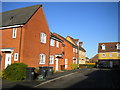
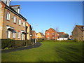
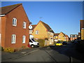
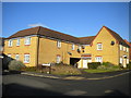
Photos of NN18 8SQ

Area Information
Living in NN18 8SQ means being part of a tightly knit residential cluster in Corby, Northamptonshire. This small area covers just 8,633 square metres, yet it accommodates 2,727 residents, resulting in a high population density of 315,863 people per square kilometre. The postcode sits in a town with a rich industrial heritage, once dominated by steelworks that transformed it from a village into a major settlement. Today, NN18 8SQ reflects a mature community, with a median age of 47 and a strong presence of adults aged 30–64. Daily life here balances the convenience of nearby retail and transport links with the quiet character of a post-industrial town. Corby’s historical roots as a new town from 1950 and its connection to the steel industry still shape its identity, though modern infrastructure like broadband and rail networks now support a practical lifestyle. The area is ideal for those seeking a compact, well-connected home without the sprawl of larger cities, though its density may feel intense for some.
- Area Type
- Postcode
- Area Size
- 8633 m²
- Population
- 2727
- Population Density
- 6790 people/km²
The property market in NN18 8SQ is characterised by a high rate of home ownership (74%) and a focus on houses rather than flats or apartments. This suggests a market skewed towards owner-occupied properties, likely appealing to families or individuals seeking long-term stability. The dominance of houses may also indicate limited rental stock, which could make the area less attractive to tenants or first-time buyers seeking more affordable options. Given the small area size of 8,633 square metres, the housing stock is likely concentrated, with little scope for expansion. Buyers should consider that proximity to amenities like Tesco Oakley, Lidl Central, and nearby rail stations may influence property values, though the compact nature of the postcode means competition for homes could be fierce. For those prioritising ownership and a traditional housing format, NN18 8SQ offers a clear opportunity, but its limited scale may restrict choices.
House Prices in NN18 8SQ
Showing 15 properties
| Address | Type | Beds | Baths | Last Sale Price | Last Sale Date | |
|---|---|---|---|---|---|---|
| 2 Hillary Close, Corby, NN18 8SQ | Detached | 4 | 1 | £320,000 | Sep 2021 | |
| 9 Hillary Close, Corby, NN18 8SQ | Detached | 4 | 2 | £280,000 | Nov 2020 | |
| 10 Hillary Close, Corby, NN18 8SQ | Detached | 4 | 1 | £300,000 | Jan 2018 | |
| 6 Hillary Close, Corby, NN18 8SQ | Detached | 4 | - | £254,000 | Nov 2017 | |
| 4 Hillary Close, Corby, NN18 8SQ | house | - | - | £250,000 | Jun 2015 | |
| 11 Hillary Close, Corby, NN18 8SQ | house | - | - | £206,995 | Jun 2014 | |
| 17 Hillary Close, Corby, NN18 8SQ | house | - | - | £208,995 | May 2014 | |
| 19 Hillary Close, Corby, NN18 8SQ | house | - | - | £227,696 | May 2014 | |
| 7 Hillary Close, Corby, NN18 8SQ | house | - | - | £203,995 | May 2014 | |
| 15 Hillary Close, Corby, NN18 8SQ | house | - | - | £169,995 | May 2014 |
Energy Efficiency in NN18 8SQ
Life in NN18 8SQ is supported by a range of nearby amenities within practical reach. Retail options include Tesco Oakley, Lidl Central, and Tesco Corby, offering everyday shopping needs. These stores provide convenience for residents, reducing the need for long trips to larger centres. The area’s rail links to Corby and Kettering stations make commuting to nearby towns straightforward, while the bus interchange adds flexibility for local travel. Though the postcode is small, its proximity to these amenities ensures a functional lifestyle. The lack of extensive parks or leisure facilities means outdoor recreation may require venturing beyond the immediate area. However, the presence of multiple retail outlets and transport hubs contributes to a practical, if modest, quality of life, particularly for those prioritising convenience over expansive leisure options.
Amenities
Schools
| Rank | School | Type | Entry gender | Ages |
|---|
Explore more schools in this area
Go to Schools tabDemographics
The community in NN18 8SQ is predominantly composed of adults aged 30–64, with a median age of 47. This suggests a stable population with a strong presence of middle-aged residents, likely many of whom are long-term residents or working professionals. Home ownership is high at 74%, indicating a community of homeowners rather than renters, which can contribute to a sense of permanence. The accommodation type is primarily houses, reflecting a preference for single-family dwellings over flats or apartments. The predominant ethnic group is White, which aligns with broader demographic trends in the region. While specific data on deprivation is not provided, the high home ownership rate and mature age profile suggest a relatively stable socioeconomic environment. However, the lack of detailed diversity metrics means the full range of community experiences here remains partially unexplored.
Household Size
Accommodation Type
Tenure
Ethnic Group
Religion
Household Composition
Age
Household Deprivation
NS-SEC
Explore more demographic insights in this area
Go to Demographics tabPlanning
Planning Constraints
- Flood RiskPremium
- Ramsar Wetland SitesPremium
- Area of Outstanding Natural BeautyPremium
- Protected Nature ReservePremium
- Protected WoodlandPremium