Area Overview for NN18 0ST
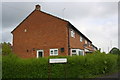
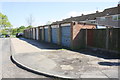
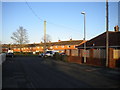
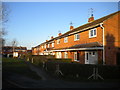
Photos of NN18 0ST


Area Information
NN18 0ST is a compact residential postcode area in England, encompassing a small cluster of homes within Corby, Northamptonshire. With a population of 1,589 spread over just 1,626 square metres, the area is densely populated, reflecting Corby’s historical role as a planned industrial town. The community is predominantly middle-aged, with a median age of 47 and a majority of residents aged 30–64. This suggests a settled, family-oriented demographic, though home ownership is relatively low at 36%, indicating a mix of rental properties and owner-occupied homes. The area’s proximity to Corby’s industrial heritage and modern amenities creates a unique blend of practicality and convenience. Residents benefit from nearby retail options like Iceland Corby and Lidl, as well as transport links including Corby Railway Station. The high broadband score of 99 ensures excellent digital connectivity, while the presence of schools such as Hazel Leys Infant School and Maplefields School caters to local families. Despite its small size, NN18 0ST offers a functional living environment for those seeking accessibility to services and a connection to Corby’s evolving character.
- Area Type
- Postcode
- Area Size
- 1626 m²
- Population
- 1589
- Population Density
- 6261 people/km²
The property market in NN18 0ST is characterised by a low home ownership rate of 36%, indicating that the majority of properties are rented rather than owned. The accommodation type is primarily houses, which is notable in a small postcode area, suggesting a mix of larger, more traditional homes. This contrasts with urban centres where flats are more common. For buyers, the limited size of the area means the housing stock is constrained, with few new developments likely to arise. The focus on owner-occupied homes is minimal, so prospective buyers may find limited opportunities for purchase. The area’s small footprint and high density also mean that property values could be influenced by proximity to amenities such as Corby Railway Station and retail hubs like Iceland Corby. Investors or buyers seeking owner-occupied properties may need to look beyond the immediate postcode for more options.
House Prices in NN18 0ST
Showing 4 properties
| Address | Type | Beds | Baths | Last Sale Price | Last Sale Date | |
|---|---|---|---|---|---|---|
| 4 Mackintosh Court, Corby, NN18 0ST | Bungalow | - | - | - | - | |
| 1 Mackintosh Court, Corby, NN18 0ST | Bungalow | - | - | - | - | |
| 2 Mackintosh Court, Corby, NN18 0ST | Bungalow | - | - | - | - | |
| 3 Mackintosh Court, Corby, NN18 0ST | Bungalow | - | - | - | - |
Energy Efficiency in NN18 0ST
The lifestyle in NN18 0ST is shaped by its proximity to retail and transport hubs. Residents can access supermarkets such as Iceland Corby, Lidl Central, and Farmfoods Corby, ensuring convenience for daily shopping. The area’s rail link to Corby Railway Station and the nearby bus interchange provide connectivity to surrounding regions, supporting both work and leisure travel. While the data does not mention parks or recreational spaces, the presence of schools and shops suggests a focus on practicality over expansive leisure facilities. The compact nature of the postcode means amenities are tightly clustered, fostering a sense of community. However, the high population density may limit private outdoor space, requiring residents to rely on shared or public areas for recreation. The lifestyle here is functional, prioritising accessibility to services over expansive natural environments.
Amenities
Schools
NN18 0ST is served by two schools: Hazel Leys Infant School, a primary school, and Maplefields School, a special needs institution. The presence of both a primary and a special school suggests the area caters to a range of educational needs, including support for children with additional requirements. Hazel Leys Infant School would serve younger children, providing a foundation for early education, while Maplefields School addresses the needs of students requiring tailored support. Families with children may benefit from the proximity of these schools, though the absence of secondary schools in the immediate vicinity could necessitate travel to nearby areas. The mix of school types reflects the community’s diversity and the importance of accessible education for all residents.
| Rank | School | Type | Entry gender | Ages |
|---|
Explore more schools in this area
Go to Schools tabDemographics
The population of NN18 0ST is 1,589, with a median age of 47 and a majority of residents aged 30–64. This suggests a community skewed towards middle-aged adults, likely including families and professionals. Home ownership is at 36%, meaning a significant proportion of residents rent their homes, which may reflect the area’s history as a planned industrial settlement with a focus on workforce housing. The predominant accommodation type is houses, rather than flats, indicating a traditional residential layout. The ethnic composition is predominantly White, though specific diversity metrics are not provided. The high population density—977,526 people per square kilometre—means the area is intensely populated, which may influence the availability of private outdoor space. This density, combined with the age profile, suggests a community with established routines and a reliance on local services for daily needs.
Household Size
Accommodation Type
Tenure
Ethnic Group
Religion
Household Composition
Age
Household Deprivation
NS-SEC
Explore more demographic insights in this area
Go to Demographics tabPlanning
Planning Constraints
- Flood RiskPremium
- Ramsar Wetland SitesPremium
- Area of Outstanding Natural BeautyPremium
- Protected Nature ReservePremium
- Protected WoodlandPremium