Area Overview for NG9 2NZ
Photos of NG9 2NZ

Area Information
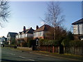
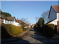
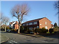
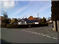
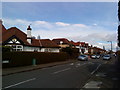
Living in NG9 2NZ means residing in a specific residential cluster characterised by a compact footprint of just 1138 square metres. This postcode area supports a population of 2159 people, creating a defined neighbourhood within the wider Nottingham region. You are situated in a setting where daily life revolves around a mix of established homes and practical access to local services. The area functions as a small but functional residential unit rather than a sprawling town centre. Your location places you close to key transport hubs and retail outlets, ensuring that essentials are within practical reach without the noise of heavy traffic often found in larger urban zones. The community is tightly knit due to the limited geographic spread, which fosters a sense of familiarity among residents. When you consider what makes this location distinctive, it is the balance between proximity to Nottingham city centre and the quieter, contained nature of a specific postcode zone. Life here is straightforward, with clear boundaries and a focus on domestic comfort. You do not need to travel far for basic amenities, though the area's size means it serves as a gateway to wider facilities rather than a self-contained city.
- Area Type
- Postcode
- Area Size
- 1138 m²
- Population
- Not available
- Population Density
- Not available
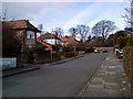
The property market in NG9 2NZ is characterised by a significant concentration of houses, which serves as the primary accommodation type for the 2159 residents living here. With home ownership sitting at 51%, this figure indicates that just over half of the households have purchased their residences, leaving the other half in the rental sector. This balanced split suggests that the area appeals equally to buyers looking to settle down and investors or landlords seeking tenants. As a specific postcode covering a small residential cluster, you will find that the housing stock is likely dominated by individual houses rather than high-density flats or purpose-built rental blocks. When searching for homes in NG9 2NZ, your focus should be on the established residential properties that define this neighbourhood. The 51% ownership rate implies a mature market where many owners have likely lived in their properties for years. This stability often correlates with lower turnover rates compared to areas with higher rental percentages. Buyers looking at this small area should expect a traditional housing landscape suited to families or professionals seeking space and privacy within a manageable living environment.
House Prices in NG9 2NZ
Showing 4 properties
| Address | Type | Beds | Baths | Last Sale Price | Last Sale Date | |
|---|---|---|---|---|---|---|
| Transform Training, 76A Wollaton Road, Beeston, NG9 2NZ | Office | - | - | - | - | |
| Cds Consulting, 78 Wollaton Road, Beeston, NG9 2NZ | retail_financial | - | - | - | - | |
| 8ZERO Creative Ltd, 72-B-74-A Wollaton Road, Beeston, NG9 2NZ | office_workshop | - | - | - | - | |
| 74A Wollaton Road, Beeston, NG9 2NZ | Office | - | - | - | - |
Energy Efficiency in NG9 2NZ
Residents of NG9 2NZ enjoy convenient access to a range of amenities within practical reach, though the immediate vicinity is best served by locations like Beeston Centre. You have five retail options nearby, including Lidl Beeston, Sainsburys Beeston, and Tesco Nottingham, offering everything from daily groceries to general goods without the need to travel far into the city. Public transport links are extensive, with five metro and five rail options available, including the Beeston Centre Tram Stop, Beeston Railway Station, and Nottingham Railway Station. Nottingham Airport is also within reach, providing flight connections for residents who need to travel by air. These five transport categories ensure that daily commutes are efficient, whether you are catching a tram or driving to a supermarket. The presence of a tram and bus interchange allows you to integrate easily into the wider Nottingham transport network. Living in this area means you do not have to sacrifice convenience for the quieter residential character of a small cluster.
Amenities
Schools
Families considering schools near NG9 2NZ have access to Round Hill Primary School, which carries an Ofsted rating of Good. This primary institution serves the early education needs of the local community and is the only school listed within the immediate vicinity of this postcode. While the data does not specify secondary schools, the presence of a rated primary school indicates a reasonable provision for younger children. The single listing for a primary school suggests that the immediate area is focused on early years education, with secondary options likely located in the wider Beeston or Nottingham catchment areas. For parents, the Good rating provides assurance of a quality educational environment where students receive effective instruction. When evaluating living in NG9 2NZ, you must account for transport links to bring older children to secondary facilities beyond this single primary option. The existence of a good-rated primary school supports the area's appeal to those managing young households, though further research would be needed to map full secondary routes.
| Rank | School | Type | Entry gender | Ages |
|---|
Explore more schools in this area
Go to Schools tabDemographics
The community in NG9 2NZ is defined by a mature demographic profile with a median age of 47 years. The most common age range among residents falls between 30 and 64 years, indicating a neighbourhood populated by adults rather than young families or retirement cohorts. This age distribution suggests a stable environment where long-term residents often remain in the area for extended periods. Home ownership stands at 51%, reflecting a balanced market where roughly half of the households own their properties outright or with a mortgage, while the other half likely rent. Houses form the predominant accommodation type, confirming that this postcode consists mainly of detached or semi-detached family dwellings rather than apartment blocks. The area is predominantly white, aligning with the broader demographic patterns of this region of England. The sample size of 2159 residents provides a clear picture of who lives here without the volatility of a transient population. You can expect a community where stability is common and neighbours tend to have established roots in the district.
Household Size
Accommodation Type
Tenure
Ethnic Group
Religion
Household Composition
Age
Household Deprivation
NS-SEC
Explore more demographic insights in this area
Go to Demographics tabPlanning
Planning Constraints
- Flood RiskPremium
- Ramsar Wetland SitesPremium
- Area of Outstanding Natural BeautyPremium
- Protected Nature ReservePremium
- Protected WoodlandPremium